Hell's Glen
| Hell's Glen | |
|---|---|
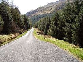 The road through Hell's Glen is the B839. | |
| Highest point | |
| Coordinates | Coordinates: 56°13′01″N 4°56′46″W / 56.217°N 4.946°W grid reference NN1820306549 |
| Geography | |
| Location | Cowal, Argyll and Bute, Scotland. |
| Country | Scotland |
| Geology | |
| Mountain type | Glen |
Hell's Glen is a glen on the Cowal Peninsula, in the Arrochar Alps between the mountains Cruach nam Mult and Stob an Eas. To the west, it leads to Loch Fyne and to the east, the high mountain Ben Donich. The glen is within the Argyll Forest Park that is itself within the Loch Lomond and The Trossachs National Park.[1][2]
The glen is named from its name in Gaelic, Glen Iarainn. This actually means the Iron Glen but sounds like the nearby Glen Ifhrinn which really means the Glen of Hell.[3] The glen is also known as Scottish Gaelic: An Gleann Beag, "the small glen".
Moses' Well
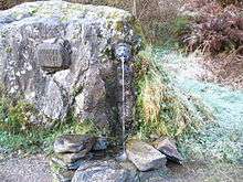
On the south-west side of the glen is a jumble of rocks. In the 19th century, a local minister constructed a spring in one of the rocks which was named after the incident in Exodus:
| “ | And the LORD said unto Moses, Go on before the people, and take with thee of the elders of Israel; and thy rod, wherewith thou smotest the river, take in thine hand, and go. Behold, I will stand before thee there upon the rock in Horeb; and thou shalt smite the rock, and there shall come water out of it, that the people may drink. And Moses did so in the sight of the elders of Israel. |
” |
This then became a stop at which coaching horses would drink.[4]
References
- ↑ http://scotland.forestry.gov.uk/images/pdf/rec_pdfs/ArgyllFPguide.pdf
- ↑ http://www.lochlomond-trossachs.org/rr-content/uploads/2016/07/Downloadable-map-of-Loch-Lomond-and-the-Trossachs-National-Park.pdf
- ↑ "Among the Hills", Temple Bar, 27: 102, November 1869
- ↑ William Gunn; Charles Thomas Clough; Jethro Justinian Harms Teall (1897), The geology of Cowal, p. 286
External links
- Map sources for Hell's Glen
- Argyll Forest Park - website
- The Loch Lomond and The Trossachs National Park - website
- Gaelic place names of Scotland - website
| Wikimedia Commons has media related to Hell's Glen. |