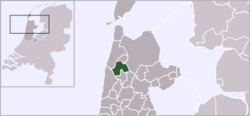
Harenkarspel
| Harenkarspel | |||
|---|---|---|---|
| Former municipality | |||
 | |||
| |||
 | |||
| Coordinates: 52°44′N 4°45′E / 52.73°N 4.75°ECoordinates: 52°44′N 4°45′E / 52.73°N 4.75°E | |||
| Country | Netherlands | ||
| Province | North Holland | ||
| Municipality | Schagen | ||
| Area(2006) | |||
| • Total | 54.83 km2 (21.17 sq mi) | ||
| • Land | 54.03 km2 (20.86 sq mi) | ||
| • Water | 0.80 km2 (0.31 sq mi) | ||
| Population (1 January 2007) | |||
| • Total | 15,922 | ||
| • Density | 295/km2 (760/sq mi) | ||
| Source: CBS, Statline. | |||
| Time zone | UTC+1 (CET) | ||
| • Summer (DST) | UTC+2 (CEST) | ||
| Website | www.harenkarspel.nl | ||


Harenkarspel (![]()
Population centres
The former municipality of Harenkarspel consisted of the following villages: Dirkshorn, Eenigenburg, Groenveld, Kalverdijk, Kerkbuurt, Krabbendam, 't Rijpje, Schoorldam (partly), Sint Maarten, Stroet, Tuitjenhorn, Valkkoog, Waarland, and Warmenhuizen. The largest towns were Warmenhuizen and Tuitjenhorn. The town hall of Harenkarspel was located in Tuitjenhorn.
Local government
The municipal council of Harenkarspel consisted of 17 seats, which were divided as follows:
References
- Statistics are taken from the SDU Staatscourant
External links
| Wikimedia Commons has media related to Harenkarspel. |
This article is issued from
Wikipedia.
The text is licensed under Creative Commons - Attribution - Sharealike.
Additional terms may apply for the media files.