A4 road (Zimbabwe)
| A4 road | |
|---|---|
 | |
| Highway system | |
| Transport in Zimbabwe |

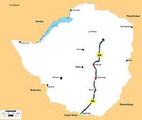
The A4 is a highway, also known as the R1 Highway runs between Beitbridge and Harare. From Beitbridge it passes through Rutenga, Ngundu, Masvingo, Mvuma, Chivhu before reaching Harare.
As a national road it is known as the A4 Highway and as a regional road corridor it is known as the R1 Highway.Source: [Map 9.2 Road Transport Network of Zimbabwe.][1]
Background
Pan African Highway Link
Together with the R3 Highway which runs from Harare to Chirundu, the R1 Highway is part of the North-South Corridor which is the Cairo-Cape Town Highway (Chirundu to Beitbridge 897 kilometres, 557 miles).[2][3]
The Trans-African Highway 4 is the road network being developed with the collaboration of the African Union, the United Nations Economic Commission for Africa and the African Development Bank. Its length is about 10,228 kilometers connecting Cairo and Cape Town. This Zimbabwean route is shorter by 150 kilometres (93 mi) than the route from Zambia through Botswana to South Africa. The R1 Highway is therefore a very important link taking the Trans-African Highway from Harare to Beitbridge where it continues into South Africa as N1 Highway.[4][5]
Rehabilitation
The highway is set for rehabilitation as part of the ongoing national roads project and as an important link to the Trans-African Highway.[6]
The R1 is the most direct link between the capital cities of Harare and Pretoria, and together with the R3 provide Zambia access to the Indian Ocean ports. The road carries between 1,000 and 5,000 vehicles per day, with the heavier flows in the proximity of Harare. It is therefore proper to rehabilitate this road. The Harare-Beitbridge road is part of the trunk road network of Zimbabwe, which is a part of the North-South Corridor – one of the major arterial links in the regional road network. The road is the most direct link between the capital cities of Harare and Pretoria, and provides landlocked Zambia access to the Indian Ocean ports of Durban and Richards Bay in South Africa.
Waypoints
Major way points are
Junctions
Junctions here are in North to South; Harare to Beitbridge order. These are major junctions only (trunk roads).
R6 Highway
The R Highway also known as the Chivhu-Nyazura Highway branches east from Chivhu.
R7 Highway
R7 Highway branches west at Mvuma to Gweru. Also called A17 or Gweru-Mvuma Road
A17 Gweru-Mvuma Road
P4/A9 Highway
A9 branches east at Masvingo to Mutare via Birchnough Bridge. P4 is part of the A9 that runs from Mutare to Mbalabala.
A9 Highway starts in Mutare city center as Herbert Chitepo Street at the intersect with Robert Mugabe Avenue which is the A3 Highway to Harare. ( 18°58′33″S 32°40′08″E / 18.975826°S 32.668915°E )
At the city end Herbert Chitepo Street adopts the name Chimanimani Road.
- As A9, the road begins in Mutare and goes through Nyanyadzi, Birchnough Bridge, Nyika, Masvingo, Mashava, Zvishavane, Filabusi then Mbalabala where it joins the (A6) Bulawayo-Beit Bridge Highway near the 61.5 km peg.[7]
P7/A9 Highway
Turns right at Masvingo to Mbalabala via Mashava. It also part of the national route called A9 that starts at Mutare and ends at Mbalabala via Masvingo. Mutare to Masvingo is primary road P4 while the Masvingo to Mbalabala part is primary road P7 but still A9 highway.
P5/A10 Highway
A10 branches east at Ngundu to Chiredzi through to Tanganda.
A10 Ngundu-Triangle-Chiredzi-Chisumbanje-Chimanimani Road
R8 Highway
R branches east at Rutanga to Sango via Mbizi
See also
References
- ↑ African Development Bank | Chapter 9: Road Transport Services and Infrastructure -African African Development Bank|Documents|Retrieved 25 March 2016
- ↑ "Chirundu Border Post Crossing Zimbabwe Zambia - ZIMBABWE TOURIST ATTRACTIONS-Zim News-Travel Advice". ZimGuide.com. Retrieved 22 May 2017.
- ↑ Simon. Corridor News 7 July 2014 from the African Infrastructure Programme | Transport World Africa|Rehabilitation of the Serenge Nakonde Road will involve widening of the road, and its improvement will contribute to cost reduction for road transportation along the North-South and Dar es Salaam Corridors, as well as reduce accident losses for the transport of passengers and goods. Ultimately, it is expected to improve the competitiveness of business in the eight countries that share the North-South Corridor – Botswana, DRC, Malawi, Mozambique, South Africa, Tanzania, Zambia and Zimbabwe. Project completion is expected by 2017. Transport World Africa|Retrieved 28 March 2016
- ↑ Tristan. "North-South corridor Africa's main vein - Transport World Africa". TransportWorldAfrica.co.za. Retrieved 22 May 2017.
- ↑ "Cairo-Cape Town Highway: From Vision to Reality in 2015". EgyptianStreets.com. 12 September 2014. Retrieved 22 May 2017.
- ↑ 28 January 2016 starts Harare-Beitbridge road dualisationprocess| Transport minister Joram Gumbo says government is restarting the dualisation of the Beitbridge-Harare-Chirundu road and rehabilitation of the country's border posts. The minister said the move had been necessitated by the problems encountered on the Plumtree-Harare highway and other issues the State had overlooked, which led to the cancellation of an earlier tender. Harare24|News|Retrieved 30 March 2016
- ↑ route from Filabusi, Zimbabwe to Masvingo, Zimbabwe|Filabusi, Zimbabwe: Head northeast 4.8 km: Turn right onto A9 85.5 km: Turn left to stay on A9 94.4 km: Turn right onto A4/A9 0.9 km: Turn left onto Rhus Ave 0.2 km: Turn right 0.3 km Masvingo, Zimbabwe Route Planner|Car route|Retrieved 20 2016
- ↑ Directions to Filabusi distance|Head east on Harare Rd/A5 towards Cecil Ave 0.2 km: 2.Turn right onto Cecil Ave 3.4 km: 3.Slight left towards Gwanda Rd/A6 0.2 km: 4.Merge onto Gwanda Rd/A6; Continue to follow A6 61.1 km: 5.Turn left onto A9, 25.6 km: 6.Turn right 4.6 km Filabusi, Zimbabwe Distance4.com|Directions|Retrieved 20 2016