Tilton on the Hill
| Tilton on the Hill | |
|---|---|
 Tilton on the Hill Tilton on the Hill shown within Leicestershire | |
| Population | 601 (2011) |
| OS grid reference | SK 742 057 |
| • London | 85.2 mi (137.1 km) South |
| Civil parish |
|
| District | |
| Shire county | |
| Region | |
| Country | England |
| Sovereign state | United Kingdom |
| Post town | LEICESTER |
| Postcode district | LE7 |
| Dialling code | 0116 |
| Police | Leicestershire |
| Fire | Leicestershire |
| Ambulance | East Midlands |
| EU Parliament | East Midlands |
| UK Parliament | |
Tilton on the Hill is a village in the civil parish of Tilton on the Hill and Halstead in the Harborough district of Leicestershire. The population of the civil parish at the 2011 census was 601.[1] It lies 2 miles north of the A47, on the B6047 to Melton Mowbray. Halstead civil parish (grid reference SK750056) was merged with Tilton in 1935, while the deserted medieval village of Whatborough (SK772059) was merged in 1994. Marefield remains a separate civil parish, but is part of the Tilton Electoral Ward.[2] St Peter's Tilton, the Parish Church is in the parish of Halstead, as is the vicarage.
Tilton on the Hill is one of the highest places in East Leicestershire at 719 feet (219 m) above sea level, with the Mill House standing at the highest point. Whatborough is the highest summit in the eastern half of the county. The centre of the village was designated a Conservation Area in 1975, with the boundaries updated in 1994 and 2005.[3]
In 2009, the village was named as the "Best Village in Leicestershire" in the Calor Village of the Year competition and also won Calor "Sustainability Village of the Year" for the Midlands.[4]
Tilton is represented in cricket by Tilton and Lowesby CC. Rob Welsh is currently the captain.
Services
The village has one public house called the Rose & Crown and one general store. The village is served by Kyriacou's Fish 'n' Chip van twice a week.[5]
The Village Hall stands near the centre of the village.[6]
The village's post office was replaced by an 'Outreach Service' in 2008, serving the village in the village hall on Monday and Wednesday afternoons 1.30 - 4.15pm
Tilton railway station on the Great Northern Railway was closed to passengers in 1953. The line continued to be used for freight for another ten years,mostly to take ore away from the iron ore quarry, which closed in 1961.[7] The railway cutting is a Geological Site of Special Scientific Interest and is owned and managed by the Leicestershire and Rutland Wildlife Trust.
Churches
There are two churches in Tilton on the Hill: St Peter's Tilton on the Hill (Church of England) and Halstead Methodist Chapel.
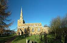
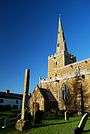
St Peter's Church
The first known mention of a religious establishment in Tilton is a reference in the Domesday Book to a priest. Much of the current church dates to the 13th and 14th Century and is a landmark for miles around. In 1854 substantial restoration work was carried out, overseen by R.C. Hussey, which led to the removal of the gallery at the west end of the church, as well as the medieval chancel screen. New roofs were installed but the bosses and corbelheads are thought to be 15th century originals,[8] Also installed in 1854 were new flooring, pulpit, reading desk and open benches. The total cost was £1200.[9] In 2014 the Church undertook a £193,000 repair of the bell-tower and spire.[10]
St Peter's contains the tombs of Sir Johan de Diggebye and his wife, dated 1269.[11] The tomb of Sir Everard Digby is dated 1509. In the Churchyard there is a medieval cross and the village memorial to those killed in World War I.[12]
Halstead Methodist Chapel
A Methodist Society began in Halstead in 1811,[13] and the Wesleyan chapel was built in 1813 on land let on a 99-year lease by T. Sikes esq. for a nominal 3 peppercorn rent. The chapel was enlarged in 1852,[14] and a plaque on the front marks a further extension in 1866. It was renovated internally in the late 1980s. In the 19th century it was part of the Stamford and Rutland Circuit.[15] It is now in the Leicester Trinity Methodist Circuit.[16]
Scheduled Ancient Monuments
There are 5 Scheduled Ancient Monuments in Tilton parish:[17]
| Image | S.A.M. Number | S.A.M. Description | coordinates & Grid reference |
|---|---|---|---|
 |
17014 | Moated site beside Loddington Road, Tilton. A square house platform with some grass-covered stonework, now heavily overgrown, is surrounded by a broad moat, water filled on the eastern side.[18] | 52°38′21″N 0°54′00″W / 52.6393°N 0.90005°W SK74530519 |
| 105 | Churchyard Cross. A 13th century cross base and shaft standing 2.4 metres (7.9 ft) high, in its original position in St Peter's churchyard.[19] | 52°38′35″N 0°54′12″W / 52.64306°N 0.903353°W SK743056 | |
| 106 | Mound 220yds north-west of church, thought to be a mound for a windmill of either medieval or post-medieval date.[20] | 52°38′43″N 0°54′16″W / 52.64532°N 0.904331°W SK74230585 | |
 |
186 | Defended enclosure on Robin-a-Tiptoe Hill of some 4.5 hectares (11 acres), possibly an Iron Age enclosure although the dating is uncertain.[21] | 52°37′48″N 0°51′33″W / 52.6301°N 0.8593°W SK773042 |
 |
17090 | Whatborough deserted medieval village[22] | 52°38′44″N 0°51′40″W / 52.6456°N 0.86102°W SK77160593 |
St Peter's Church is grade I listed, while a further 18 buildings are grade II listed[23]
Quarrying
Iron Ore was quarried to the east of Halstead on the north side of the Oakham Road between 1880 and about 1900, between 1912 and 1921 and between 1924 and 1961. Between 1880 and 1950 the quarries were on the west side of railway and from 1950 to 1961 on the east side. At first the ore was taken by standard gauge tramway to a tipping stage north of Tilton station where it was tipped into railway wagons in sidings. Horses pulled wagons on the tramway. From 1912 a narrow gauge tramway was used, still with horse haulage. Steam locomotives replaced the horses in 1928 which operated until 1950 . When the new quarries in the east of the railway were opened in that year and the old tramway closed, the ore was taken to the tipping dock by lorries which crossed over the railway by a new Bailey Bridge. Quarrying was done by hand with the aid of explosives until 1933 when a petrol parafin machine was brought in. From 1936 diesel machines were used. [24]
The main visible remains of the quarry operation are the final gullet on the west side (dating from 1950) near Halstead House,the tipping dock, the supports of the former Bailey bridge and traces of the lorry road leading to it.[25]
References
- ↑ "Civil Parish population 2011". Neighbourhood Statistics. Office for National Statistics. Retrieved 22 June 2016.
- ↑ Harborough District Council Wards Archived 13 June 2011 at the Wayback Machine. retrieved 3 January 2009
- ↑ Tilton Conservation Area: Proposed Boundary Changes: 2005 Archived 13 August 2011 at the Wayback Machine. Harborough District Council
- ↑ This is Leicestershire 28 September 2009
- ↑ Kyriacou's Family Fish & Chip Van
- ↑ Tilton Village Hall Archived 27 January 2010 at the Wayback Machine.
- ↑ Tonks, Eric (1992). The Ironstone Quarries of the East Midlands Part 9 Leicestershire. Cheltenham: Runpast Publishing. p. 220. ISBN 1-870754-08-5.
- ↑ Listed Building Description for Church of St Peter, Tilton on the Hill.
- ↑ History, Gazetteer and Directory of the Counties of Leicestershire and Rutland, William White. Published 1863
- ↑ tiltonchurch.co.uk, accessed 28 April 2014
- ↑ St Peter's Church guide
- ↑ tiltononthehill.org.uk/tiltonwarmemorial.asp, accessed 28 April 2014
- ↑ Leicestershirevillages.com Halstead Methodist Chapel, accessed 28 April 2014
- ↑ History, Gazetteer and Directory of the Counties of Leicestershire and Rutland, William White. Published 1863
- ↑ History of the Stamford and Rutland Methodist Circuit, accessed 28 April 2014
- ↑ Leicester Trinity Circuit locations: Halstead Archived 30 April 2014 at the Wayback Machine.
- ↑ Harborough Scheduled Ancient Monuments, Appendix C
- ↑ pastscape.org.uk: Tilton Moated Site accessed 29 April 2014
- ↑ pastscape.org.uk: Tilton Churchyard Cross. MONUMENT NUMBER: 321170
- ↑ pastscape.org.uk MONUMENT NO. 321179, Flat-topped mound accessed 26 April 2014
- ↑ Pastscape.org.uk Robin-a-Tiptoe. MONUMENT NUMBER: 321225 Archived 29 April 2014 at the Wayback Machine. accessed 26 April 2014
- ↑ Pastscape.org.uk Whatborough Deserted Village. MONUMENT NUMBER: 321112 accessed 7 August 2017
- ↑ Heritage Gateway Listed Buildings online
- ↑ Tonks, Eric (1992). The Ironstone Quarries of the Midlands Part 9: Leicestershire. Cheltenham: Runpast. pp. 209–223. ISBN 1-870754-08-5.
- ↑ Tonks: pages 221-2
External links
| Wikimedia Commons has media related to Tilton on the Hill. |
- Tilton on the Hill with information on the genealogy of Tilton.
- Phillimore's Marriage Index
- Tilton Church official website.
- The Rose & Crown pub at the centre of the village for over 300 years
- 2001 Census Tilton Parish Profile
- Leicestershire Villages community website with information on local organisations and activities.
- Parish Walks for Tilton on the Hill
Accommodation
- Hedgehog Hall Luxury Bed & Breakfast accommodation
- Three Cottages Bed & Breakfast accommodation