Richat Structure
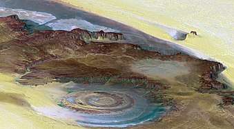
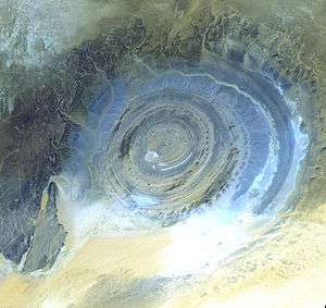
The Richat Structure or Guelb er Richât (Arabic قلب الريشات Qalb ar-Rīšāt), also dubbed the "Eye of Africa",[1] or "Eye of the Sahara"[2] is a prominent circular feature in the Sahara's Adrar Plateau, near Ouadane, west–central Mauritania.
Description
The Richat Structure is a deeply eroded, slightly elliptical dome with a diameter of 40 kilometres (25 mi). The sedimentary rock exposed in this dome ranges in age from Late Proterozoic within the center of the dome to Ordovician sandstone around its edges. The sedimentary rocks comprising this structure dip outward at 10–20°. Differential erosion of resistant layers of quartzite has created high-relief circular cuestas. Its center consists of a siliceous breccia covering an area that is at least 30 kilometres (19 mi) in diameter.[3][4][5]
Exposed within the interior of the Richat Structure are a variety of intrusive and extrusive igneous rocks. They include rhyolitic volcanic rocks, gabbros, carbonatites and kimberlites. The rhyolitic rocks consist of lava flows and hydrothermally altered tuffaceous rocks that are part of two distinct eruptive centers, which are interpreted to be the eroded remains of two maars. According to field mapping and aeromagnetic data, the gabbroic rocks form two concentric ring dikes. The inner ring dike is about 20 m in width and lies about 3 km from the center of Richat Structure. The outer ring dike is about 50 m in width and lies about 7 to 8 km from the center of this structure. Thirty-two carbonatite dikes and sills have been mapped within the Richat Structure. The dikes are generally about 300 m long and typically 1 to 4 m wide. They consist of massive carbonatites that are mostly devoid of vesicles. The carbonatite rocks have been dated as having cooled between 94 and 104 million years ago. A kimberlitic plug and several sills have been found within the northern part of the Richat Structure. The kimberlite plug has been dated to around 99 million years old. These intrusive igneous rocks are interpreted as indicating the presence of a large alkaline igneous intrusion that currently underlies the Richat Structure and created it by uplifting the overlying rock.[3][4][6][7]
Spectacular hydrothermal features are a part of the Richat Structure. They include the extensive hydrothermal alteration of rhyolites and gabbros and a central megabreccia created by hydrothermal dissolution and collapse. The siliceous megabreccia is at least 40 m thick in its center to only a few meters thick along its edges. The breccia consists of fragments of white to dark gray cherty material, quartz-rich sandstone, diagenetic cherty nodules, and stromatolitic limestone and is intensively silicified. The hydrothermal alteration, which created this breccia, has been dated to have occurred about 98.2 ± 2.6 million years ago using the 40Ar/39Ar method.[3][4][7]
Interpretation
The Richat structure is regarded by geologists as a highly symmetrical and deeply eroded geologic dome. It was first described in the 1930s to 1940s, as Richât Crater or Richât buttonhole (boutonnière du Richât). Richard-Molard (1948) considered it to be the result of a laccolithic thrust.[8] A geological expedition to Mauretania led by Théodore Monod in 1952 recorded four "crateriform or circular irregularities" (accidents cratériformes ou circulaires) in the area, Er Richât, Aouelloul (south of Chinguetti), Temimichat-Ghallaman and Tenoumer.[9] Origin of Er Richât as an impact structure (as is clearly the case with the other three) was briefly considered, but closer study in the 1950s to 1960s suggested that it was formed by terrestrial processes. After extensive field and laboratory studies in the 1960s, no credible evidence has been found for shock metamorphism or any type of deformation indicative of a hypervelocity extraterrestrial impact.[10] While coesite, an indicator of shock metamorphism, had initially been reported as being present in rock samples collected from the Richat Structure, further analysis of rock samples concluded that barite had been misidentified as coesite.[11]
Work on dating the structure was done in the 1990s.[12] Renewed study of the formation of the structure by Matton et al. (2005) and Matton (2008) confirmed the conclusion that it is not an impact structure. The circular distribution of ridges and valleys is explained as the formation of cuestas by the differential erosion of alternating hard and soft rock layers uplifted as a dome by an underlying alkaline igneous complex of Cretaceous age.[13]
A 2011 multianalytical study on the Richat megabreccias concluded that carbonates within the silica-rich megabreccias were created by low-temperature hydrothermal waters, and that the structure requires special protection and further investigation of its origin.[14]
References
- ↑ Matton 2008, p. 31.
- ↑ Bartels, Meghan (12 July 2016). "Scientists still have questions about the mysterious Eye of the Sahara". Business Insider. Retrieved 3 October 2018.
- 1 2 3 Matton, G. (2008). "The Cretaceous Richat Complex (Mauritania); a peri-Atlantic alkaline" (PDF). Chicoutimi, Quebec, Canada: Université du Québec à Chicoutimi.
- 1 2 3 Matton, Guillaume; Jébrak, Michel; Lee, James K.W. (2005). "Resolving the Richat enigma: Doming and hydrothermal karstification above an alkaline complex". Geology. 33 (8): 665–68. doi:10.1130/G21542AR.1.
- ↑ Woolley, A. R. (2001) Alkaline Rocks and Carbonatites of the World, Part 3: Africa. London, United Kingdom, The Geological Society of London. ISBN 978-0-412-61410-1
- ↑ Netto, A. M., J. Fabre, J., G. Poupeau, and M. et Champemmois (1992) Datations par traces de fissions de la structure circulaire des Richats.Comptes Rendus de 'Académie des Sciences. v. 314, pp. 1179–86.
- 1 2 Matton, G., and M. Jébrak (2014) The "eye of Africa" (Richat dome, Mauritania): An isolated Cretaceous alkaline–hydrothermal complex Journal of African Earth Sciences. v. 97, no. 8, pp. 109–24.
- ↑ Jacques Richard-Molard, La boutonnière du Richât en Adrar Mauritanien Acad. Sci. Comptes Rendus, vol. 227, 142f.
- ↑ Notes africaines, Issues 109-124 (1966), p. 32.
- ↑ Dietz, R. S., R. Fudali, and W. Cassidy (1969) Richat and Semsiyat Domes (Mauritania): Not Astroblemes. Geological Society of America. v. 80, no. 7, pp. 1367–72.
- ↑ Fudali, R. F. (1969) Coesite from the Richat Dome, Mauritania: A Misidentification. Science. v. 166, no. 3902, pp. 228–30.
- ↑ Netto, A.M., Fabre, J., Poupeau, G., and Champemmois, M., 1992, "Datations par traces de fissions de la structure circulaire des Richats" Paris, Acad. Sci. Comptes Rendus, vol. 314, p. 1179–1186. Poupeau, G., Fabre, J., Labrin, E., Azdimoussa, A., Netto, A.M., and Monod, T., 1996, "Nouvelles datations par traces de fission de la structure circulaire des Richat (Mauritanie)": Mémoires du Service Géologique de l’Algérie, vol 8, p. 231–236.
- ↑ "The breccia core is genetically related to plutonic activity, since doming and the production of hydrothermal fluids were instrumental in creating a favorable setting for dissolution. The resulting fluids were also responsible for subsequent silicification and hydrothermal infilling. To the best of our knowledge, karst collapse phenomena at the summit of an alkaline complex are unique, but may be more frequent than previously believed." (Matton 2005)
- ↑ Martinez-Frias, J., Rull, F., Martín-Redondo, M. P., Delgado, A., Fernández-Sampedro, M. T., García-Talavera, F., López-Vera, F. and Menor Salván, C. (2011) Multianalytical characterization of silica-rich megabreccias from the proposed natural area of Richat (Sahara desert, Mauritania). Research Journal of Chemistry and Environment v. 15, no. 3, pp. 49–54.
External links
| Wikimedia Commons has media related to Richat Structure. |
- Anonymous (nd) Richat Structure, Mauritania NASA Earth Observatory
- Anonymous (nd) Earth’s Bulls-Eye, the Eye of Africa, Landmark for Astronauts. Love These Pics
- Nemiroff, R., and J. Bonnell (2002) Earth's Richat Structure, Astronomy Picture of the Day, October 28, 2002. Astronomy Picture of the Day, Michigan Technological University, Houghton, Michigan.
- Découverte - L'énigme de Richat (French), a video documentary from Radio Canada.