Gsengetstein
| Gsengetstein | |
|---|---|
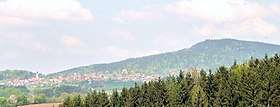 The Gsengetstein and village of Kirchdorf im Wald | |
| Highest point | |
| Elevation | 951 m (3,120 ft) |
| Coordinates | 48°55′54″N 13°15′29″E / 48.9318°N 13.2581°ECoordinates: 48°55′54″N 13°15′29″E / 48.9318°N 13.2581°E |
| Geography | |
 Gsengetstein | |
| Parent range | Bavarian Forest |
| Geology | |
| Type of rock | Gneiss |
The Gsengetstein (951 m) is one of the smaller mountains in the Bavarian Forest, rising from in a less-frequented mountain ridge between the villages of Rinchnach, Kirchdorf im Wald and Frauenau.
A large summit cross stands on its craggy summit, which has views towards the southwest. Although the Gsengetstein rises immediately above the busy B 85 federal road, it is rarely visited and is thus an idyllic rest area. The mountain may be ascended from Kirchdorf im Wald, Schlag, Ried or Gehmannsberg near the well known church of Frauenbrünnl.
This article is issued from
Wikipedia.
The text is licensed under Creative Commons - Attribution - Sharealike.
Additional terms may apply for the media files.