Greater Caucasus
| Greater Caucasus | |
|---|---|
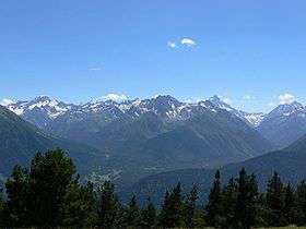 Mountainous landscape of Arkhyz | |
| Highest point | |
| Peak | Mount Elbrus |
| Elevation | 5,642 m (18,510 ft) |
| Coordinates | 43°21′18″N 42°26′31″E / 43.35500°N 42.44194°ECoordinates: 43°21′18″N 42°26′31″E / 43.35500°N 42.44194°E |
| Dimensions | |
| Length | 1,200 km (750 mi) NW-SE |
| Geography | |
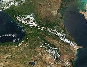 Satellite image
| |
| Countries | Azerbaijan, Georgia and Russia |
| Parent range | Caucasus Mountains |
| Borders on | Lesser Caucasus |
Greater Caucasus (Azerbaijani: Böyük Qafqaz, Бөјүк Гафгаз, بيوک قافقاز; Georgian: დიდი კავკასიონი, Didi K’avk’asioni; Russian: Большой Кавказ, Bolshoy Kavkaz, sometimes translated as "Caucasus Major", "Big Caucasus" or "Large Caucasus") is the major mountain range of the Caucasus Mountains.
The range stretches for about 1,200 kilometres (750 mi) from west-northwest to east-southeast, between the Taman Peninsula of the Black Sea to the Absheron Peninsula of the Caspian Sea: from the Western Caucasus in the vicinity of Sochi on the northeastern shore of the Black Sea and reaching nearly to Baku on the Caspian.
The range is traditionally separated into three parts:
- Western Caucasus, from the Black Sea to Mount Elbrus
- Central Caucasus, from Mount Elbrus to Mount Kazbek
- Eastern Caucasus, from Mount Kazbek to the Caspian Sea
In the wetter Western Caucasus, the mountains are heavily forested (deciduous forest up to 1,500 metres (4,900 ft), coniferous forest up to 2,500 metres (8,200 ft) and alpine meadows above the tree line). In the drier Eastern Caucasus, the mountains are mostly treeless.
Europe—Asia boundary
The watershed of the Caucasus is also considered the boundary between Eastern Europe and Western Asia. The European part north of the watershed is known as Ciscaucasia, the Asiatic part to the south as Transcaucasia, which is dominated by the Lesser Caucasus mountain range and whose western portion converges with Eastern Anatolia.[1]
The border of Russia with Georgia and Azerbaijan runs along the most of the Caucasus' length. The Georgian Military Road (Darial Gorge) and Trans-Caucasus Highway traverse this mountain range at altitudes of up to 3,000 metres (9,800 ft).
Watershed
The watershed of the Caucasus was the border between the Caucasia province of the Russian Empire in the north and the Ottoman Empire and Persia in the south in 1801, until the Russian victory in 1813 and the Treaty of Gulistan which moved the border of the Russian Empire well within Transcaucasia.[2] The border between Russia and Georgia still follows the watershed almost exactly (except for Georgia's western border, which extends south of the watershed, and except for a narrow strip of territory in northern Mtskheta-Mtianeti and northwestern Kakheti where Georgia extends north of the watershed), while Azerbaijan in its northeastern corner has five districts north of the watershed (Davachi, Khachmaz, Qusar, Siazan, Quba).
Peaks

- Mount Elbrus, 5,642 m (18,510 ft), 43°21′18″N 42°26′21″E / 43.35500°N 42.43917°E is the highest mountain in Europe.
- Dykh-Tau, 5,205 m (17,077 ft), 43°3′N 43°8′E / 43.050°N 43.133°E
- Shkhara, 5,201 m (17,064 ft), 43°01′N 43°10′E / 43.01°N 43.17°E
- Koshtan-Tau, 5,151 m (16,900 ft), 43°03′00″N 43°13′00″E / 43.05°N 43.2167°E
- Shota Rustaveli Peak, 4,859 m (15,942 ft), 43°01′33″N 43°02′37″E / 43.02592°N 43.04349°E
- Kazbek, 5,047 m (16,558 ft), 42°41′51″N 44°31′08″E / 42.69750°N 44.51889°E
- Tebulosmta, 4,493 m (14,741 ft), 42°38′N 45°19′E / 42.64°N 45.32°E
- Diklosmta, 4,285 m (14,058 ft), 42°33′N 45°48′E / 42.55°N 45.80°E
- Bazardüzü, 4,466 m (14,652 ft), 41°16′N 47°47′E / 41.27°N 47.79°E
- Babadag, 3,629 m (11,906 ft), 41°03′N 48°17′E / 41.05°N 48.29°E
- Katyn-Tau, 4,979 m (16,335 ft), 43°01′50″N 43°02′08″E / 43.03069°N 43.03555°E
- Pushkin, 5,033 m (16,512 ft), 43°00′51″N 43°04′12″E / 43.01422°N 43.07001°E
- Janga, 5,051 m (16,572 ft), 43°01′08″N 43°03′24″E / 43.01889°N 43.05671°E
- Tetnuld, 4,858 m (15,938 ft), 43°01′52″N 42°59′35″E / 43.03113°N 42.99319°E
- Ushba, 4,710 m (15,450 ft), 43°07′29″N 42°39′32″E / 43.12486°N 42.65901°E
- Ailama, 4,525 m (14,846 ft), 42°57′29″N 43°10′43″E / 42.95806°N 43.17861°E
Passes
- Darial Pass
- Marukhis Ugheltekhili 43°23′N 41°22′E / 43.38°N 41.37°E)
- Pereval Klukhorskiy 2,786 m (9,140 ft), 43°16′N 41°48′E / 43.26°N 41.80°E
- Mamison Pass 2,820 m (9,250 ft), 42°43′N 43°48′E / 42.72°N 43.80°E
- Jvris Ugheltekhili 2,379 m (7,805 ft), 42°30′N 44°27′E / 42.50°N 44.45°E
- Dübrar Pass 2,209 m (7,247 ft), 40°58′N 48°38′E / 40.96°N 48.63°E
References
| Wikimedia Commons has media related to Greater Caucasus. |
- ↑ 18th-century definitions drew the boundary north of the Caucasus, across the Kuma–Manych Depression. This definition remained in use in the Soviet Union during the 20th century. In western literature, the continental boundary has been drawn along the Caucasus watershed since at least the mid 19th century. See e.g. Baron von Haxthausen, "Transcaucasia" (1854); review Dublin university magazine Douglas W. Freshfield, "Journey in the Caucasus", Proceedings of the Royal Geographical Society, Volumes 13-14, 1869.
- ↑ Encyclopædia Britannica o 1833, vol 5, p. 251.
| |||||||||||||||||