Great Wicomico River Light
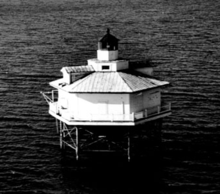 Undated photograph of Great Wicomico River Light (USCG) | |
 | |
| Location | Mouth of the Great Wicomico River |
|---|---|
| Coordinates | 37°48′15″N 76°16′03″W / 37.8042°N 76.2675°WCoordinates: 37°48′15″N 76°16′03″W / 37.8042°N 76.2675°W |
| Year first lit | 1889 |
| Deactivated | 1967 |
| Foundation | screw-pile |
| Construction | cast-iron/wood |
| Tower shape | hexagonal house |
| Height | 42 feet (13 m) |
| Original lens | fourth-order Fresnel lens |
| Range | 6.1 nautical miles; 11 kilometres (7 mi) |
| Characteristic | Flashing 6 sec |
The Great Wicomico River Light was a lighthouse located at the mouth of the Great Wicomico River, south of the Potomac River on the western side of the Chesapeake Bay. It was first lit in 1889 and was deactivated in 1967.
References
- "Historic Light Station Information and Photography: Virginia". United States Coast Guard Historian's Office.
- Great Wicomico River Light, from the Chesapeake Chapter of the United States Lighthouse Society
- de Gast, Robert (1973). The Lighthouses of the Chesapeake. Johns Hopkins University Press. p. 155.
This article is issued from
Wikipedia.
The text is licensed under Creative Commons - Attribution - Sharealike.
Additional terms may apply for the media files.