Great Lakes Megalopolis
| Great Lakes Megalopolis | |
|---|---|
| Megaregion of the U.S. and Canada | |
 Chicago | |
 Toronto | |
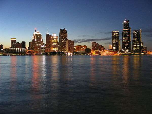 Detroit | |
| Countries |
|
| States |
|
| Provinces |
|
| Largest city |
|
| Largest metropolitan area |
|
| Population | 59,144,461 |
The Great Lakes Megalopolis consists of the group of metropolitan areas in North America largely in the Great Lakes region and along the Saint Lawrence Seaway. To its south and west, it lies in the Midwestern United States, extending east into western Pennsylvania and Upstate New York, as well as north to Southern Ontario and the southern part of Quebec in Canada. It is the largest and most populated megalopolis in North America.
At its most inclusive, the region cuts a wide swath from the Twin Cities in Minnesota to Pittsburgh and Rochester, New York. On the Canadian side, it extends as far east as Quebec City. Further south, the region is commonly considered to include St. Louis, Kansas City, Cincinnati, Indianapolis, Louisville, Kentucky, and Columbus, Ohio. Within this broad region, there is a smaller core area that includes Chicago, Milwaukee, Detroit, Cleveland, and Pittsburgh. The larger region, including fringe areas, had an estimated population of 59,144,461 as of 2011. It is projected to reach a population of approximately 65 million by 2025.
There is substantial overlap between the broader megalopolis and the once-heavily industrialized region known as the Rust Belt; however, the Great Lakes megalopolis and the Rust Belt terms are not interchangeable, as some metropolitan areas may be considered part of one region but not the other.
History of the concept
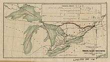
The region was partially outlined as an emergent megalopolis in the 1961 book Megalopolis: The Urbanized Northeastern Seaboard of the United States by French geographer Jean Gottmann. Gottmann envisaged the development of other megalopolies in the U.S.: from Boston to Washington, D.C., from Chicago to Pittsburgh, and from San Francisco to San Diego. In 1965, Herman Kahn speculated about the future of the three megalopoleis in the year 2000,[2] and not mentioning geographer Gottmann. In the 1960s and 1970s, urban planner and architect Constantinos Doxiadis authored books, studies, and reports including those regarding the growth potential of the Great Lakes Megalopolis.[3] Doxiadis envisioned Detroit as the central urban area in the Great Lakes Megalopolis, however, that is far and beyond Chicago. According to him, the megalopolis extended "from Milwaukee and Chicago to Detroit, Pittsburgh and Buffalo and into Canada from Windsor to Montreal and Quebec."[3][4]
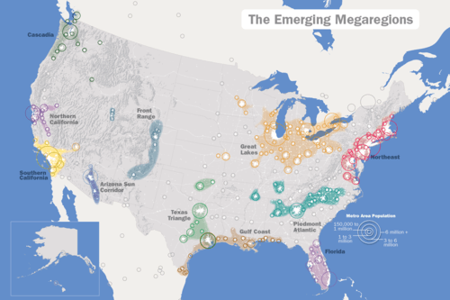
In 2005, the Virginia Tech Metropolitan Institute's Beyond Megalopolis, an attempt to update Gottmann's work, outlined a similar "Midwest" megapolitan area as one of ten such areas in the United States (Canada is discussed tangentially).[5] Over 200 million tons of cargo are shipped annually through the Great Lakes.[6][7][8] Half the US's population growth and two-thirds of its economic growth is expected to occur within the megaregions over the next four decades. The America 2050 project has identified eleven Megaregions of the United States, including the Great Lakes Megalopolis.[9][A] The Canadian part of the region is also referred to as the Quebec City–Windsor Corridor.
Governments
There are multiple government jurisdictions throughout the megalopolis. In addition to Canada and the United States, two Canadian provinces and multiple U.S. states have jurisdiction, and there are many municipal governments. Most of the states have joined the provinces in forming the Conference of Great Lakes and St. Lawrence Governors and Premiers to coordinate economic and environmental strategies throughout most of the region.[10]
Economy
According to the Brookings Institution, if it stood alone as a country, the economy of the Great Lakes region which includes most of the Great Lakes Megalopolis, would be one of the largest economic units in the world (with a $4.5-trillion gross regional product), roughly equal to that of Japan. The five Great Lakes contain one-fifth of the world's surface fresh water and have a combined shoreline of 10,210 miles (17,017 km). About 200 million tons of cargo are shipped by way of the Great Lakes each year.[7][11][12]
Tourism is an important economic factor in and around the Great Lakes. The Great Lakes Cruising Coalition supports passenger ship cruises through a joint U.S-Canadian venture to Great Lakes Ports and the Saint Lawrence Seaway.[13][14]
The Chicago metropolitan area (also called Chicagoland) has one of the world's largest and most diverse economies. The Chicago metro area is the fourth largest city economy globally, after the metro areas of Tokyo, New York City, and Los Angeles, and ranking ahead of London and Paris. At 9.8 million people, the Chicago metropolitan area will become the Great Lakes region's first mega-city and the United States' third megacity. Globally, a megacity is defined as a city with a Combined Statistical Area (CSA) metro population of at least ten million people.
Major land and marine transportation corridors
The Great Lakes Megalopolis includes the following major inter-urban corridors that are provided with freeway and passenger rail service in both the core and fringe areas of the mega-region. Major waterways for shipping and cruising are also indicated where applicable. Amtrak in the United States and Via Rail in Canada offer rail passenger service, while most Class I freight rail services also connect these areas. A major rail shipping service in both Canada and the United States is provided on tracks owned by Canadian National Railway Company.
Chicago-Minneapolis/St. Paul
This corridor occupies the northwestern fringe of the megalopolis. Interstate highway 94 (I-94) and Amtrak rail run roughly parallel from Chicago, IL to Minneapolis/St. Paul, MN by way of Milwaukee, WI and Madison, WI.
Chicago-St. Louis
I-55, Amtrak, and the Illinois Waterway connect Chicago, IL to St. Louis, MO.
Chicago-Indianapolis-Cincinnati
I-65 extends from the Chicago area southeast to Indianapolis IN, where I-74 travels through to Cincinnati, OH. Amtrak runs regular service along this same route.
Chicago-Rochester
I-90 and Amtrak run approximately parallel through the core area of the megalopolis from Chicago to Cleveland OH via South Bend IN and Toledo OH, then into the eastern fringe area comprising Buffalo and Rochester NY. Amtrak also has a passenger rail link from Cleveland to Pittsburgh PA which is roughly paralleled by I-76. The main water route deviates well to the north of the land route from Chicago to Detroit. It runs north along Lake Michigan, east through the Straits of Mackinac, then south along Lake Huron, the St. Clair River, and Lake St Clair to the Detroit River. From this point, the water route roughly parallels the land route to Rochester by way of Lake Erie, the Welland Canal, and Lake Ontario.
Chicago-Detroit
I-94 takes a more northerly route than I-90 through the megalopolis core area east of Chicago. It extends from that city to the west end of the Windsor-Quebec City Corridor by way of Kalamazoo, Ann Arbor, Detroit, and Port Huron MI/Sarnia ON. This interstate freeway is also paralleled by Amtrak rail service. The main water route is the same as for the western part of the Chicago-Rochester water corridor from Lake Michigan to the Detroit River.
Windsor-Quebec City
The core area of the Great Lakes megalopolis is often considered to extend as far north and east as Toronto on the Canadian side of the border. The remainder of the Windsor-Quebec City Corridor lies more along the northeastern fringe. The entire Canadian section of the megaregion is sometimes considered a separate megalopolis. Key freeways include Highway 401 and Highway 417 in Ontario which connect with Autoroute 20 and Autoroute 40 respectively in Quebec. Highway 416 and Autoroute 50 link the National Capital Region with Highway 401 and the Montreal area respectively, but the two freeways do not link directly with each other across the Ontario-Quebec border. Passenger rail service is provided in both provinces by Via Rail. Intermediate points along the corridor include London, Hamilton, Toronto, Kingston, Ottawa, and Montreal. The main water shipping route is the same as for the eastern part of the Chicago-Rochester corridor, starting at the Detroit River but continuing east beyond Lake Ontario along the St. Lawrence Seaway to Quebec City and the Gulf of St. Lawrence.
Secondary land or marine transportation corridors
Several corridors have interstate highways but no comprehensive passenger rail service. These highway routes pass through both core and fringe areas of the Great Lakes megalopolis. The upper Great lakes region has a marine corridor that connects Lakes Superior, Huron, and Michigan. However, this route does not include parallel Amtrak passenger rail or interstate highway service.
Kansas City-Pittsburgh
I-70 follows the southern fringe of the megaregion. It runs from Kansas City MO to just south of Pittsburgh PA by way of St. Louis MO, Indianapolis IN, and Columbus OH.
Detroit-Grand Rapids
Interstate 96 serves traffic between the Detroit and Grand Rapids metro areas. The route passes through Lansing on the way and extends to Muskegon to the northwest of Grand Rapids
Evansville-Indianapolis-Port Huron
I-69 extends from Evansville IN to Bloomington IN. From there, the route is temporarily an arterial highway, Indiana state route 37, to the I-465 ring-road around Indianapolis IN. From there, I-69 resumes and continues to the west end of the Windsor-Quebec City Corridor which carries the route into southern Ontario and southern Quebec provinces. Intermediate points include Fort Wayne IN, Lansing, Flint, and Port Huron MI/Sarnia ON.
Cincinnati-Saginaw
I-75 runs from Saginaw MI to Cincinnati OH by way of Detroit MI, Toledo OH, and Dayton OH.
Duluth-Lake Huron
The waterway connecting Duluth MN and western Lake Superior to points east and south includes the Soo Locks connecting to Lake Huron, then south to Port Huron MI/Sarnia ON or through the Straits of Mackinac to the metropolitan areas around Lake Michigan.
Selected American and Canadian population centers
| Rank | Area | State/ Province |
Image | CSA/CMA 2009 population |
Projected[15][16][17][18] 2025 population |
Projected increase 2009-2025 |
Projected % increase 2009-2025 |
|---|---|---|---|---|---|---|---|
| 1 | Chicago | Illinois Indiana Wisconsin |
 |
9,804,845 | 10,216,648 | 411,803 | 4.2 |
| 2 | Toronto | Ontario |  |
5,541,400 | 6,682,061 | 1,140,661 | 20.5 |
| 3 | Detroit | Michigan | 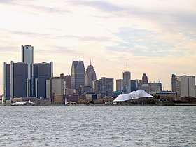 |
5,318,744 | 5,583,400 | 264,656 | 5.0 |
| 4 | Montreal | Quebec |  |
3,859,300 | 4,246,931 | 387,631 | 10.1 |
| 5 | Minneapolis – Saint Paul | Minnesota Wisconsin |
 |
3,604,460 | 4,031,000 | 426,540 | 11.8 |
| 6 | Cleveland – Akron – Canton | Ohio |  |
3,515,646 | 3,469,943 | -45,703 | -1.3 |
| 7 | St. Louis | Missouri Illinois |
 |
2,892,874 | 3,049,000 | 156,126 | 5.4 |
| 8 | Pittsburgh | Pennsylvania |  |
2,445,117 | 2,868,818 | 367,299 | 15.0 |
| 9 | Indianapolis | Indiana | .jpg) |
2,386,199 | 2,779,921 | 393,722 | 16.5 |
| 10 | Cincinnati | Ohio Kentucky Indiana |
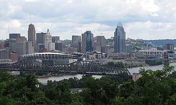 |
2,214,954 | 2,448,000 | 233,046 | 10.5 |
| 11 | Kansas City | Missouri Kansas |
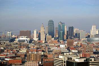 |
2,038,724 | 2,293,564 | 254,840 | 12.5 |
| 12 | Columbus | Ohio |  |
2,031,229 | 2,446,450 | 415,221 | 20.4 |
| 13 | Milwaukee | Wisconsin |  |
2,025,898 | 2,129,949 | 103,706 | 5.1 |
| 14 | Ottawa – Gatineau | Ontario Quebec |
 |
1,451,415 | 1,596,556 | 145,141 | 10.0 |
| 15 | Louisville | Kentucky Indiana |
 |
1,395,634 | 1,602,456 | 206,822 | 14.8 |
| 16 | Grand Rapids | Michigan |  |
1,327,366 | 1,530,000 | 202,634 | 15.3 |
| 17 | Buffalo | New York |  |
1,203,493 | 1,251,633 | 48,140 | 6 |
| 18 | Rochester | New York | 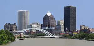 |
1,149,653 | 1,133,558 | -16,095 | -14.2 |
| 19 | Dayton | Ohio |  |
1,066,261 | 1,066,261 | 0 | 0 |
| 20 | Hamilton | Ontario | 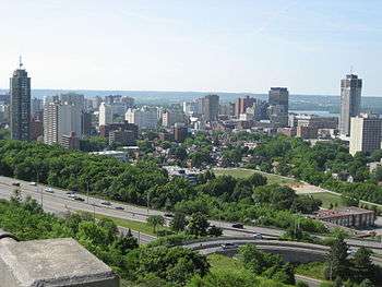 |
740,200 | 954,858 | 214,658 | 29.1 |
| 21 | South Bend-Mishawaka-Elkhart | Indiana Michigan |
720,647 | NA | NA | NA | |
| 22 | Toledo | Ohio Michigan |
672,220 | 672,220 | 0 | 0 | |
| 23 | Madison | Wisconsin |  |
628,947 | 820,483 | 191,563 | 30.5 |
| 24 | Youngstown-Warren-Boardman | Ohio Pennsylvania |
 |
602,964 | N/A | N/A | N/A |
| 25 | Kalamazoo | Michigan |  |
524,030 | NA | NA | NA |
| 26 | Lansing | Michigan | 523,609 | 547,325 | 23,716 | 4.6 | |
| 27 | Kitchener – Waterloo | Ontario | 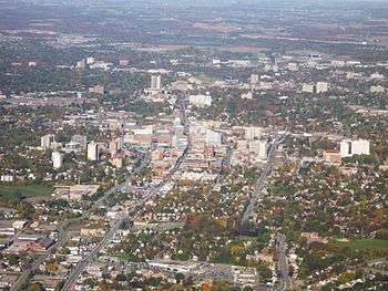 |
492,400 | 635,196 | 142,796 | 29.1 |
| 28 | London | Ontario | 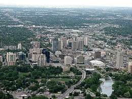 |
492,200 | 634,938 | 142,738 | 29.1 |
| 29 | Rockford | Illinois |  |
455,595 | 499,400 | 43,805 | 9.9 |
| 30 | Fort Wayne | Indiana |  |
414,315 | 455,623 | 39,366 | 9.9 |
| 31 | St. Catharines – Niagara | Ontario |  |
404,400 | 521,676 | 117,276 | 29.0 |
| 32 | Davenport-Rock Island-Moline | Iowa Illinois |
 |
379,690 | 452,565 | 72,875 | 26.1 |
| 33 | Fox Cities | Wisconsin |  |
360,000 | NA | NA | NA |
| 34 | Oshawa | Ontario |  |
356,177 | 419,067 | 62,890 | 17.7 |
| 35 | Windsor | Ontario | 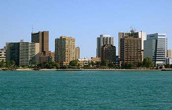 |
330,900 | 426,861 | 95,961 | 29 |
| 36 | Green Bay | Wisconsin |  |
304,783 | NA | NA | NA |
| 37 | Erie | Pennsylvania |  |
280,985 | N/A | N/A | N/A |
| 38 | Duluth-Superior | Minnesota Wisconsin |
 |
279,771 | N/A | N/A | N/A |
| Total CSA/CMA of major metro areas | 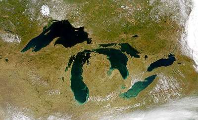 |
60,305,653 | 65,735,336 | 6,234,698 | 10.0 |
American census urban statistical areas
Along the Great Lakes, there are 27 United States statistical areas - 10 Combined Statistical Areas, 7 Metropolitan Statistical Areas (independent of the Combined Statistical Areas), and 3 Micropolitan Statistical Areas (independent of the Combined Statistical Areas), as defined by the Office of Management and Budget.
The following sortable table lists the 27 statistical areas of the United States located on the Great Lakes with the following information:
- The rank by population as of 2007-07-01, as estimated by the United States Census Bureau
- The census statistical area name as defined by the United States Census Bureau
- The census statistical area population as of 2007-07-01, as estimated by the United States Census Bureau
- Lakes within census statistical area
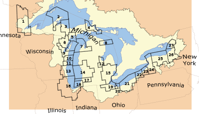
| Rank | Map Reference Number | Census Statistical Area | 2017 Population | Lake(s) |
|---|---|---|---|---|
| 1 | 16 | Chicago-Naperville-Michigan City, IL-IN-WI CSA | 9,745,165 | Lake Michigan |
| 2 | 15 | Detroit-Warren-Flint, MI CSA | 5,405,918 | Lake Erie and Lake Huron |
| 3 | 21 | Cleveland-Akron-Elyria, OH CSA | 2,896,968 | Lake Erie |
| 4 | 13 | Milwaukee-Racine-Waukesha, WI CSA | 1,739,497 | Lake Michigan |
| 5 | 14 | Grand Rapids-Muskegon-Holland, MI CSA | 1,323,095 | Lake Michigan |
| 6 | 24 | Buffalo-Niagara-Cattaraugus, NY CSA | 1,208,270 | Lake Erie and Lake Ontario |
| 7 | 25 | Rochester-Batavia-Seneca Falls, NY CSA | 1,122,845 | Lake Ontario |
| 8 | 26 | Syracuse-Auburn, NY CSA | 725,359 | Lake Ontario |
| 9 | 19 | Toledo-Fremont, OH CSA | 711,952 | Lake Erie |
| 10 | 17 | Kalamazoo-Battle Creek-Portage, MI CSA | 524,030 | Lake Michigan |
| 11 | 12 | Saginaw-Bay City-Saginaw Township North, MI CSA | 309,785 | Lake Huron |
| 12 | 9 | Green Bay, WI MSA | 301,131 | Lake Michigan |
| 13 | 22 | Erie, PA MSA | 279,092 | Lake Erie |
| 14 | 1 | Duluth, MN-WI MSA | 274,308 | Lake Superior |
| 15 | 18 | Niles-Benton Harbor, MI MSA | 159,589 | Lake Michigan |
| 16 | 7 | Traverse City, MI μSA | 142,075 | Lake Michigan |
| 17 | 23 | Jamestown-Dunkirk-Fredonia, NY μSA | 133,945 | Lake Erie |
| 18 | 27 | Watertown-Fort Drum, NY μSA | 117,201 | Lake Ontario |
| 19 | 11 | Sheboygan, WI MSA | 114,504 | Lake Michigan |
| 20 | 10 | Manitowoc, WI μSA | 80,928 | Lake Michigan |
| 21 | 20 | Sandusky, OH MSA | 77,323 | Lake Erie |
| 22 | 6 | Marinette, WI-MI μSA | 66,820 | Lake Michigan |
| 23 | 3 | Marquette, MI μSA | 65,216 | Lake Superior |
| 24 | 4 | Sault Ste. Marie, MI μSA | 38,922 | Lake Huron and Lake Superior |
| 25 | 5 | Escanaba, MI μSA | 37,367 | Lake Michigan |
| 26 | 2 | Houghton, MI μSA | 37,352 | Lake Superior |
| 27 | 8 | Alpena, MI μSA | 29,707 | Lake Huron |
The following four sortable tables list the 27 census statistical areas of the United States located on the Great Lakes, by lake, with the following information:
- The rank by population as of 2007-07-01, as estimated by the United States Census Bureau
- The census statistical area name as defined by the United States Census Bureau
- The census statistical area population as of 2007-07-01, as estimated by the United States Census Bureau
- Comment
| Rank | Map Reference Number | Census Statistical Area | 2007 Population | Comment |
|---|---|---|---|---|
| 1 | 15 | Detroit-Warren-Flint, MI CSA | 5,405,918 | Also located on Lake Huron. |
| 2 | 12 | Cleveland-Akron-Elyria, OH CSA | 2,896,968 | |
| 3 | 24 | Buffalo-Niagara-Cattaraugus, NY CSA | 1,208,270 | Also located on Lake Ontario. |
| 4 | 19 | Toledo-Fremont, OH CSA | 711,952 | |
| 5 | 22 | Erie, PA MSA | 279,092 | |
| 6 | 23 | Jamestown-Dunkirk-Fredonia, NY μSA | 133,945 | |
| 7 | 20 | Sandusky, OH MSA | 77,323 | |
| Rank | Map Reference Number | Census Statistical Area | 2007 Population | Comment |
|---|---|---|---|---|
| 1 | 15 | Detroit-Warren-Flint, MI CSA | 5,405,918 | Also located on Lake Erie |
| 2 | 12 | Saginaw-Bay City-Saginaw Township North, MI CSA | 309,785 | |
| 3 | 4 | Sault Ste. Marie, MI μSA | 38,922 | Also located on Lake Superior |
| 4 | 8 | Alpena, MI μSA | 29,707 | |
| Rank | Map Reference Number | Census Statistical Area | 2007 Population | Comment |
|---|---|---|---|---|
| 1 | 16 | Chicago-Naperville-Michigan City, IL-IN-WI CSA | 9,745,165 | |
| 2 | 13 | Milwaukee-Racine-Waukesha, WI CSA | 1,739,497 | |
| 3 | 14 | Grand Rapids-Muskegon-Holland, MI CSA | 1,323,095 | |
| 4 | 17 | Kalamazoo-Battle Creek-Portage, MI CSA | 524,030 | |
| 5 | 9 | Green Bay, WI MSA | 301,131 | |
| 6 | 18 | Niles-Benton Harbor, MI MSA | 159,589 | |
| 7 | 7 | Traverse City, MI μSA | 142,075 | |
| 8 | 11 | Sheboygan, WI MSA | 114,504 | |
| 9 | 10 | Manitowoc, WI μSA | 80,928 | |
| 10 | 6 | Marinette, WI-MI μSA | 66,820 | |
| 11 | 5 | Escanaba, MI μSA | 37,367 | |
| Rank | Map Reference Number | Census Statistical Area | 2007 Population | Comment |
|---|---|---|---|---|
| 1 | 24 | Buffalo-Niagara-Cattaraugus, NY CSA | 1,208,270 | Also located on Lake Erie |
| 2 | 25 | Rochester-Batavia-Seneca Falls, NY CSA | 1,122,845 | |
| 3 | 26 | Syracuse-Auburn, NY CSA | 725,359 | |
| 4 | 27 | Watertown-Fort Drum, NY μSA | 117,201 | |
| Rank | Map Reference Number | Census Statistical Area | 2007 Population | Comment |
|---|---|---|---|---|
| 1 | 1 | Duluth, MN-WI MSA | 274,308 | |
| 2 | 3 | Marquette, MI μSA | 65,216 | |
| 3 | 4 | Sault Ste. Marie, MI μSA | 38,922 | Also located on Lake Michigan |
| 4 | 2 | Houghton, MI μSA | 37,352 | |
See also
Notes
- A. ^ a Various sources include Quebec City, Montreal and Ottawa in the Great Lakes Megalopolis, while excluding Minneapolis–Saint Paul, Kansas City, Cincinnati, Indianapolis, Louisville, and Columbus.[19] All these partial-consensus and non-consensus cities lie at the eastern, western, and southern fringes of the megalopolis.
Gallery
 Chicago to Milwaukee
 Saint Paul
 Fox Cities
- Duluth
 Cleveland
 Jackson Wisconsin
References
- ↑ "Beyond Megalopolis: Exploring America's New "Megapolitan" Geography - America 2050". america2050.org. Retrieved 8 July 2016.
- ↑ Bell, Daniel; Stephen Richards Graubard (1997). Toward the year 2000: work in progress. MIT Press. p. 87. ISBN 0-262-52237-3.
- 1 2 Cities: Capital for the New Megalopolis.Time magazine, November 4, 1966. Retrieved on July 16, 2010.
- ↑ Doxiadis, Constantinos. (1970) The Great Lakes Megalopolis. Doxiadis Assoc.
- ↑ "MegaCensusReport.indd" (PDF). America2050.org.
- ↑ "About Our Great Lakes -Great Lakes Basin Facts- NOAA Great Lakes Environmental Research Lab (GLERL)". Glerl.noaa.gov. Archived from the original on 2012-03-08. Retrieved 2012-04-19.
- 1 2 "Economy of the Great Lakes Region". Great-lakes.net. 2012-04-13. Retrieved 2012-04-19.
- ↑ U.S Army Corps of Engineers (January 2009).Great Lakes Navigation System: Economic Strength to the Nation Archived 2011-07-18 at the Wayback Machine.. Retrieved on April 11, 2011.
- ↑ America 2050: Megaregions: Great Lakes. Regional Plan Association.
- ↑ "Home - Great Lakes and St. Lawrence Governors and Premiers". Cglslgp.org.
- ↑ Our lakes facts Archived 2012-03-08 at the Wayback Machine.. NOAA. Retrieved July 25, 2011.
- ↑ U.S Army Corps of Engineers (January 2009).Great Lakes Navigation System: Economic Strength to the Nation Archived 2011-07-18 at the Wayback Machine.. Retrieved on July 25, 2011.
- ↑ Great Lakes Cruising Coalition Retrieved on July 25, 2011.
- ↑ "Forecasting 2020 U.S. County and MSA Populations" (PDF). Knowledge.wharton.upenn.edu. April 2016. Retrieved 27 May 2018.
- ↑ "Home - Federation for American Immigration Reform". fairus.org. Retrieved 8 July 2016.
- ↑ Finance, Government of Ontario, Ministry of. "Ontario Population Projections Update". Fin.gov.on.ca.
- ↑ Institut de la statistique Quebec Archived 2003-12-07 at the Wayback Machine.
- ↑ "Preliminary Population Projections to the Year 2020 in Michigan Metropolitan Areas" (PDF).
- ↑ Example: Great Lakes Megalopolis (PDF) (Map). The Center for Urban and Regional Studies, Youngstown State University. 2005.
| Main lakes | | |
|---|---|---|
| Secondary lakes | ||
| Bays and Waterways |
| |
| Islands | ||
| Historic geology | ||
| Government | ||
| Related topics | ||