Gower Peninsula
Gower Peninsula
| |
|---|---|
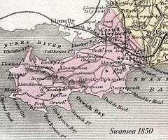 Map of the Gower Peninsula (1850) | |
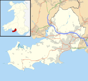 Gower Peninsula Gower Peninsula shown within Swansea | |
| Population | 76,400 |
| OS grid reference | SS465904 |
| Principal area | |
| Ceremonial county | |
| Country | Wales |
| Sovereign state | United Kingdom |
| Police | South Wales |
| Fire | Mid and West Wales |
| Ambulance | Welsh |
| EU Parliament | Wales |
| UK Parliament | |
| Welsh Assembly | |
Gower (Welsh: Gŵyr) or the Gower Peninsula (Penrhyn Gŵyr) is in South Wales. It projects westwards into the Bristol Channel and is the most westerly part of the historic county of Glamorgan. In 1956, Gower became the first area in the United Kingdom to be designated an Area of Outstanding Natural Beauty.
Gower was administered as a Rural District of Glamorgan. In 1974 it was merged with the county borough of Swansea, to form the Swansea district.[1] Since 1996, Gower has been administered as part of the unitary authority of City and County of Swansea council.
The Gower constituency elected only Labour members of Parliament from 1906, the longest run (with Normanton and Makerfield) of any UK constituency. This run ended in 2015 with the Conservatives taking the seat. The constituency covers the peninsula and outer Gower areas including Clydach, Gowerton, Gorseinon, Felindre, Garnswllt, and encompasses the area of the Lordship of Gower, less the city of Swansea.
Geography
About 70 square miles (180 km2) in area, Gower is known for its coastline, popular with walkers and outdoor enthusiasts, especially surfers. Gower has many caves, including Paviland Cave and Minchin Hole Cave. The peninsula is bounded by the Loughor Estuary to the north and Swansea Bay to the east. Gower Area of Outstanding Natural Beauty covers 188 km², including most of the peninsula west of Crofty, Three Crosses, Upper Killay, Blackpill and Bishopston.[2] The highest point of Gower is The Beacon at Rhossili Down at 193 metres (633 ft) overlooking Rhossili Bay.[3] Pwll Du and the Bishopton Valley form a statutory Local Nature Reserve.[4]
The interior of Gower consists mainly of farmland and common land. The population resides mainly in villages and small communities, though suburban development has made a number of communities in eastern Gower part of the Swansea Urban Area.[5]
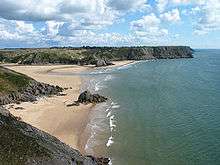
The southern coast consists of a series of small, rocky or sandy bays, such as Langland and Three Cliffs, and larger beaches such as Port Eynon, Rhossili and Oxwich Bay. The north of the peninsula has fewer beaches, and is home to the cockle-beds of Penclawdd.
.jpg)
History
Stone Age
Wales is known to have been inhabited since at least the Upper Paleolithic period, and the Gower Peninsula has been the scene of several important archaeological discoveries. In 1823, archaeologists discovered a fairly complete Upper Paleolithic human male skeleton in Paviland Cave. They named their find the Red Lady of Paviland because the skeleton is dyed in red ochre, though later investigators determined it was actually a male. This was the first human fossil to have been found anywhere in the world, and is still the oldest ceremonial burial anywhere in Western Europe. The most recent re-calibrated radiocarbon dating in 2009 indicates that the skeleton can be dated to around 33,000 Before Present (BP). In 1937 the Parc Cwm long cairn was identified as a Severn-Cotswold type of chambered long barrow. Also known as Parc le Breos burial chamber, it is a partly restored Neolithic chambered tomb. The megalithic burial chamber, or "cromlech", was built around 6,000 BP. In the 1950s, members of Cambridge University excavating in a cave on the peninsula found 300–400 pieces of flint related to toolmaking, and dated it to between 14,000–12,000 BC. In 2010 an instructor from Bristol University, exploring caves in the same area, discovered a rock drawing of a red deer from the same period, which may be the oldest cave art found in Great Britain.[6]
Bronze Age
.jpg)
Gower is also home to menhirs or standing stones from the Bronze Age. Of the nine stones, eight remain today. One of the most notable of the stones is Arthur's stone near Cefn Bryn. Its 25-ton capstone was most likely a glacial erratic (a piece of rock/conglomerate carried by glacial ice some distance from the rock outcrop from which it came): the builders dug under it and supported it with upright stones to create a burial chamber. The remains of Sweyne Howes on Rhossili Down, Penmaen Burrows Tomb (Pen-y-Crug) and Nicholaston Long Cairn are three other well-known Neolithic chambered tombs. During the Bronze Age, people continued to use local caves for shelter and for burying their dead. Bronze Age evidence, such as funeral urns, pottery and human remains, has been found in Tooth Cave at Llethryd, Culver Hole (Port Eynon) and Cat Hole Cave. With the transition into the Iron Age, hill forts (timber fortifications on hill tops and coastal promontories) and earthworks began to appear. The largest example of this type of Iron Age settlement in the Gower Peninsula is Cilifor Top near Llanrhidian.
Roman era
Roman occupation brought new settlement. The Romans built Leucarum, a rectangular or trapezoidal fort at the mouth of the River Loughor, in the late 1st century AD to house a regiment of Roman auxiliary troops. Its remains are located beneath the town of Loughor. Stone defences were added to the earthen ditch and rampart by AD 110 and the fort was occupied until the middle or end of that century. However, it was later abandoned for a time and in the early 3rd century the ditch naturally silted up. It appears to have been brought back into use during the reign of Carausius who was worried about Irish raids, but was abandoned again before the 4th century. A Norman castle was later built on the site.
Anglo-Normans
Following the Norman invasion of Wales the commote of Gŵyr passed into the hands of English-speaking barons, and its southern part soon became Anglicised. In 1203 King John (1199–1216) granted the Lordship of Gower to William III de Braose (d. 1211) for the service of one knight's fee.[7] It remained with the Braose family until the death of William de Braose, 2nd Baron Braose in 1326, when it passed from the family to the husband of one of his two daughters and co-heiresses, Aline and Joan. In 1215 a local lord, Rhys Gryg of Deheubarth, claimed control of the peninsula, but in 1220 he ceded control to the Anglo-Norman lords, perhaps on the orders of his overlord, Llywelyn ap Iorwerth.
Tudor era
In 1535 the Act of Union made the Lordship of Gower part of the historic county of Glamorgan, and its south-western section became the hundred of Swansea.
Economy
Agriculture remains important to the area, but tourism plays an increasing role in the local economy. The peninsula has a Championship status golf course at Fairwood Park just off Fairwood Common, which twice hosted the Welsh PGA Championships in the 1990s. Meanwhile, the Gower Golf Club at Three Crosses hosts the West Wales Open, a two-day tournament on Wales' professional golf tour, the Dragon Tour. Gower is part of the Swansea Travel to Work Area[8] (see Economy of Swansea).
Landmarks
There are numerous cairns and standing stones. A large standing stone called Carreg Bica (also known as Maen Bredwan, Maen Bradwen and Meynhirion) is located on a hill which overlooks Skewen, Neath.
There are six castles on the Gower Peninsula: Bovehill Castle (also known as Landimore Castle), Oystermouth Castle, Oxwich Castle, Pennard Castle, Penrice Castle and Weobley Castle.
Four beaches have Blue Flag beach and Seaside (2006) awards for their high standards: Bracelet Bay, Caswell Bay, Langland Bay and Port Eynon Bay.[9][10] Five other beaches have been given the Green Coast Award 2005 for "natural, unspoiled environment": Rhossili Bay, Mewslade Bay, Tor Bay, Pwll Du Bay, and Limeslade Bay.[11]
Other beaches include:
Llethryd Tooth Cave
The Llethryd Tooth Cave, or Tooth Hole cave, is a Bronze Age ossuary site in a limestone cave, about 1,500 yards (1.4 km) north north west of the Parc Cwm long cairn cromlech, on private land along the Parc Cwm valley, near the village of Llethryd. In 1961 the cave was rediscovered by cavers, who found human bones. An excavation was carried out by D.P. Webley & J. Harvey in 1962 revealing the disarticulated remains (i.e. not complete skeletons) of six adults and two children, dated to the Early Bronze Age or Beaker culture. Other finds are now held at the National Museum of Wales, Cardiff: Early Bronze Age, or Beaker, collared urn pottery; flaked knives; a scraper; flint flakes; a bone spatula; a needle & bead; and animal bones – the remains of domesticated animals, cat and dog. Archaeologists Alasdair Whittle and Michael Wysocki note that this period of occupation may be "significant", with respect to Parc Cwm long cairn, as it is "broadly contemporary with the secondary use of the tomb". In their article published in The Proceedings of the Prehistoric Society (vol.64 (1998), pp. 139–82) Whittle and Wysocki suggest corpses may have been placed in caves near the cromlech until they decomposed, when the bones were moved to the tomb – a process known as excarnation.[12][13][14][15][16]
At 1,525 m long (nearly 1 mile), the Tooth Cave is the longest cave in Gower. It has tight and flooded sections, and so is kept locked for safety.[17][18]
Representation in the media
The village of Mumbles set the scene for a six-part drama Ennals Point featuring Welsh actor Philip Madoc. The series focused on the local lifeboat crew and first aired in January 1982.
Susan Howatch's 1984 novel The Wheel of Fortune is primarily set in the area surrounding the Gower Peninsula, which plays an important part in the plot of the novel.
A film, Gower Boy, made by artist Gee Vaucher and musician Huw Warren, described as a "gentle, contemplative exploration of the Gower Peninsula in Wales", debuted at the 14th Raindance Film Festival in October 2006 .
The village of Rhossili appeared as a location in the 2006 Doctor Who episode "New Earth", in which Worm's Head could also be seen.[19]
See also
Further reading
- Prehistoric Gower, The Early Archaeology of West Glamorgan, by J. G. Rutter, 1949 (published by Welsh Guides, York Street, Swansea)
- Gower, by Olive Phillips, 1956 (published by Robert Hale Limited, London)
- Gower Journey, by A. G. Thompson, c1960 (self published by the author, Principality Chambers, Swansea)
- Portrait of Gower, by Wynford Vaughan Thomas, 1976 (published by Robert Hale Limited, London)( ISBN 0709155778)
- The Gower Coast: A Coastline Walk And Guide To The History, Legends, Shipwrecks & Rescues, Smuggling, Castles & Caves, Including The Story Of The Dollar Ship, by George Edmunds, 1979 ( ISBN 0906570018)
- The Gower Peninsula, by Lawrence Rich (for The National Trust) ( ISBN 9781843592754)
- The Story of Gower, by Wendy Hughes, 1996 ( ISBN 0863812171)
- Historic Gower, by Paul Davies, 1997 ( ISBN 0715407325)
- Images of Wales: Gower Peninsula, by David Gwynn, 2002 ( ISBN 075242615X)
- The People of Gower, by Derek Draisey, 2003 ( ISBN 0954654404)
- Gower Rogues, by Derek Draisey, 2006 ( ISBN 0954654439)
- Gower, by Jonathan Mullard (in The New Naturalist Library, Collins)( ISBN 0007160666)
- Gower in History: Myth, People, Landscape, by Paul Ferris, 2009 ( ISBN 9780956233202)
- Gower, by Nigel Jenkins & David Pearl, 2009 ( ISBN 9781848510524)
References
- ↑ "Archives Network Wales". Archived from the original on 2009-06-30. Retrieved 2008-02-27.
- ↑ The City and County of Swansea Archived 2009-03-26 at the Wayback Machine.
- ↑ Enjoy Gower – Gower Beaches
- ↑ "Pwll Du and Bishopton Local Nature Reserve". Green Map. Retrieved 8 December 2010.
- ↑ Gower (2008). In Encyclopædia Britannica. Retrieved July 22, 2008, from Encyclopædia Britannica Online
- ↑ "Carving found in Gower cave could be oldest rock art". BBC News. 25 July 2011. Retrieved 28 July 2011.
- ↑ Sanders, I.J., Feudal Military Service in England, Oxford, 1956, p.12, note 1; Charter transcribed in Clarke, G.T., Cartae, vol.3, pp.234–5
- ↑ National Statistics Online
- ↑ Keep Wales Tidy – Tourism – Blue Flags Archived 2006-11-02 at the Wayback Machine.
- ↑ Keep Wales Tidy – Tourism – Seaside Award Beaches 2006 Archived 2007-09-14 at the Wayback Machine.
- ↑ Keep Wales Tidy – Tourism – Green Coast Award Beaches 2005 Archived 2007-10-06 at the Wayback Machine.
- ↑ "Key Sites Southeast Wales – Neolithic and earlier Bronze Age" (PDF). Research Framework for the Archaeology of Wales website. Research Framework for the Archaeology of Wales. 2003-12-22. Retrieved 2008-11-04.
- ↑ "Tooth Cave-Site Details-Coflein". The Royal Commission on the Ancient and Historical Monuments of Wales website. Royal Commission on the Ancient and Historical Monuments of Wales. 11 July 2002. Retrieved 4 November 2008.
- ↑ "Bibliography of Cave Sites Literature". Chamberlain, A.T. & Williams, J.P. 2000 A Gazetteer of Welsh Caves, Fissures and Rock Shelters Containing Human Remains. Department of Archaeology and Prehistory, University of Sheffield. 5 December 2000. Archived from the original on 9 June 2010. Retrieved 4 November 2008.
- ↑ "Bibliography of Cave Sites Literature". Chamberlain, A.T. & Williams, J.P. 2000 A Gazetteer of Welsh Caves, Fissures and Rock Shelters Containing Human Remains. Department of Archaeology and Prehistory, University of Sheffield. 5 December 2000. Archived from the original on 4 May 2006. Retrieved 4 November 2008.
- ↑ Whittle, Alasdair; Wysocki, Michael (1998). "Parc le Breos Cwm Transepted Long Cairn, Gower, West Glamorgan: Date, Contents, and Context". Proceedings of the Prehistoric Society. London: The Prehistoric Society. 64: 177. doi:10.1017/s0079497x00002206. ISSN 0079-497X.
- ↑ "Tooth Cave". UK Caves database website. UK Caves database. 2008. Retrieved 4 November 2008.
- ↑ "content > – Gower Caves". Explore Gower website. Stella Elphick. 2008. Retrieved 4 November 2008.
- ↑ "The Welsh Connection: 5 Factoids about the Doctor and Wales". BBC. March 1, 2015. Retrieved March 1, 2015.
External links
| Wikivoyage has a travel guide for Gower Peninsula. |
- Gower Hidden History blog
- Gower Wildlife blog
- Gower Peninsula at Curlie (based on DMOZ)
- BBC Gower website
- The official website of The Gower Society