Gold Star Memorial Bridge
| Gold Star Memorial Bridge | |
|---|---|
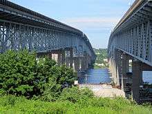 A view of the two spans of The Gold Star Memorial Bridge, as seen from the pedestrian path on the Groton side, looking back toward New London across the Thames River. | |
| Coordinates | 41°21′51″N 72°05′15″W / 41.3642°N 72.0875°WCoordinates: 41°21′51″N 72°05′15″W / 41.3642°N 72.0875°W |
| Carries |
Motor vehicles and a pedestrian/bicycle path on the south span |
| Crosses | Thames River |
| Locale | New London, Connecticut |
| Official name | Gold Star Memorial Bridge |
| Maintained by | Connecticut Department of Transportation |
| Characteristics | |
| Design | Truss - Deck |
| Total length | 1,807.8 m (5,931 ft 1 1⁄4 in) / 1,941 m (6,368 ft 1 3⁄8 in) |
| Width |
24.4 m (80 ft 5⁄8 in) / 24.4 m (80 ft 5⁄8 in) |
| Clearance below | 41.1 m (134 ft 10 1⁄8 in) |
| History | |
| Opened | 1943 (twinned 1973) |
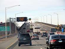
The Gold Star Memorial Bridge is a pair of steel truss bridges that carry both Interstate 95 and U.S. Route 1 across the Thames River between New London, Connecticut, US and Groton, Connecticut. The bridge is the largest structure in the state with more than 1,000,000 sq ft (93,000 m2) of deck area, and the longest bridge in the state at 6,000 feet (1,829 m).[1] Its 11 highway lanes accommodate an average daily traffic of 117,000 vehicles.[2] The bridge is actually a set of twin bridges, but they are generally spoken of using the singular "bridge;" the local media and residents refer to it as "The Goldstar".
History
The bridge was completed in 1943 as a single span. It was part of Southeastern Connecticut's "free span" highway bypass, a short 3.6-mile (5.8 km) long four-lane stretch connecting New London to Groton, Connecticut. As part of the new highway, the bridge's purpose was to remove automobiles from a previous bridge that carried U.S. Route 1 over the Thames River.[3] In 1958, the bypass was connected to the intersection of routes 95 and 395 in East Lyme.[4]
The 13-mile (21 km) Route 184 bypass was completed to the Rhode Island border on December 12, 1964, officially making the bridge and both bypasses part of Interstate 95.[4] In 1951, the bridge was designated as the Gold Star Memorial Bridge in honor of members of the Armed Forces from Groton, New London, and Waterford who lost their lives during World War I, World War II, and the Korean War.[5]
During construction of the second span on July 1, 1972, the US Coast Guard Academy's three-masted barque USCGC Eagle (WIX-327) was involved in a serious accident with the bridge as she was returning to her berth in New London. The ship's foremast and mainmast caught the safety netting slung below the new bridge, despite extensive precautions, as she passed below the original span and the new span being built parallel to it. Both masts were snapped off about seven-eighths of the way up, the upper parts left hanging dangerously from the remaining upright masts. The ship had to undergo emergency repairs as a result.
The bridge's second span was completed in 1973.[6]
Design
The design is a pair of steel truss bridges, each composed of eleven spans.[7][8]
The posted traffic speed limit is 55 miles per hour.
The bridge's southbound span has a sidewalk/bike path accessible from Bridge St and Riverview Ave on the Groton side and Williams Street on the New London side.[9][10]
Gallery
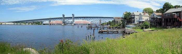 Panorama from the south, showing the northbound span and Amtrak bridge
Notes
- ↑ "WTS CT Valley Chapter: 2009 Annual Awards Program" (PDF). Women's Transportation Seminar. 8 April 2010. Archived from the original (PDF) on 5 October 2011. Retrieved 14 August 2011.
- ↑ "2006 Traffic Volumes State Maintained Highway Network (Traffic Log)" (PDF). Connecticut Department of Transportation. 2006. Retrieved 14 August 2011.
- ↑ Oglesby, Scott (30 November 2009). "Connecticut US 1". Kurimi. Retrieved 14 August 2011.
- 1 2 "Connecticut Turnpike". nycroads.com. Retrieved 14 August 2011.
- ↑ "2005 Connecticut Code - Sec. 13a-31. Gold Star Memorial Bridge named". Justia. 2005. Retrieved 14 August 2011.
- ↑ New London Day, July 1, 1972.
- ↑ "Gold Star Memorial Bridge". Bridgehunter. 19 March 2011. Retrieved 14 August 2011.
- ↑ "Gold Star Memorial Bridge". Structurae. 28 February 2007. Retrieved 14 August 2011.
- ↑ "BIKE NEW LONDON BIKE ROUTES, TRAILS, AND MAPS". Bike New London. Retrieved 14 August 2011.
- ↑ "2009 Connecticut Bicycle Map" (PDF). Connecticut Department of Transportation. Retrieved 14 August 2011.
External links
| Wikimedia Commons has media related to Gold Star Memorial Bridge. |