Gleirschbach
| Gleirschbach | |
|---|---|
 | |
| Country | Austria |
| Physical characteristics | |
| Main source | Tyrol |
| River mouth |
Isar 47°22′33″N 11°18′30″E / 47.3759°N 11.3084°ECoordinates: 47°22′33″N 11°18′30″E / 47.3759°N 11.3084°E |
| Length | ~ 12 km (7.5 mi) |
| Basin features | |
| Progression | Isar→ Danube→ Black Sea |
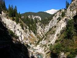
The Gleirschbach originates north of the "Pfeishütte" in the "Samer Valley" on 1.200m sea-level. The creek has a length of app. 12 km; 7.40 km are on the city area of Innsbruck. At the "Möslalm" the Gleirschbach picks up the 1.40 km long Angerbach, which originates on the northern side of the Nordkette.
At the exit of the "Hinterau Valley" the Gleirschbach merges with the Isar. The water possesses A grade quality and is popular with rafting - fans.
This article is issued from
Wikipedia.
The text is licensed under Creative Commons - Attribution - Sharealike.
Additional terms may apply for the media files.