Gitwinksihlkw
| Gitwinksihlkw Canyon City | |
|---|---|
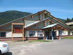 Gitwinksihlkw Elementary School | |
 Gitwinksihlkw Location of Gitwinksihlkw in British Columbia | |
| Coordinates: 55°11′30″N 129°13′00″W / 55.19167°N 129.21667°WCoordinates: 55°11′30″N 129°13′00″W / 55.19167°N 129.21667°W | |
| Country |
|
| Province |
|
| Indigenous territories |
|
| Government | |
| • Governing body | Nisga'a Lisims Government |
| Population | |
| • Total | 201 |
| Time zone | UTC−8 (PST) |
| • Summer (DST) | UTC−7 (PDT) |
| Postal code | V0J 3T0 |
| Area code(s) | 250 |
Gitwinksihlkw (/ˈɡɪtwɪnsɪlk/ GIT-win-silk,[1] /-wɪŋkʃɪsk/ -wink-shisk)[2] formerly Canyon City, is a Nisga'a Village in the Nass River valley of northwestern British Columbia, Canada, near that river's confluence with the Tseax River. An older spelling is Kitwilluchsilt. It is one of four Nisga'a villages. Road access is via the Nisga'a Highway.
Gitwinksihlkw means "people of the lizard's habitat", a reference to the presence of ksilkw (salamanders) in the area prior to the eruption of Tseax Cone in the 18th century which buried the neighbouring villages of Wii Lax K'abit and Lax Ksiluux.
Education
The community is served by School District 92 Nisga'a and hosts Gitwinksihlkw Elementary School. The secondary school is in Gitlakdamix.
See also
References
- ↑ "Name Details: Gitwinksihlkw". BC Geographical Names Search. GeoBC. Retrieved 6 January 2014.
- ↑ "Pronunciation Guide to First Nations in British Columbia". Aboriginal Affairs and Northern Development Canada. Archived from the original on 23 January 2014. Retrieved 7 January 2014.
External links
- Nisga'a Lisims - village website
- School website
- Nisga'a Nation Knowledge Network
- City-Data information
This article is issued from
Wikipedia.
The text is licensed under Creative Commons - Attribution - Sharealike.
Additional terms may apply for the media files.