Georgia State Route 83
| ||||
|---|---|---|---|---|
 | ||||
| Route information | ||||
| Maintained by GDOT | ||||
| Length | 86.5 mi[1] (139.2 km) | |||
| Major junctions | ||||
| South end |
| |||
|
| ||||
| North end |
| |||
| Location | ||||
| Counties | Monroe, Jasper, Morgan, Walton | |||
| Highway system | ||||
| ||||

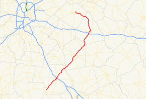
State Route 83 (SR 83) is an 86.5-mile-long (139.2 km) state highway that runs southwest to northeast, with a southeast–to–northwest section, within portions of Monroe, Jasper, Morgan, and Walton counties in the central part of the U.S. state of Georgia. It connects Forsyth, Monticello, and Madison. The portion from the southwestern city limits of Monticello to the Jasper–Morgan county line is included in the Monticello Crossroads Scenic Byway.
Route description
SR 83 begins at an intersection with US 341/SR 7 (Peach Blossom Trail) northeast of Culloden, in Monroe County. It heads northeast, briefly paralleling the Monroe–Lamar county line, to Forsyth. Once in Forsyth, the route forms a concurrency with US 41/SR 18, heading to downtown. Once in downtown Forsyth, the route intersects US 41/SR 18/SR 42. Here, SR 42/SR 83 begin a brief concurrency to the north. Less than 2,000 feet (0.61 km) later, the concurrency ends. SR 83 has an interchange with Interstate 75 (I-75) before leaving Forsyth. Just before leaving Monroe County, the route crosses over the Towaliga River and intersects US 23/SR 87 near Juliette. The route continues to the northeast, crossing over the Ocmulgee River at the Monroe–Jasper county line, and heads toward Monticello. Just prior to entering town, it has an intersection with SR 380 (Perimeter Road), a bypass south and east of the town. SR 83 then makes its way into downtown, where it intersects SR 11/SR 16/SR 212 at the southwestern corner of the town's square. The four routes are concurrent for one block (the southeastern corner of the square), where SR 11's southern lanes depart the concurrency. However, since the square is a one-way road, SR 11's northern lanes continue the concurrency to the northeastern corner of the square. Here, SR 16's and SR 212's eastbound lanes depart the concurrency and SR 83 departs the square and the concurrency. SR 83 then leaves Monticello, passing the Hunter Pope Country Club, and continues to travel to the northeast, toward Madison. On the way, the route has an intersection with SR 142 in Shady Dale. Shortly after, it crosses into Morgan County. Then, it crosses over the Little River. In Madison, it has an interchange with I-20. Then, it begins a concurrency with US 278/SR 12. Just under 4,000 feet (1,200 m) later, US 129/US 441/SR 24 join the concurrency on the northeastern corner of Walton Park. The six routes head to the northeast, past Hill Park, before reaching downtown. Once in downtown Madison, SR 83 leaves the concurrency and travels to the northwest, toward Monroe. It passes through the town of Bostwick. It crosses into Walton County and enters Good Hope, where the route has an intersection with the western terminus of SR 186. SR 83 continues in a northwest direction until its northern terminus, an intersection with US 78/SR 10 in the northeastern part of Monroe.[1]
SR 83 is not part of the National Highway System, a system of roadways important to the nation's economy, defense, and mobility.[2]
Major intersections
| County | Location | mi[1] | km | Destinations | Notes |
|---|---|---|---|---|---|
| Monroe | | 0.0 | 0.0 | Southern terminus | |
| Forsyth | 12.1 | 19.5 | Southern end of US 41/SR 18 concurrency | ||
| 12.5 | 20.1 | Northern end of US 41/SR 18 concurrency; southern end of SR 42 concurrency | |||
| 12.9 | 20.8 | Northern end of SR 42 concurrency | |||
| 13.1 | 21.1 | I-75 exit 187 | |||
| | 23.6 | 38.0 | |||
| Ocmulgee River | 24.6 | 39.6 | Monroe–Jasper county line | ||
| Jasper | | 37.2 | 59.9 | Western terminus of SR 380 | |
| Monticello | 38.3 | 61.6 | Southern end of SR 11/SR 16/SR 212 concurrency, at the southwestern edge of town square, on one-way street | ||
| 38.4 | 61.8 | Northern end of SR 11 concurrency, at the southeastern edge of town square, on one-way street | |||
| 38.4 | 61.8 | Northern end of SR 11 concurrency, at the northeastern edge of town square, on one-way street | |||
| Shady Dale | 47.2 | 76.0 | |||
| Morgan | | 54.5 | 87.7 | Little River | |
| Madison | 60.9 | 98.0 | I-20 exit 113 | ||
| 62.5 | 100.6 | Southern end of US 278/SR 12 concurrency | |||
| 63.3 | 101.9 | Southern end of US 129/US 441/SR 24 concurrency | |||
| 64.1 | 103.2 | Northern end of US 129/US 278/US 441/SR 12/SR 24 concurrency | |||
| Walton | Good Hope | 81.5 | 131.2 | Western terminus of SR 186 | |
| Monroe | 86.5 | 139.2 | Northern terminus | ||
1.000 mi = 1.609 km; 1.000 km = 0.621 mi
| |||||
Monticello connector route
| |
|---|---|
| Location | Bypass around Monticello |
| Length | 5.8 mi[3] (9.3 km) |
| Existed | 1983[4][5]–1985[5][6] |
State Route 83 Connector (SR 83 Connector) was a 5.8-mile-long (9.3 km) connector that existed entirely within the central part of Jasper County. It is the original number of SR 380.
It started at an intersection with the SR 83 mainline (Forsyth Street) southwest of Monticello. Immediately, the route crossed over a Norfolk Southern Railway line and traveled to the southeast. The route curved to the south-southeast and back to the southeast. It passed north of Malone Lake before it curved to the east and intersected SR 11 south of the town. Then, SR 83 Connector traveled to the northeast to an intersection with SR 212 (Milledgeville–Monticello Road) east-southeast of Monticello. Just past this intersection, SR 83 Connector met its eastern terminus, an intersection with SR 16 east of town.[4][5]
The entire route is in Jasper County.
| Location | mi[1] | km | Destinations | Notes | |
|---|---|---|---|---|---|
| | 0.0 | 0.0 | Western terminus | ||
| | 2.4 | 3.9 | |||
| | 4.9 | 7.9 | |||
| | 5.8 | 9.3 | Eastern terminus | ||
| 1.000 mi = 1.609 km; 1.000 km = 0.621 mi | |||||
See also
.svg.png)

References
- 1 2 3 4 Google (July 22, 2013). "Route of SR 83" (Map). Google Maps. Google. Retrieved July 22, 2013.
- ↑ "National Highway System: Georgia" (PDF). United States Department of Transportation. October 1, 2012. Retrieved June 22, 2013.
- ↑ Google (September 15, 2013). "Route of SR 83 Connector" (Map). Google Maps. Google. Retrieved September 15, 2013.
- 1 2 Georgia State Highway System (PDF) (Map). Cartography by GSHD. Georgia State Highway Department. January 1, 1983. Archived from the original (PDF) on October 29, 2013. Retrieved September 15, 2013.
- 1 2 3 Georgia State Highway System (PDF) (Map). Cartography by GSHD. Georgia State Highway Department. January 1, 1984. Archived from the original (PDF) on October 29, 2013. Retrieved September 15, 2013.
- ↑ Georgia State Highway System (PDF) (Map). Cartography by GSHD. Georgia State Highway Department. January 1, 1986. Archived from the original (PDF) on October 29, 2013. Retrieved September 15, 2013.
External links
Route map:

- Georgia Roads (Routes 81 - 100)