George's Dock
| George's Dock | |
|---|---|
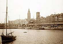 An 1897 postcard of the dock, looking towards Church of Our Lady and Saint Nicholas, Liverpool | |
| Location | |
| Location | Liverpool, United Kingdom |
| Coordinates | 53°24′18″N 2°59′43″W / 53.4050°N 2.9954°WCoordinates: 53°24′18″N 2°59′43″W / 53.4050°N 2.9954°W |
| OS grid | SJ338903 |
| Details | |
| Opened | 1771[1] |
| Closed | 1899 |
| Type | Wet dock |
| Area | 5 acres (2.0 ha), 2,593 sq yd (2,168 m2)[2] |
| Width at entrance | 41 ft 11 in (12.78 m)[3] |
| Quay length | 1,001 yd (915 m)[3] |
George's Dock was a dock, on the River Mersey, England, within the Port of Liverpool. It was connected to Canning Dock to the south and George's Basin to the north.
History
Construction of the dock began in 1762, and was known as North Dock prior to completion.[1] The dock, which opened in 1771, was designed and built by Henry Berry and named after the reigning monarch, King George III.[1] The dock basin originally covered an area of slightly more than 3 acres (1.2 ha).[1] The Goree Warehouses were built to the east of the dock in 1793, and severely damaged during a fire in 1802 which caused over £320,000 of damage.[1] The dock was rebuilt and expanded between 1822-5, after losing its American and Caribbean shipping to Prince's Dock,[1] being expanded by John Foster, Sr.. Following the rebuild and expansion, the dock was mainly used by schooners carrying perishable goods.[1]
The adjoining George's Basin was filled in 1874.[1] In 1899-1900 the dock was filled in to create what is now the Pier Head,[1][4] to provide one central place for Liverpool Docks' offices, which before were scattered across different sites. A section of the original George's Dock wall is still visible in the basement of the Cunard Building which stands on the site.[5] The Goree Warehouses, which had been named after a slave market in West Africa, were destroyed by bombing during World War II.[6]
By March 2009, work was completed[7][8] on a £22 million extension of the Leeds and Liverpool Canal on the site of the former basin. The canal extension provides a further 1.4 miles of navigable waterway.[9]
References
- 1 2 3 4 5 6 7 8 9 McCarron & Jarvis 1992, pp. 39-41
- ↑ Baines 1859, Part II, p. 96
- 1 2 Baines 1859, Part II, p. 116
- ↑ "Trading Places: A History of Liverpool Docks". Liverpool Museums. Archived from the original on 30 September 2009. Retrieved 16 September 2008.
- ↑ "Cunard Building: History". CB Richard Ellis. Archived from the original on 7 October 2011. Retrieved 8 July 2009.
- ↑ "Old Photographs & Drawings of Liverpool". chesterwalls.info. Retrieved 8 September 2016.
- ↑ "Liverpool Canal Link, March 2009 (Page 2: Pier Head)". Pennine Waterways. Archived from the original on 27 November 2010. Retrieved 8 July 2009.
- ↑ "New canal link to boost tourism". BBC News. 25 March 2009. Retrieved 8 July 2009.
- ↑ "Liverpool Canal Link: The Scheme". British Waterways. Archived from the original on 28 July 2009. Retrieved 8 July 2009.
Sources
External links
- "Liverpool North Docks diagram". Archived from the original on 6 January 2009.
- Site of Georges's Dock aerial photo