Geological maps of Senegal
Geological map of Senegal at 1/500 000 (March 2009)
The revision of these three geological maps of Senegal mainly focuses on the sedimentary substratum from Upper Cretaceous to Miocene, the Cap-Vert volcanism from Miocene until Pleistocene, and the superficial Pliocene and Quaternary formations, thus updating these three sheets of the Geological Map of Senegal and Gambia carried out by the Bureau de Recherches géologiques et minières (BRGM) in 1962.
This revision also provided the opportunity to move from the classical chronostratigraphy used back in the 1960s to the lithostratigraphy that is currently more prevalent. Unit names and specific localities are suggested for the new dispensation. The use of satellite imagery and Global Positioning System (GPS) has provided an unprecedented precision.
Data recovered from oil and water exploratory boreholes has produced an in depth knowledge of the subsurface and a new understanding of the tectonics, resulting in the discovery of previously unknown faults.
The mineral resources in the area covered by the three maps are predominantly phosphates, limestone and palygorskite. However, the potential for clay, dolomite, heavy minerals and building gravel merits also to be considered.
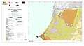 North-West quadrant
 North-East quadrant
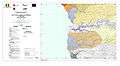 South-East quadrant
Geological map of Senegal at 1/200 000 (March 2009)
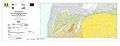
The revision of six geological maps along the Senegal River mainly focuses on the sedimentary substratum from Lower Eocene up to Miocene and the superficial Pliocene and Quaternary formations, thus updating the Senegalese side of four sheets of the Geological Map of Senegal at 1/200 000 and two sheets of the Geological Map of Mauritania carried out by the BRGM in 1967.
Moving from the chronostratigraphy to the prevalent lithostratigraphy renders the terms of Continental terminal and Formation jaune obsolete and it is suggested to replace them with the designations Saloum Formation and Kaedi Member respectively.
Identification of aeolian sands was completed with an attempt to age their deposition. Careful attention was applied to the recognition of fluvial deposits while distinguishing between the meander sands from the clay and the potentially cultivable silt of the settling basins.
The mineral resources of the Matam area include proven reserves of high-grade phosphate as well as possible reserves of arenaceous dolomite. These two resources, coupled with availability of fresh river water, now protected from the tides by the Diama Dam, should improve the potential for agricultural development in the valley.
 Saint-Louis - Dagana
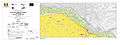 Podor - Saldé
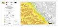 Matam - Semmé
Availability
These maps and explanatory notices are available at the Direction des Mines et de la Géologie (DMG), Centre de Documentation et du Cadastre minier, Boulevard de la République 72, Dakar, Senegal (Telephone/ Fax: +221 338 220 408).
A Multilayered Mapping of the Cap-Vert (2009) also presents geological maps at the scales of 1/50 000 of the activity area of the Cap-Vert to the west of the 16°40’W meridian and of 1/20 000 for the Cap-Vert peninsula to the west of the 17°10’W meridian.
References
- for the explanatory notices:
- ROGER J., NOËL B.J., BARUSSEAU J.P., SERRANO O., NEHLIG P., DUVAIL C. (2009a) – Notice explicative de la carte géologique du Sénégal à 1/500 000, feuilles nord-ouest, nord-est et sud-ouest. Ministère des Mines, de l’Industrie et des PME, Direction des Mines et de la Géologie, Dakar, 61 pages.
- BARUSSEAU J.P., ROGER J., NOËL B.J., SERRANO O., DUVAIL C. (2009) – Notice explicative de la carte géologique du Sénégal à 1/200 000, feuilles de Saint-Louis - Dagana, Podor - Saldé, Matam – Semmé. Ministère des Mines, de l’Industrie et des PME, Direction des Mines et de la Géologie, Dakar, 55 pages.
- for the geological maps at 1/500 000 :
- ROGER J., DUVAIL C., BARUSSEAU J.P., NOËL B.J., NEHLIG P., SERRANO O. (2009b) – Carte géologique du Sénégal à 1/500 000, feuilles nord-ouest, nord-est et sud-ouest. Ministère des Mines, de l’Industrie et des PME, Direction des Mines et de la Géologie, Dakar, 3 coupures.
- for the geological maps at 1/200 000 :
- DUVAIL C., ROGER J., BARUSSEAU J.P., NOËL B.J., SERRANO O. (2009) – Carte géologique du Sénégal à 1/200 000, feuilles de Saint-Louis – Dagana et de Podor - Saldé. Ministère des Mines, de l’Industrie et des PME, Direction des Mines et de la Géologie, Dakar, 2 coupures couvrant chacune 2 feuilles topographiques.
- ROGER J., DUVAIL C., BARUSSEAU J.P., NOËL B.J., SERRANO O. (2009c) – Carte géologique du Sénégal à 1/200 000, feuille de Matam – Semmé. Ministère des Mines, de l’Industrie et des PME, Direction des Mines et de la Géologie, Dakar, 1 coupure couvrant 2 feuilles topographiques.