Geisingberg
| Geisingberg | |
|---|---|
 | |
| Highest point | |
| Elevation | 824 m (2,703 ft) |
| Prominence | 110 m → Brautstock |
| Isolation | 1.8 km → Raubennest |
| Coordinates | 50°46′19″N 13°46′24″E / 50.77194°N 13.773444°ECoordinates: 50°46′19″N 13°46′24″E / 50.77194°N 13.773444°E |
| Geography | |
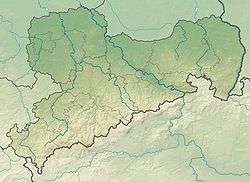
| Parent range | Ore Mountains |
| Geology | |
| Mountain type | cone |
| Type of rock | basalt |
| Climbing | |
| Access | Tower inaugurated in 1891 |
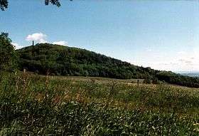
The Geisingberg is a striking basalt mountain in the eastern Ore Mountains in the German federal state of Saxony.
Location and surrounding area
The Geisingberg lies in the upper Eastern Ore Mountains between the mining town of Altenberg and the village of Geising. On its northern and western slopes runs the track of the Müglitz Valley Railway. With a maximum incline here of 1:27 (37 per mil) it is one of the steepest working railway lines in Germany.
Walking routes to the summit
- The easiest ascent runs from Altenberg along the road to the summit.
- Other walks being in Geising and Bärenstein.
- The Eisenach–Budapest international mountain path runs over the Geisingberg.
See also
- List of mountains in the Ore Mountains
- The Gaising (Latvian: Gaiziņkalns), the highest point in Latvia.
References
External links
| Wikimedia Commons has media related to Geisingberg. |
- Information about the Geisingberg Nature Reserve
- Homepage of the Bergbaude Geisingberg (with information about its history and geology)
This article is issued from
Wikipedia.
The text is licensed under Creative Commons - Attribution - Sharealike.
Additional terms may apply for the media files.