Gèdre
| Gèdre | ||
|---|---|---|
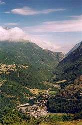 The village of Gèdre and the valley of the Gave de Gavarnie | ||
| ||
 Gèdre Location within Occitanie region  Gèdre | ||
| Coordinates: 42°47′14″N 0°01′12″E / 42.7872°N 0.02°ECoordinates: 42°47′14″N 0°01′12″E / 42.7872°N 0.02°E | ||
| Country | France | |
| Region | Occitanie | |
| Department | Hautes-Pyrénées | |
| Arrondissement | Argelès-Gazost | |
| Canton | La Vallée des Gaves | |
| Area1 | 14.46 km2 (5.58 sq mi) | |
| Population (1999)2 | 292 | |
| • Density | 20/km2 (52/sq mi) | |
| Time zone | UTC+1 (CET) | |
| • Summer (DST) | UTC+2 (CEST) | |
| INSEE/Postal code | 65192 /65120 | |
| Elevation |
905–3,194 m (2,969–10,479 ft) (avg. 1,000 m or 3,300 ft) | |
|
1 French Land Register data, which excludes lakes, ponds, glaciers > 1 km2 (0.386 sq mi or 247 acres) and river estuaries. 2 Population without double counting: residents of multiple communes (e.g., students and military personnel) only counted once. | ||
.svg.png)
Gèdre is a former commune in the Hautes-Pyrénées department in south-western France. On 1 January 2016, it was merged into the new commune of Gavarnie-Gèdre.[1]
See also
References
- ↑ Arrêté préfectoral 18 December 2015
| Wikimedia Commons has media related to Gèdre. |
This article is issued from
Wikipedia.
The text is licensed under Creative Commons - Attribution - Sharealike.
Additional terms may apply for the media files.