Gatter Mountains
| Gatter Mountains | |
|---|---|
| Gattergebirge | |
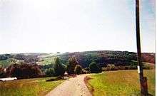
 View from Sankt Wolfgang hamlet of Burdberg looking northwest | |
| Highest point | |
| Peak | Unnamed kuppe near the Sankt Wolfgang hamlet of Schedenberg |
| Elevation | 618 m above NHN |
| Coordinates | 48°14′01″N 12°12′23″E / 48.23361°N 12.20639°ECoordinates: 48°14′01″N 12°12′23″E / 48.23361°N 12.20639°E |
| Geography | |
 Gatter Mountains | |
| State | Counties of Erding and Mühldorf am Inn; Bavaria (Germany) |
| Parent range | Isar-Inn Gravel Beds |
The Gatter Mountains (German: Gattergebirge) are a large, hill range up to about 618 m above sea level (NHN)[1] and just under 50 km² in area[1] in the province of Upper Bavaria in Germany. They lie near the town of Sankt Wolfgang in the counties of Erding and Mühldorf am Inn.
The German names, Gattergebirge and Gatterberg(e) are often seen colloquially as interchangeable. With height differences of no more than around 160 metres, the landscape does not really appear mountainous, but more like a prominent range of hills made from terminal moraines. They are known in Sankt Wolfgang as "the Tuscany of Upper Bavaria".
Southeastern foothills of the Gatter Mountains near Oberornau
References
- 1 2 Gattergebirge am Bereich seines höchsten Gipfels, auf geoportal.bayern.de
This article is issued from
Wikipedia.
The text is licensed under Creative Commons - Attribution - Sharealike.
Additional terms may apply for the media files.