GSI3D
GSI3D (Geological Surveying and Investigation in 3 dimensions) is a methodology and associated software tool for 3D geologic modeling developed by Hans-Georg Sobisch (INSIGHT Geologische Softwaresysteme, Germany) over the last 20 years initially in collaboration with the Geological Survey of Lower Saxony (LBEG) and the Oldenburg-Ostfriesland Waterboard (OOWV) in Germany and from 2006-2010 in collaboration with the British Geological Survey. GSI3D has been further developed and is now solely available as INSIGHT's SubsurfaceViewer MX. The software is written in Java and data is stored in extensible mark-up language XML.
A brief outline of the methodology
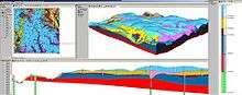
GSI3D utilises a digital elevation model, surface geological linework and downhole borehole and geophysical data to enable the geologist to construct cross sections by correlating boreholes and the outcrops to produce a geological fence diagram. Mathematical interpolation between the nodes along the drawn sections and the limits of the units produces a solid model comprising a stack of triangulated objects each corresponding to one of the geological units present. Scientists draw their sections based on facts such as borehole logs correlated by intuition - the shape 'looks right' to a geologist. This 'looks right' element pulls on the geologists' wealth of understanding of earth processes, examination of exposures and theoretical knowledge gathered over a career in geology. GSI3D enables the efficient capture of tacit and implicit knowledge which was until now trapped in geologist's heads.
GSI3D Research Consortium
Between April 2010 and April 2015, The British Geological Survey operated the 5-year GSI3D Research Consortium under license from INSIGHT GmbH. This not-for-profit consortium provided subscription-based access to a BGS-customized version of GSI3D along with a website and support package as a platform to develop a geological modelling community based around the cross-section methodology. The consortium successfully brought together Geological Surveys, commercial companies and academics from around the globe.
The British Geological Survey is continuing to use GSI3D to develop an increased understanding of the subsurface, please see our webpage http://www.bgs.ac.uk/services/3Dgeology/
GSI3D is now solely available as part of INSIGHT GmbH's SubsurfaceViewer MX platform http://www.subsurfaceviewer.com.
Further reading
- Mathers, S.J.; Terrington, R.L.; Waters, C.N.; Leslie, A.G. (2014). "GB3D – a framework for the bedrock geology of Great Britain". Geoscience Data Journal. 1: 30–42. doi:10.1002/gdj3.9.
- Lark, R.M.; Mathers, S.J.; Thorpe, S.; Arkley, S.,L.,B.; Morgan, D.J.; & D.J.D. Lawrence. 2013. A statistical assessment of the uncertainty in a 3-D geological framework model. Proceedings of the Geologists' Association. Volume 124, issue 6, year 2013, pp. 946 – 958.
- Tame, C.; Cundy, A.B.; Royse, K.R.; Smith, M.; Moles, N.R. (2013). "Three-dimensional geological modelling of anthropogenic deposits at small urban sites: A case study from Sheepcote Valley, Brighton, UK". Journal of Environmental Management. 129: 628–634. doi:10.1016/j.jenvman.2013.08.030.
- Aldiss, D.T. (2013). "Under-representation of faults on geological maps of the London region: reasons, consequences and solutions". Proceedings of the Geologists' Association. 124: 929–945. doi:10.1016/j.pgeola.2013.03.001.
- Aldiss, D.T. & R. Haslam. 2013. Discovery of previously unrecognised local faults in London, UK, using detailed 3D geological modelling. Geophysical Research Abstracts, Vol. 15, EGU General Assembly 2013. http://meetingorganizer.copernicus.org/EGU2013/EGU2013-10625.pdf
- Lark, M.; Mathers, S.; Thorpe, S.; Arkley, S.; Morgan, D.; & D.J.D Lawrence. 2013. Empirical assessment of the uncertainty in a 3-D geological framework model. [Poster] In: EGU General Assembly 2013, Vienna, Austria, 7–12 April 2013. European Geosciences Union. http://nora.nerc.ac.uk/500681/1/posterb.pdf
- Leslie, G.; Cooper, M.; McConnell, B. (2013). "Solid achievement". Geoscientist. 23 (3).
- Kikuchi, C, P. 2013. Shallow groundwater in the Matanuska-Susitna Valley, Alaska — Conceptualization and simulation of flow. USGS Scientific Investigations Report: 2013-5049. https://pubs.er.usgs.gov/publication/sir20135049
- British Geological Survey. 2013. Going underground – 3D bedrock geology map goes national. EuroGeoSurveys News, Issue 9, January 2013. http://www.eurogeosurveys.org/assets/files/newsletters/2013/egs_newsletter_2013_09.pdf%5Bpermanent+dead+link%5D
- Callaghan, E.; Kearsey, T.; Finlayson, A. & C. Auton. 2012. Model metadata report for the GSI3D model of shallow geophysical surveys for the ground seaward of the Drigg Low Level Waste Repository Site, West Cumbria. British Geological Survey, 13pp. (IR/12/071) http://nora.nerc.ac.uk/500002/1/IR12071.pdf
- Ó Dochartaigh, B.É. 2012. Groundwater-surface water interaction in an upland hillslopefloodplain environment, Eddleston, Scotland. BHS Eleventh National Symposium, Hydrology for a changing world, Dundee 2012. doi: 10.7558/bhs.2012.ns42; http://www.hydrology.org.uk/assets/2012%20papers/ODochartaigh_42.pdf%5Bpermanent+dead+link%5D
- Keefer, D. & J. Thomason, 2012. Tricks, Tools, and Techniques for 3-D Geologic Mapping. USGS Digital Mapping Techniques workshop 2012. http://ngmdb.usgs.gov/Info/dmt/docs/DMT12_Keefer.pdf
- Finlayson, A (2012). "Glacial landsystems from below – insights from three-dimensional geological modelling". Quaternary International. 279-280: 144. doi:10.1016/j.quaint.2012.08.110.
- Kessler, H.; Dearden, R., Mathers, S. & D. Peach. 2012. 3D Geological Mapping - uncovering the subsurface to increase environmental understanding. [Poster] AGU Fall meeting San Francisco. http://nora.nerc.ac.uk/20972/ http://fallmeeting.agu.org/2012/files/2012/12/AGU-poster_final_conference.pdf
- Burke, H. F., Morgan, D. J R., Kessler. H. K. E. Cooper, A. H., 2012. Using 3D Models to Better Understand the Eeffects of Superficial Deposits on Aquifer Recharge. GSA 2012 Conference Abstract: https://gsa.confex.com/gsa/2012AM/webprogram/Paper207182.html
- Aldiss, D.T.; Black, M.G.; Entwisle, D.C.; Page, D.P.; Terrington, R.L. (2012). "Benefits of a 3D geological model for major tunnelling works : an example from Farringdon, east-central London, UK". Quarterly Journal of Engineering Geology and Hydrogeology. 45 (4): 405–414. doi:10.1144/qjegh2011-066.
- Auton, Clive; Everest, Jeremy. 2012 The BGS Talla Earth Observatory Site. [Other] In: Glaciation of the Scottish Borders, Glacial Landsystems Working Group Field Meeting, Tweedsmuir Hills in the Scottish Borders, 26–28 October 2012. 19-22. (Unpublished) http://nora.nerc.ac.uk/20147/
- Auton, Clive; Arkley, Sarah; Leslie, Alick. 2012 Moray Firth 3D onshore-offshore modelling. [Poster] In: 2nd GSI3D Research Consortium Workshop, BGS Keyworth, 17–18 October 2012. (Unpublished) http://nora.nerc.ac.uk/20069/
- Millward, D.; Stephenson, D.. 2011 Bedrock GS13D models from interpreted data in geologically complex Carboniferous terrains : a work in progress from the Clyde catchment area, Midland Valley of Scotland. Nottingham, UK, British Geological Survey, 58pp. (IR/11/052) (Unpublished) http://nora.nerc.ac.uk/19394/
- Peterson, G. 2012. Sedimentologisk studie och tredimensionell modell av endrumlin öster om Billingen SGU-rapport 2012:15. (in Swedish, abstract in English) https://web.archive.org/web/20130618220119/http://www.sgu.se/dokument/service_sgu_publ/SGU-rapport_2012-15.pdf
- Asch, K.; Mathers, S.J. & H. Kessler. 2012. Geology. In: Kresse, W. & Danko, D. M. (Editors), Springer Handbook of Geographic Information, 1100 p. 688 figs., 116 tabs. pp. 857–884.
- Finlayson, A (2012). "Ice dynamics and sediment movement: last glacial cycle, Clyde basin, Scotland". Journal of Glaciology. 58: 209. doi:10.3189/2012JoG11J207.
- Nonogaki, S (2011). "Current Trends and Issues in Three-Dimensional Geologic Modeling System Based on Geologic Boundary Surfaces". Geoinformatics. 22 (3): 131–142. doi:10.6010/geoinformatics.22.131.
- Michael, S.; Baumberger, R. & Oesterling, N. 2011. Geological 3D modelling of Quaternary sequences using GSI3D – an example of the surroundings of Berne. Presentation at 9th Swiss Geoscience Meeting, Zurich 2011. http://geoscience-meeting.scnatweb.ch/sgm2011/PPT_Session_15_SGM2011/10_Michael_etal.pdf
- de Beer, J.; Price, S. J.; Ford, J.R. (2011). "3D modelling of geological and anthropogenic deposits at the World Heritage Site of Bryggen in Bergen, Norway". Quaternary International. 251: 107–116. doi:10.1016/j.quaint.2011.06.015.
- Berg, R.C.; Mathers, S.J.; Kessler, H. & D. A. Keeefer (eds.). 2011. Synopsis of Current Three-dimensional Geological Mapping and Modeling in Geological Survey Organizations. Illinois State Geological Survey Circular 578. https://web.archive.org/web/20111009122101/http://library.isgs.uiuc.edu/Pubs/pdfs/circulars/c578.pdf
- Ward, E., Cullen, H. & L. Hughes. 2011. 3D Geological Models for Teaching. GGES conference: Geoscience Graduates for the 21st Century, Leeds, 19 January 2011 (presentation). https://web.archive.org/web/20110817025027/http://gees.ac.uk/events/2011/earthsci11/documents/Ward3DGeologicalModelsforTeachingGEES2011.ppt
- Nelson, C. E.; Jerram, D. A.; Hobbs, Terrington; Kessler, H. (2011). "Reconstructing flood basalt lava flows in three dimensions using terrestrial laser scanning". Geosphere. 7: 87–96. doi:10.1130/GES00582.1.
- Tye, A.M.; Kessler, H.; Ambrose, K.; Williams, J.D.O.; Scheib, A.; Raines, M.; Kuras, O. (2011). "Using integrated near-surface geophysical surveys to aid the mapping and interpretation of geology in a Trent landscape within a 3D geological framework". Near Surface Geophysics. 9 (1): 15–31. doi:10.3997/1873-0604.2010038.
- Finlayson, A.; Merritt, J.; Browne, M.; Merritt, J.; McMillan, A. (2010). "Ice sheet advance, dynamics, and decay configurations: evidence from west central Scotland". Quaternary Science Reviews. 29 (7–8): 969–988. doi:10.1016/j.quascirev.2009.12.016.
- Mathers, S.J., & H. Kessler. 2010. GSI3D Version 2.6.3 User manual. Nottingham, UK, British Geological Survey, 120pp. (OR/10/007)
- Ford, J. R., Mathers, S. J., Royse, K. R., Aldiss, D. T. & D. J. R. Morgan. 2010. Geological 3D modelling: scientific discovery and enhanced understanding of the subsurface, with examples from the UK. Zeitschrift der Deutschen Gesellschaft für Geowissenschaften, Volume 161, Number 2, June 2010, pp. 205–218 (14), Stuttgart. http://www.ingentaconnect.com/content/schweiz/zdgg/2010/00000161/00000002/art00009
- Price, S. J., Burke, H. F., Terrington, R. L., Reeves, H., Boon, D & A. Scheib. 2010. The 3D characterisation of the zone of human interaction and the sustainable use of underground space in urban and peri-urban environments: case studies from the UK. Zeitschrift der Deutschen Gesellschaft für Geowissenschaften, Volume 161, Number 2, June 2010, pp. 219–235 (17), Stuttgart. http://www.ingentaconnect.com/content/schweiz/zdgg/2010/00000161/00000002/art00010;jsessionid=56225t47lmptr.alexandra
- Royse, K.R., Kessler, H., Robins, N.S., Hughes, A.G., & S. J. Mathers. 2010. The use of 3D geological models in the development of the conceptual groundwater model. Zeitschrift der Deutschen Gesellschaft für Geowissenschaften, Volume 161, Number 2, June 2010, pp. 237–249 (13), Stuttgart. http://www.ingentaconnect.com/content/schweiz/zdgg/2010/00000161/00000002/art00011
- Campbell, S. D. G., Merritt, J. E., Dochartaigh, B., Mansour, M., Hughes, A. G., Fordyce, F. M., Entwisle, D. C., Monaghan, A. A. & S. Loughlin. 2010. 3D geological models and their hydrogeological applications: supporting urban development - a case study in Glasgow-Clyde, UK. Zeitschrift der Deutschen Gesellschaft für Geowissenschaften, Volume 161, Number 2, June 2010, pp. 251–262(12), Stuttgart. http://www.ingentaconnect.com/content/schweiz/zdgg/2010/00000161/00000002/art00012;jsessionid=56225t47lmptr.alexandra
- Royse, K. R. (2010). "Combining numerical and cognitive 3D modelling approaches in order to determine the structure of the Chalk in the London Basin". Computers and Geosciences. 36 (4): 500–511. doi:10.1016/j.cageo.2009.10.001.
- Mathers, S. & H. Kessler. 2010. International viewpoint and news - Shallow subsurface 3D geological models for environmental and earth science decision making. Environmental Earth Sciences, 60 (2). 4 pp. http://www.springerlink.com/content/m5r01165139262ln/
- Kessler, H. Terrington R., Sobisch, H-G., Gunnink, J., Ludwig, R., Harms, E., Turner, K., & R. Moore. 2010. The need for improved management of the subsurface. [Extended Abstract] First International Conference on Frontiers in Shallow Subsurface Technology, Delft January 2010. http://nora.nerc.ac.uk/9258/
- Ward, E. 2010. 3D Models for Teaching. GEES Geosciences Student Learning event 2010. [conference abstract and poster] Overcoming Barriers to Learning in the Geosciences, January 2010, School of Geography, Earth & Environmental Sciences, University of Birmingham https://web.archive.org/web/20100201063030/http://gees.ac.uk/events/2010/geobarriers10/geobarriers10.htm#ward
- Wang, L., Tye, T., & A. Hughes. 2009. Riverine floodplain groundwater flow modelling – the case of Shelford (UK). British Geological Survey Internal Report (IR/09/043) 28pp. http://nora.nerc.ac.uk/9556/2/IR-09-43.pdf
- Nelson, C. E., Jerram, D. A., & R.W. Hobbs. 2009. Reconstructing flood basalt lava flows using terrestrial laser scanning and GSI3D software. Abstract G51B-0664. American Geophysical Union, Fall Meeting 2009. http://adsabs.harvard.edu/abs/2009AGUFM.G51B0664N
- Farrell, R., Whiteman, M. & H. Kessler. 2009. Geological and Hydrogeological Models in the Environment Agency [Poster]. Portland GSA Annual Meeting October 2009. https://gsa.confex.com/gsa/2009AM/finalprogram/abstract_163777.htm
- Kessler, H., Campbell, D., Ford, J.R., Giles, J.R.A., Hughes, A.G., Jackson, I., Peach, D.W., Price, S.J., Sobisch, H-G., Terrington, R.L., and B. Wood. 2009. Building on geological models: the vision of an environmental modelling platform: In: Three-dimensional geological mapping : workshop extended abstracts : 2009 Annual Meeting : Geological Society of America: Portland, Oregon, Illinois State Geological Survey, p. 24-30. http://nora.nerc.ac.uk/8423/1/BUILDING_ON_GEOLOGICAL_MODELS_final.pdf
- Mathers, S.J., Kessler, H., Wood, B. & H.-G. Sobisch. 2009. The deployment of 3D geological modelling at the British Geological Survey. Conference abstract, Portland GSA Annual Meeting, October 2009. http://gsa.confex.com/gsa/2009AM/finalprogram/abstract_160987.htm
- Ford, J.R., Price, S.J., Cooper, A.H. & H. Kessler. 2009. The enhanced classification of artificial ground as a tool to investigate and represent anthropogenic processes in the recent geological record. [Poster] In: UK Archaeological Sciences Biennial Conference (UKAS), Nottingham, UK, 8-10 Sept 2009. Nottingham, UK, British Geological Survey. http://nora.nerc.ac.uk/8629/
- Royse, K. R.; Rutter; Entwisle, D. C. (2009). "Property attribution of 3D geological models in the Thames Gateway, London: new ways of visualising geoscientific information". Bulletin of Engineering Geology and the Environment. 68 (1): 1–16. doi:10.1007/s10064-008-0171-0.
- Rogers, C.D.F., Chapman, D.N., Entwisle, D., Jones, L., Kessler, H., Metje, N., Mica, L., Morey, M., Pospíšil, P., Price, S., Raclavsky, J., Raines, M., Scott, H.& A.M. Thomas. 2009. Predictive Mapping of Soil Geophysical Properties for GPR Utility Location Surveys. In: Proceedings of the 5th International Workshop on Advanced Ground Penetrating Radar, Granada, Spain, May 27–29, p. 60-67. http://nora.nerc.ac.uk/7898/
- Mathers, S.J., Kessler, H. & H.-G. Sobisch. 2009. 3D Geological Modelling at the British Geological Survey using the GSI3D software and methodology [extended abstract]. In: EUREGEO 2009 : European congress on Regional Geoscientific Cartography and Information Systems, Munich, Germany, 9–12 June 2009. Augsburg, Bayerisches Landesamt fur Umwelt, 82-84. http://nora.nerc.ac.uk/7823/1/Mathers_extended_abstract_5.pdf
- Kessler, H.; Mathers, S.J.; Sobisch, H.-G. (2009). "The capture and dissemination of integrated 3D geospatial knowledge at the British Geological Survey using GSI3D software and methodology" (PDF). Computers & Geosciences. 35: 1311–1321. doi:10.1016/j.cageo.2008.04.005.
- Wycisk, P.; Hubert, T.; Gossel, W.; Neumann, C. (2009). "High-resolution 3D spatial modeling of complex geological structures for an environmental risk assessment of abundant mining and industrial mega sites". Computers & Geosciences. 35: 165–182. doi:10.1016/j.cageo.2007.09.001.
- Scheib, A., Arkley, S., Auton, C., Boon, D., Everest, J., Kuras, O., Pearson, S., Raines, M. & J. Williams. 2009. Multidisciplinary characterisation and modelling of a small upland catchment in Scotland. Questiones Geographicae, Adam Mickiewicz University Press, Poznań (in press). http://nora.nerc.ac.uk/6816/
- Lelliott, M.; Cave, M.; Wealthall, G. (2009). "A structured approach to the measurement of uncertainty in 3D geological models". Quarterly Journal of Engineering Geology and Hydrogeology. 42: 95–105. doi:10.1144/1470-9236/07-081.
- Terrington, R., Napier, B., Howard, A., Ford, J. & W. Hatton. 2008. Why3D?: the need for solution based modeling in a national geoscience organization. In: Oleschko, K., (ed.) GIS in geology and earth sciences. Mexico, American Institute of Physics, 103-112, 9pp. http://nora.nerc.ac.uk/4441/
- Quadrio, B (2008). "The use of single station microtremors for the local seismic hazard assessment: an example in northern Apennine". Scientifica Acta. 2 (2): 39–43.
- Marzorati, S., Fiorini, E., Ameri, G., Onida, M.,and F. Pacor. 2008. Rapporti spettrali hvsr in aree densamente industrializzate: ricostruzione di una superficie pleistocenica profonda al di sotto del polo petrolchimico di priolo gargallo (SR). Gruppo Nazionale di Geofisica della Terra Solida conference 2008. (SR).http://www2.ogs.trieste.it/gngts/gngts/convegniprecedenti/2008/riassunti/2.2/22-marz.pdf
- Asaduzzaman, A.T.M., Ludwig, R.R., Nury, S. N., Kamal, M.A. & N.N. Faruqa. 2008. 3-D Geological Modeling of Pilot Areas in Dhaka City for Urban Hazard Assessment. Presentation at Geoinformatik 2009. Osnabrueck. https://web.archive.org/web/20110719032100/http://www.gi-tage-nord.de/download/2008_04_02_GTN_03_04_Ludwig.pdf
- Fiorini, E., Onida, M., Borzi, B., Pacor, F., Luzi, L., Meletti, C., D’Amico, V., Marzorati, S. & G. Ameri. 2008. Microzonation study for an industrial site in southern Italy. Abstract presented at the 14th World Conference on Earthquake Engineering October 12–17, 2008, Beijing, China. http://www.earth-prints.org/bitstream/2122/4325/1/04-02-0081.pdf
- Williams, J., Scheib, A. 2008. Application of near-surface geophysical data in GSI3D : case studies from Shelford and Talla Linnfoots. British Geological Survey Open File Report(OR/08/068), 29p. http://nora.nerc.ac.uk/5347/1/OR_08_068.pdf
- Boon, D., Kessler, H., Raines, M., Kuras, O., Auton, C., Williams, J., Nice, S., Pearson, S., Weller, A. & S. Arkley. 2008. Modelling Scottish peat stratigraphy using integrated electrical geophysics. [Lecture] In: Reinforced Water : Engineering And Environmental Considerations In Construction Over Peat, Edinburgh, Scotland, 11 March 2008. http://nora.nerc.ac.uk/4830/1/ModellingScottishPeatAbstact_Final.pdf
- Mathers, S. & H. Kessler. 2008. GSI3D the software and methodology to build systematic near-surface 3-D geological models - Version 2.6. British Geological Survey Open File Report, (OR/08/064) 130pp.
- Royse, K., Reeves, H., & A. Gibson. 2008. The modelling and visualisation of digital geoscientific data as an aid to land-use planning in the urban environment, an example from the Thames Gateway. In: Liverman, DGE; Pereira, C; Marker, B, (eds.) Communicating environmental geoscience. London, UK, Geological Society of London, 89-106, 17pp. (Special publication, 305). http://nora.nerc.ac.uk/4822/1/D81C305.pdf
- Turner, A. K., Price, S., Kessler, H., & M. Culshaw. 2008. Creating 3D Geological Subsurface Models for Urban Areas. GSA Houston Annual Meeting. http://gsa.confex.com/gsa/2008AM/finalprogram/abstract_146137.htm
- Royse, K.; Rutter, H.; Entwisle, D. (2008). "Property attribution of 3D geological models in the Thames Gateway, London: new ways of visualising geoscientific information". Bulletin of Engineering Geology and the Environment. 68: 1–16. doi:10.1007/s10064-008-0171-0.
- Ford, J., Burke, H., Royse, K. & S.J. Mathers. 2008. The 3D geology of London and the Thames Gateway : a modern approach to geological surveying and its relevance in the urban environment. In: Cities and their underground environment : 2nd European conference of International Association of engineering geology: Euroengeo 2008, Madrid, Spain, 15-20 Sept 2008. http://nora.nerc.ac.uk/3717/1/FORT3D.pdf
- Kessler, H., Turner, A.K., Culshaw, M. & K. Royse. 2008. Unlocking the potential of digital 3D geological subsurface models for geotechnical engineers. In: Cities and their underground environment : 2nd European conference of International Association of engineering geology: Euroengeo 2008, Madrid, Spain, 15-20 Sept 2008. http://nora.nerc.ac.uk/3817/1/EUROENGEO_2008_Kessler_et_al.pdf
- Price, S., Terrington, R., Ford, J., Crofts, R., Diamond, K. & K. Seymour. 2008. A 3D assessment of urban aquifer vulnerability using geological and buried asset models : a case study from Knowsley Industrial Park, NW England. In: European econference of the International Association for Engineering geology, Madrid, Spain, 15-20 Sept 2008. http://nora.nerc.ac.uk/4997/1/025.pdf
- Smith, B. et al. 2008. 3D Modelling of geology and soils - A case study from the UK. In: A.E. Hartemink et al. (eds.), Digital Soil Mapping with Limited Data, Springer. 436pp. https://web.archive.org/web/20070913002748/http://www.globalsoilmap.net/Riobook.html
- Mathers, S.J., Kessler, H. & H.-G. Sobisch. 2008. The geological maps of the future: 3D modelling at BGS using the GSI3D software and methodology. Presentation at the International Geological Congress, Oslo, 6–14 August 2008. http://www.cprm.gov.br/33IGC/1257345.html
- Mathers, S.J. (editor). 2008. Extended Abstracts of the 2nd International GSI3D Conference, 2–3 September 2008. British Geological Survey Open File Report (OR/08/054), 30pp. http://nora.nerc.ac.uk/4477
- Kessler, H., Mathers, S.J. & H.-G. Sobisch. 2008. GSI3D : The software and methodology to build systematic near-surface 3-D geological models - Version 2. British Geological Survey Open File Report (OR/08/001), 144pp.
- Royse, K. 2008. Unlocking the potential of 3D Geology. In: GeoConnexionUK Magazine, July 2008. http://www.geoconnexion.com/uploads/unlocking-pot_olymv1.pdf
- Wollmann, A. 2008. Geologisches 3D-Rauminformationssystem - Geologische 3D- Raummodellierung in einem Areal der ehemaligen Bergbau- und Industriefolgelandschaft Bitterfeld/Wolfen, VDM Verlag Dr. Müller Aktiengesellschaft & Co. KG, Saarbrücken, ISBN 978-3-639-03441-7, S195.
- Campbell, D., Monaghan, A., Entwisle, D., Merritt, J. & M. Browne. 2008. Geoscience for decision making. In: GeoConnexionUK Magazine, February/March 2008. http://www.geoconnexion.com/uploads/geoscience_ukv6i1.pdf
- Campbell, S.D.G, Browne, M.A.E, Entwisle, D.C., Finlayson, A., Grahem, M., Jones, D.G., Fordyce, F.M., Loughlin, S.C., Merritt, J.E., Monaghan, A.A., Pouliquen, G., O'Dochertaigh, B.E., & K. Whitbread. 2007. Accessible 3-D geoscientific spatial data to INSPIRE Scotland’s planners, developers and regulators. AIG conference Inspiring Scotland 2007. http://www.agi.org.uk/SITE/UPLOAD/DOCUMENT/Event_Presentations/120071115_ScotPapers/DiarmadCampbell.pdf%5Bpermanent+dead+link%5D; http://www.agi.org.uk/SITE/UPLOAD/DOCUMENT/Event_Presentations/120071115_Scot/DiarmadCampbell1.pdf%5Bpermanent+dead+link%5D
- AG Hydro- und Umweltgeologie, Martin-Luther-Universität Halle-Wittenberg. 2007. Raummodelle als Grundlage gekoppelter Modellierung. On-line publication. http://www2.uzu.uni-halle.de/3D_Geology/Raummodelle/Text.pdf
- Kessler, H., Mathers, S., Napier, B., Terrington, R. & Sobisch, H.-G. 2007. The present and future construction and delivery of 3D geological models at the British Geological Survey. GSA Denver Annual Meeting. [Poster]. http://nora.nerc.ac.uk/3756/1/Present_future_3Dmodels_(3).pdf
- Cooper, A., Ford, J., Price, S., Hall, M., Burke, H., & Kessler, H. 2007. The digital approach to understanding the Quaternary evolution of the Vale of York, UK. [Poster] Nottingham, UK, British Geological Survey. http://nora.nerc.ac.uk/4077/1/Vale_of_York_(5).pdf
- Wycisk, P., Gossel, W., Schlesier, D. & Neumann, C. 2007. Integrated 3D modelling of subsurface geology and hydrogeology for urban groundwater management. International Symposium on New Directions in Urban Water Management. https://web.archive.org/web/20100107141355/http://www2.gtz.de/Dokumente/oe44/ecosan/en-modelling-urban-groundwater-managment-2007.pdf
- Scheib A. J., Ambrose K., Boon D. P., Kessler H., Kuras O., Lelliott M., Nice S. E., Palmer R. C., Raines M. G., Smith B. 2007. 3D Digital Soil-Geology Models of the Near Surface Environment; Abstract for Pedometrics Biannual Conference of Commission 1.5 Pedometrics, International Union of Soil Sciences, Germany. p85. https://web.archive.org/web/20090510235727/https://biblio.ugent.be/input?func=downloadFile&fileOId=460189. Poster: http://nora.nerc.ac.uk/4128/1/Soils.pdf
- Kessler, H., Mathers, S., Lelliott, M., Hughes, A. & MacDonald, D. 2007. Rigorous 3D geological models as the basis for groundwater modelling. In: Three-dimensional geologic mapping for groundwater applications, Workshop extended abstracts, Denver, Colorado. http://nora.nerc.ac.uk/4129/1/kessler.pdf https://web.archive.org/web/20110611211756/http://www.isgs.uiuc.edu/research/3DWorkshop/2007/powerp/kessler.ppt
- Smith, B., Campbell, S., Fordyce, F., Kessler, H., Price, S., Entwisle, D. & K. Royse. 2007. Understanding heterogeneity and structure in urban environments: a tool for the assessment of risk and interpretation of geochemical data. British Geological Survey [Poster]http://nora.nerc.ac.uk/849/1/heterogeneity.pdf
- Merritt, J.E., Monaghan, A., Entwisle, D., Hughes, A., Campbell, D. & Browne, M. 2007. 3D attributed models for addressing environmental and engineering geoscience problems in areas of urban regeneration – a case study in Glasgow, UK. In: First Break, Special Topic Environmental and Engineering Geoscience, Volume 25, August 2007. pp 79–84. http://www.firstbreak.org/files/special_3d_aug2007.pdf?HPSESSID=110b2385a454ad1ee6dbdf13a2c6ed5b%5Bpermanent+dead+link%5D на русском языке: http://www.firstbreak.nl/files/special_3D_rusaug2007.pdf?HPSESSID=f17310cfceb26d294ecc2392bda7123c%5Bpermanent+dead+link%5D
- Kessler, H. & S. Mathers. 2007 Digital 3D geological models : the geological maps of the future. Suffolk Natural History, 43. 2-6. http://nora.nerc.ac.uk/7118/, http://www.suffolkbrc.org.uk/public_html/sites/default/files/43/TSNS43B.pdf
- Merritt, J.E. & Whitbread, K. 2007. Combining ARC GIS maps and attributed 3D geological models to provide geoscience solutions in the urban environment: Examples from the City of Glasgow and North-east England. In: Coors, V, Rumor, M, Fendle, E.M, & Zlatanova S (eds). 2007. Urban and Regional Data Management. UDMS Annual (Taylor & Francis Group, London). pp 185–192. https://books.google.com/books?id=BB9JnLCBzecC&pg=PA190&lpg=PA190&dq=gsi3d&source=bl&ots=KUhcSM8-Bm&sig=EI5vcn57aT3fcxRlWYKIWCBR0qg&hl=en&sa=X&oi=book_result&resnum=4&ct=result#PPR6,M1
- Giles, J. 2006. Geological Map Database – A Practitioner’s Guide to Delivering the Information. In: David R. Soller (ed.) Digital Mapping Techniques ‘06 - Workshop Proceedings. USGS Open-File Report 2007-1285. pp 77–84. http://pubs.usgs.gov/of/2007/1285/pdf/Giles.pdf http://ngmdb.usgs.gov/Info/dmt/docs/giles06.pdf (presentation)
- Kessler H. 2006. Tools for building and delivering 3D models - Perspectives by the BGS. Presentation at the GGIPAC Workshop, Geoscience Australia, Canberra. https://web.archive.org/web/20070901131758/http://www.geoscience.gov.au/pdf/G_Holger_Kessler.pdf
- Kessler H. & S.J. Mathers. 2006. The past, present and future of 3D Geology in BGS In: Open University Geological Society Journal, Volume 27(2), 13-15. http://nora.nerc.ac.uk/5193/1/OU_paper_3D-Geology.pdf
- Merritt, J., Entwisle, D. & A. Monaghan. 2006. Integrated geoscience data, maps and 3D models for the City of Glasgow, UK. IAEG 2006 Conference Paper No. 394. https://web.archive.org/web/20110721205304/http://www.iaeg.info/iaeg2006/PAPERS/IAEG_394.PDF
- Royse, K.; Entwisle, D.; Price, S.; Terrington, R.; Venus, J. (2006). "Gateway to Olympic success". Geoscientist. 16 (5): 4–10.
- Bridge, D.M., Seymour, K., Kessler, H., Shepley, M., Price, S. J., Lelliott, M., Banks, V.J. & G. Wildman. 2006. 3-D geoscience models and their application to hydrogeological domains mapping. In: The pursuit of science : building on a foundation of discovery, Philadelphia, USA, 22-25 Oct 2006.
- Neighbor, A., Aubel, J., Classon, F., Hoefer, S., Kunz, A. & Sobisch H.-G. 2006. From the Devonian to the present: Landscape and technogenic relief evolution in an urban environment. IAEG 2006 Conference Paper No. 517. https://web.archive.org/web/20110721205321/http://www.iaeg.info/iaeg2006/PAPERS/IAEG_517.PDF
- Perk, M. 2006. Feld-Kalibrierung geophysikalischer Daten auf kontaminierten Flächen mit Hilfe des GIS-gestützten Visualisierungswerkzeugs GSI3D. Dissertation http://kups.ub.uni-koeln.de/frontdoor.php?source_opus=2124%5Bpermanent+dead+link%5D
- Lelliott, M.R.; Bridge, D.McC; Kessler, H.; Price, S.J.; Seymour, K.J. (2006). "The application of 3D geological modelling to aquifer recharge assessments in an urban environment". Quarterly Journal of Engineering Geology and Hydrogeology. 39: 293–302. doi:10.1144/1470-9236/05-027.
- Neighbor, A.; Classon, F.; Howahr, M. (2006). "Construction and usage of geological near-surface models with GSI3D - applied (hydro-)geological information for land sites and urban areas". Austrian Journal of Earth Sciences. 99: 62–69. Archived from the original on 2008-03-31.
- Neighbor, A. & Howahr, M. 2006. Construction and Usage of geological near-surface models with GSI3D - applied (hydro-)geological information for land sites and urban areas. COG 2006, Salzburg, Austria. http://www.geol-ges.at/cog-2006/kurzfassung-neber-howahr.pdf%5Bpermanent+dead+link%5D
- Classon, F., Brunotte, E., Sobisch, H.-G. & Neighbor, A. 2005. Zur dreidimensionalen Modellierung von anthropogenen Ablagerungen in urbanen Räumen am Beispiel des rechtsrheinischen Köln. Geotechnik 2005/2, 93-100.
- Culshaw, M.G. (2005). "From concept towards reality: developing the attributed 3D geological model of the shallow subsurface". Quarterly Journal of Engineering Geology and Hydrogeology. 38: 231–284. doi:10.1144/1470-9236/04-072.
- Kessler, H. et al. 2005. 3D geoscience models and their delivery to customers. In: Three dimensional geologic mapping for groundwater applications, Workshop extended abstracts, Salt Lake City, Utah, 15 October 2005. Geological Survey of Canada, 2005. p. 39-42. https://web.archive.org/web/20110814025740/http://crystal.isgs.uiuc.edu/research/3DWorkshop/2005/pdf-files/kessler2005.pdf, https://web.archive.org/web/20081203171855/http://www.isgs.uiuc.edu/research/3DWorkshop/2005/pdf-files/kessler_15_10_2005-ppt.pdf
- Riddick, A., Laxton, J., Cave, M., Wood, B., Duffy, T., Bell, P., Evans, C.J., Howard, A., Armstrong, B., Kirby, G., Monaghan, A., Ritchie, C., Jones, D., Napier, B., Jones, N., Millward, D., Clarke, S., Leslie, G., Mathers, S., Royse, K., Kessler, H., Newell, A., Dumpleton, S., Loudon, V. & J. Aspden. 2005. Digital geoscience spatial model project final report. Keyworth, British Geological Survey, 56pp. (BGS Occasional Publication No. 9) http://nora.nerc.ac.uk/2366/1/DGSM_Final.pdf
- Weber, B. & K.G. Hinzen. 2004. Influence of the local geology on amplitude, duration and frequency of the earthquake ground motion in the Lower Rhine Ambayment. Poster presented at the annual meeting of the Arbeitsgruppe Seismologie, Bochum, 27.- 29.9.2004. https://web.archive.org/web/20061001185307/http://www.geosum3d.de/cms/Poster_AGSeismo_2004.pdf
- Kessler, H. & S.J. Mathers. 2004. From geological maps to models – finally capturing the geologists’ vision. Geoscientist, 14/10, pp. 4–6. http://nora.nerc.ac.uk/983/1/Map_to_model_article.pdf
- Kessler, H., Mathers, S.J & H.-G. Sobisch. 2004. GSI3D - The software and methodology to build near-surface 3-D geological models. British Geological Survey (IR/04/029), 96pp.
- Hough, E., Kessler, H., Lelliott, M., Price, S., Reeves, H. & D. Bridge. 2003. Look before you leap. In: Moore, H. M., Fox, H. R. & S. Elliott (editors). Land reclamation: Extending the boundaries. pp. 369–375.
- Bridge, D., Hough, E., Kessler, H., Price, S. & H. Reeves. 2003. Urban Geology: Integrating Surface and Sub-Surface Geoscientific Information for Development Needs. In: NATO Science Series IV: Earth and Environmental Sciences. Stanisław R. Ostaficzuk: The Current Role of Geological Mapping in Geosciences. Proceedings of the NATO Advanced Research Workshop on Innovative Applications of GIS in Geological Cartography Kazimierz Dolny, Poland 24–26 November 2003. http://www.springerlink.com/content/l186w2713238206r
- Ellison, R.A., McMillan, A.A., Lott, G.K., Kessler, H. & R.S. Lawley. 2002. Ground characterisation of the urban environment: a guide to best practice. Urban Geoscience and Geological Hazards Programme. Keyworth, British Geological Survey Research Report (RR/02/2005), 37pp. http://nora.nerc.ac.uk/2365/1/groundchar.pdf
- Sobisch, H.-G. 2000. Ein digitales raeumliches Modell des Quartaers der GK25 Blatt 3508 Nordhorn auf der Basis vernetzter Profilschnitte. Shaker Verlag, Aachen.
- Hinze, C.; Sobisch, H.-G.; Voss, H-H. (1999). "Spatial modelling in Geology and its practical Use". Mathematische Geologie. 4: 51–60.
External links
- Luikonlahti geological model
- GSI3D at the Illinois Geological Survey
- 3D geological model featured on the BBC
- a GSI3D model featured on the BBC website
- A GSI3D model of the City of Halle, Germany
- Hydrogeological GSI3D Models in NW Germany
- GSI3D in use at the BGR
- Dr.Hans-Georg Sobisch, developer and holder of the intellectual property rights for GSI3D