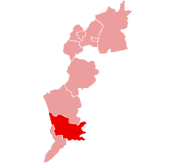
Güssing District
| Bezirk Güssing | |
|---|---|
| District | |
 | |
| Country | Austria |
| State | Burgenland |
| Number of municipalities | 28 |
| Area | |
| • Total | 486.71 km2 (187.92 sq mi) |
| Population (2012) | |
| • Total | 26,636 |
| • Density | 55/km2 (140/sq mi) |
| Time zone | UTC+1 (CET) |
| • Summer (DST) | UTC+2 (CEST) |
| NUTS code | ? |
The Bezirk Güssing (Croatian: Kotar Novi Grad) is an administrative district (Bezirk) in the federal state of Burgenland, Austria, bordering on Vas Megye (County) Hungary, of which it had been a part prior to 1921.
Area of the district is 486.71 km², with a population of 26,636 (2012), and population density 55 persons per km². Administrative center of the district is Güssing.
Administrative divisions
The district consists of the below municipalities and towns, the former Hungarian names of some of which are given in parentheses:
- Bildein (361)
- Bocksdorf (800)
- Burgauberg-Neudauberg (1,375)
- Eberau (1,004)
- Gerersdorf-Sulz (1,044)
- Großmürbisch (262)
- Güssing (3,798)
- Güttenbach (938)
- Hackerberg (363)
- Heiligenbrunn (837)
- Heugraben (222)
- Inzenhof (328)
- Kleinmürbisch (250)
- Kukmirn (2,011)
- Moschendorf (407)
- Neuberg im Burgenland (1,020)
- Neustift bei Güssing (507)
- Olbendorf (1,408)
- Ollersdorf im Burgenland (975)
- Rauchwart (458)
- Rohr im Burgenland (382)
- Sankt Michael im Burgenland (1,018)
- Stegersbach (2,558)
- Stinatz (1,412)
- Strem (928)
- Tobaj (1,393)
- Tschanigraben (72)
- Wörterberg (505)
| Cities | 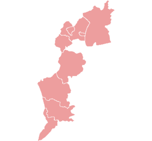 | |
|---|---|---|
| Districts | ||
Coordinates: 47°07′05″N 16°15′40″E / 47.118°N 16.261°E
This article is issued from
Wikipedia.
The text is licensed under Creative Commons - Attribution - Sharealike.
Additional terms may apply for the media files.