Friendship, Suriname
Coordinates: 5°53′8″N 56°19′53″W / 5.88556°N 56.33139°W
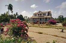
A house in Friendship
Friendship is a town in the Coronie district in Suriname.
It originally was an old plantation, one of the many plantations that lay alongside the East-West Link from Nieuw Nickerie to Paramaribo. From East to West these are:
- Inverness
- Hamilton
- Welgelegen
- Hague
- Bellevue
- Mary's Hope
- Totness
- Friendship
- Corona
- Bantaskine
- Belladrum
- Johanna Maria
- Novar
- Clyde
- Burnside
- Oxford
- Bucklebury
These plantations were built arount 1880 by Scottish and English settlers.
This article is issued from
Wikipedia.
The text is licensed under Creative Commons - Attribution - Sharealike.
Additional terms may apply for the media files.