Hoo Fort
| Hoo Fort | |
|---|---|
| Rochester, Kent, England | |
 A disused fort in the River Medway | |
 Hoo Fort | |
| Coordinates | 51°24′12″N 00°34′53″E / 51.40333°N 0.58139°ECoordinates: 51°24′12″N 00°34′53″E / 51.40333°N 0.58139°E |
| Site information | |
| Owner | Medway Ports |
| Condition | Intact |
| Site history | |
| Built | 19th century |
| Built by | Captain Siborne, R.E.,[1] |
| Materials | Concrete skirts and brickwork |
| Events |
Never used |
| Official name | Hoo Fort |
| Designated | 1 November 1963 |
| Reference no. | 1019643 |
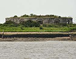
Hoo Fort, like Fort Darnet, was built on the recommendations of the 1859 Royal Commission. It is located on Hoo Island covering Pinup Reach, the inner navigable channel of the River Medway. Hoo Island sits to the south of the Hoo Peninsula and is within the parish of Hoo, Kent. The fort can be viewed from along the Saxon Shore Way, accessible from Vicarage Lane in Hoo.
History
Originally designed for two tiers of guns mounted in a circle, with a boom strung between Hoo Fort and Fort Darnet, there were many problems with subsidence, and after extensive cost overruns the forts were completed in 1871 with a single tier of eleven 9-inch rifled muzzle-loading guns, and no boom.[2] Each gun was mounted in an individual casemate with heavily armoured firing port.[1]
The forts were disarmed before the First World War. In the Second World War, the fort was used as observation posts, with platforms and pillboxes built on top. The fort is still in fair condition. It is a Scheduled Monument[3] and is owned by Medway Ports.[1]
References
- 1 2 3 "Site Name: Hoo Fort". subbrit.org.uk. Retrieved 19 January 2017.
- ↑ "Exploring Kent's past - Hoo Fort". Kent County Council. Retrieved 5 April 2018.
- ↑ "Hoo Fort". Historic England. Retrieved 5 April 2018.
External links
| Wikimedia Commons has media related to Hoo Fort. |