Finsbury Square
.JPG)
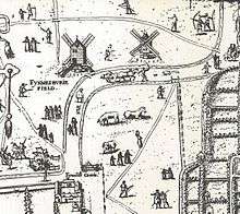
Finsbury Square is a 0.7-hectare (1.7-acre) square in central London which includes a six-rink grass bowling green.[1] It was developed in 1777 on the site of a previous area of green space to the north of the City of London known as Finsbury Fields, in the parish of St Luke's and near Moorfields. It is sited on the east side of City Road, opposite the east side of Bunhill Fields. It is approximately 200m north of Moorgate station, 300m north-west of Liverpool Street station and 400m south of Old Street station. Nearby locations are Finsbury Circus and Finsbury Pavement. Named after it, but several kilometers away, are Finsbury Park and its eponymous neighbourhood.
Finsbury Square is served by bus routes 21, 43, 141, 271, 214 and 274.
History
Past residents of the square include Pascoe Grenfell Hill, Thomas Southwood Smith and Philip Henry Pye-Smith. It has also been the site of the bookshop of James Lackington and the first home of the rabbinical seminary that became the London School of Jewish Studies (1855–81), of the Greek Orthodox church of Saint Sophia and of the Roman Catholic Church of St Mary Moorfields (1820–1900).[2]
From 1907 to 1914,[3] 39 Finsbury Square was the home of the City of London Yeomanry.[4] The site is now occupied by City Gate House which was designed by Frederick Gould and Giles Gilbert Scott and completed in 1930.[5]
In 1784, Vincenzo Lunardi achieved the first successful attempt at hot air balloon flight from Finsbury Square.[6]
The south side of the square was known as Sodomites Walk in the 18th century and was notorious as a gay cruising area.[7]
On 22 October 2011, Occupy London protesters began to camp on the Square.[8] They were subsequently removed in an eviction described by the council as 'peaceful and low key'.[9]
In January 2013, the University of Liverpool announced that its London Campus would be at 33 Finsbury Square.[10]
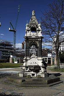
Also in 2013 a memorial was installed at the SW of the square commemorating those who died in the 1975 Moorgate tube crash.[11]
Current developments
10 Finsbury Square is a new 150,000 sq ft office building offering floor plates from 11,400 sq ft to 17,300 sq ft.[12]
Resolution Property is also developing the former Triton Court building at 14 Finsbury Square into Alphabeta - a 220,000 sq ft office block.[13]
The office building at 22-25 Finsbury Square was converted into a five-star hotel with completion in 2016.[14]
Finsbury Square is also the venue for an occasional farmers’ market.[15]
References
| Wikimedia Commons has media related to Finsbury Square, London. |
- ↑ "Finsbury Square". Retrieved 2 April 2014.
- ↑ "History". St Mary Moorfields. Retrieved 3 June 2017.
- ↑ "Regimental History" (PDF). Ministry of Defence. Retrieved 3 June 2017.
- ↑ "Drill Hall Register: A list of the locations of London Drill Halls since 1908" (PDF). Retrieved 14 May 2017.
- ↑ "City Gate House". Brookfield Properties. Retrieved 3 June 2017.
- ↑ "A topographical dictionary of Great Britain and Ireland". John Gorton. 1833. Retrieved 2 April 2014.
- ↑ Homosexualitiy in Eighteenth-Century England: The Sodomites' Walk in Moorfields. Rictornorton.co.uk (2009-08-11). Retrieved on 2013-08-12.
- ↑ "'Occupy London' start camp in Finsbury Square". BBC News. 22 October 2011. Retrieved 22 October 2011.
- ↑ "Occupy London protesters evicted from Finsbury Square". BBC News. 14 June 2012. Retrieved 2 April 2014.
- ↑ Liverpool University in London Prospectus 2013
- ↑ "Moorgate Tube crash memorial unveiled in Finsbury Square". BBC. 28 July 2013. Retrieved 3 June 2017.
- ↑ "KF enlisted for Pembroke's 10 Finsbury Sq". CoStar News. 5 March 2014. Retrieved 2 April 2014.
- ↑ "Take 10 … property pioneers powering the tech sector". Property Week. 20 December 2013. Retrieved 2 April 2014.
- ↑ "Finsbury Square". Retrieved 25 March 2014.
- ↑ "Finsbury Square Farmers Market". Retrieved 2 April 2014.