Feuerspitze
| Feuerspitze | |
|---|---|
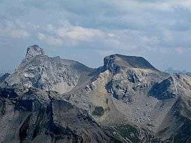 Wetterspitze (left) and Feuerspitze (right), seen from the southwest | |
| Highest point | |
| Elevation | 2,852 m (9,357 ft) |
| Prominence | 120 metres (390 ft) |
| Isolation | 0.68 kilometres (0.42 mi) |
| Coordinates | 47°12′0″N 10°22′0″E / 47.20000°N 10.36667°ECoordinates: 47°12′0″N 10°22′0″E / 47.20000°N 10.36667°E |
| Geography | |
 Feuerspitze Austria | |
| Location | Tyrol, Austria |
| Parent range | Lechtal Alps |
Feuerspitze ("Fire-Peak") is a mountain in the Lechtal Alps of Tyrol. The elevation at its peak is 2,852 metres (9,357 ft). Feuerspitze is located 7 kilometres (4.3 mi) southeast of Holzgau.
This article is issued from
Wikipedia.
The text is licensed under Creative Commons - Attribution - Sharealike.
Additional terms may apply for the media files.