Fóia (mountain)
The summit
With an elevation of 902 metres (2,959 ft) and a topographic prominence of 739 metres (2,425 ft), Fóia is the highest mountain of Algarve, Portugal. It is part of the Serra de Monchique range and is located at 37°18′53″N 8°35′46″W / 37.314795°N 8.596244°WCoordinates: 37°18′53″N 8°35′46″W / 37.314795°N 8.596244°W within Monchique parish.
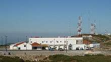
There is a paved road right to the summit which is topped by several telecommunication facilities including the Radar Station N°1 of the Portuguese Air Force. On a clear day the Atlantic Ocean is visible.

| Wikimedia Commons has media related to Serra de Monchique. |
This article is issued from
Wikipedia.
The text is licensed under Creative Commons - Attribution - Sharealike.
Additional terms may apply for the media files.