Extreme points of Slovakia
This is a list of the extreme points of Slovakia: the points that are farther north, south, east or west than any other location, as well as the highest and lowest points.
Latitude and longitude
- North: near Oravská Polhora
- South: Patince
- West: near Záhorská Ves
- East: Nová Sedlica
 Northernmost point of Slovakia
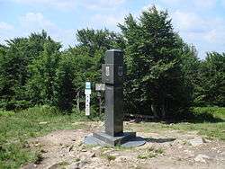 Easternmost point of Slovakia
The distance between Záhorská Ves (the easternmost point) and Nová Sedlica (the westernmost point) is 428 km.
Altitude
- Maximum: Gerlachovsky stit, High Tatras (2655 m)
- Minimum: Streda nad Bodrogom (94 m)
 Highest point of Slovakia
 Lowest point of Slovakia
Other features
- Longest river: Vah (402,5 km).
- Deepest mountain lake: Velke Hincove pleso, High Tatras (53 m deep, 20 hectares)
- Uppermost mountain lake: Modre pleso, High Tatras (2157 m above sea level)
See also
References
This article is issued from
Wikipedia.
The text is licensed under Creative Commons - Attribution - Sharealike.
Additional terms may apply for the media files.