Esch-sur-Sûre
| Esch-sur-Sûre Esch-Sauer | ||
|---|---|---|
| Commune | ||
 Esch-sur-Sûre | ||
| ||
 Map of Luxembourg with Esch-sur-Sûre highlighted in orange, and the canton in dark red | ||
| Coordinates: 49°54′40″N 5°56′05″E / 49.911°N 5.93467°ECoordinates: 49°54′40″N 5°56′05″E / 49.911°N 5.93467°E | ||
| Country |
| |
| Canton | Wiltz | |
| Area rank | ? of 102 | |
| • Rank | ? of 102 | |
| • Density rank | ? of 102 | |
| Time zone | UTC+1 (CET) | |
| • Summer (DST) | UTC+2 (CEST) | |
| LAU 2 | LU0000802 | |
| Website | esch-sur-sure.lu | |

Esch-sur-Sûre (Luxembourgish: Esch-Sauer, pronounced [ˌæʃˈzɑʊ̯ɐ], German: Esch-Sauer [ˌɛʃˈzaʊ̯ɐ]) is a commune and small town in north-western Luxembourg. It is part of the canton of Wiltz, which is part of the district of Diekirch. At one point it was the second smallest commune by area in Luxembourg (after Remich), until Neunhausen and Heiderscheid were merged into it in 2011.[1]
As of 2005, the town of Esch-sur-Sûre, which lies in the north of the commune, has a population of 314.
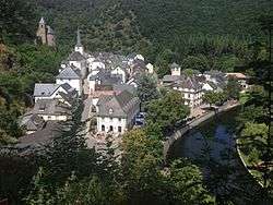
Esch-sur-Sûre is situated by the river Sauer, just east and downstream of the artificial Upper Sauer Lake. The town's prominent castle, and the main part of the town below, sit on a spur of a land within a sharp meander of the river.
The suffix to its name distinguishes Esch-sur-Sûre from the city of Esch-sur-Alzette, which is often known just as Esch.
Immediately above the town, the river has been dammed to form a hydroelectric reservoir extending some 6 miles (10 km) up the valley. The Upper Sauer dam was built in the 1960s to meet the country's drinking water needs.

References
- ↑ "Fusion des communes d'Esch/Sûre, Heiderscheid et Neunhausen". Legilux. Government of Luxembourg. Retrieved 13 June 2015.
External links
| Wikivoyage has a travel guide for Esch-sur-Sûre. |

- www.petitbourg.lu Le Paradis des Ardennes Luxembourgoises
Places adjacent to Esch-sur-Sûre | ||||||||||
|---|---|---|---|---|---|---|---|---|---|---|
| ||||||||||
