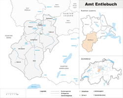
Entlebuch District
| Entlebuch District Wahlkreis Entlebuch | |
|---|---|
| District | |
 | |
| Country |
|
| Canton |
|
| Capital | Schüpfheim |
| Area | |
| • Total | 424.43 km2 (163.87 sq mi) |
| Population (2017) | |
| • Total | 23,508 |
| • Density | 55/km2 (140/sq mi) |
| Time zone | UTC+1 (CET) |
| • Summer (DST) | UTC+2 (CEST) |
| Municipalities | 9 |
Entlebuch District is one of six disctricts (German: Wahlkreise) of the canton of Lucerne, Switzerland. Its administrative center is the village of Schüpfheim.
From 1803 to 2013, it was known as Amt Entlebuch, one of five districts (Ämter) of the canton. It corresponds to the basin of the river Kleine Emme, which had been a territory of canton of Lucerne since 1385 (de jure from 1405).
History
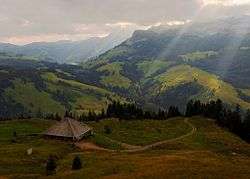
Entlebuch District roughly corresponds to the basin of the Kleine Emme. It is eponymous of the village of Entlebuch, which is in turn named for the rivers Grosse and Kleine Entle, a right tributary of Kleine Emme.
Its area of 395 km² is roughly equivalent to that of the historical Vogtei (bailiwick) of Entlebuch, first mentioned in the 12th century. The bailiwick was owned by the lords of Wolhusen in the 13th century, and passed to the House of Habsburg shortly before 1300. In the 1370s, Entlebuch was in conflict with Obwalden over the right to alpine pastures, culminating in the Battle of Sörenberg in 1380. As a result of the conflict, the Entlebuch sought an alliance with Lucerne and in 1385 became a subject territory of that city (certified de jure after the Battle of Sempach, in 1405). Territorial conflicts with Berne were resolved with a treaty in 1470.
Historically characterised by dispersed settlement, villages formed around churches beginning in the 16th century. There were repeated revolts or riots of the population against the rule of Lucerne during the 15th to 17th century, most notably the Amstaldenhandel (1478), Zwiebelnkrieg (1513) and the finally the Swiss Peasant War of 1653
The modern Amt (district) Entlebuch was established in 1803, with Werthenstein incorporated only in 1889.
The bailiwick had 2,260 inhabitants in 1453, and 5,377 in 1715. Population grew significantly in the later 18th century due to industrialisation, recorded at 12,182 as of 1795. At the height of industrialisation, population was close to 17,000 in 1850.
The region was long known as the "poorhouse of Switzerland" (also as the "Wild West of Lucerne") and is struggling for economic independence even today.
In 2001 UNESCO accepted the region of Entlebuch to become part of the World Network of Biosphere Reserves, in which conservation of the natural and cultural landscape is coupled with strengthening the local economy.
Municipalities
Entlebuch consists of the following municipalities:
| Municipality | Population (31 December 2017)[1] |
Area, km² |
|---|---|---|
| Doppleschwand | 786 | 6.95 |
| Entlebuch | 3,315 | 56.90 |
| Escholzmatt-Marbach | 4,358 | 106.4 |
| Flühli | 1,956 | 108.24 |
| Hasle | 1,752 | 40.33 |
| Romoos | 670 | 37.24 |
| Schüpfheim | 4,181 | 38.37 |
| Werthenstein | 2,115 | 15.80 |
| Wolhusen | 4,375 | 14.3 |
| Total | 23,508 | 424.43[2] |
Mergers and name changes
- On 1 January 2013 the former municipalities of Escholzmatt and Marbach merged to form the new municipality of Escholzmatt-Marbach. The municipality of Wolhusen moved from the Sursee District to the Entlebuch District.[3][4]
See also
References
- ↑ Swiss Federal Statistical Office - STAT-TAB, online database – Ständige und nichtständige Wohnbevölkerung nach institutionellen Gliederungen, Geburtsort und Staatsangehörigkeit (in German) accessed 17 September 2018
- ↑ LUSTAT-Canton of Lucerne Statistical Office as of 2000 survey, (in German) accessed 25 August 2009
- ↑ Nomenklaturen – Amtliches Gemeindeverzeichnis der Schweiz (in German) accessed 9 February 2013
- ↑ Amtliches Gemeindeverzeichnis der Schweiz published by the Swiss Federal Statistical Office (in German) accessed 2 January 2013
External links
- District of Entlebuch in German, French and Italian in the online Historical Dictionary of Switzerland.
- Entlebuch online (in German)
- UNESCO Biosphaere Entlebuch