Ellsworth Mountains
| Ellsworth Mountains | |
|---|---|
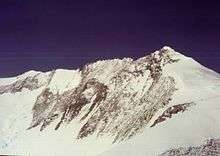
 The central part of Ellsworth Mountains with Mount Tyree, Mount Shinn and Mount Vinson; Nimitz Glacier in the foreground | |
| Highest point | |
| Peak | Mount Vinson |
| Elevation | 4,892 m (16,050 ft) |
| Coordinates | 78°31′31.74″S 85°37′01.73″W / 78.5254833°S 85.6171472°W |
| Dimensions | |
| Length | 360 km (220 mi) NNW-SSE |
| Width | 48 km (30 mi) WE |
| Geography | |
 Location of Ellsworth Mountains in Antarctica | |
| Continent | Antarctica |
| State/Province | Ellsworth Land |
| Range coordinates | 78°45′S 85°00′W / 78.750°S 85.000°WCoordinates: 78°45′S 85°00′W / 78.750°S 85.000°W |
The Ellsworth Mountains are the highest mountain ranges in Antarctica, forming a 360 km (224 mi) long and 48 km (30 mi) wide chain of mountains in a north to south configuration on the western margin of the Ronne Ice Shelf in Marie Byrd Land.[1] They are bisected by Minnesota Glacier to form the Sentinel Range to the north and the Heritage Range to the south. The former is by far the higher and more spectacular with Mount Vinson (4,892 m) constituting the highest point on the continent. Geologically, they are part of the Antarctandes which stretch from the Antarctic Peninsula to Cape Adare on the western shore of the Ross Sea. The Antarctandes form the southernmost arc of the Pacific 'Ring of Fire'. The mountains are located within the Chilean Antarctic territorial claim but outside of the Argentinian and British ones.
Discovery
The mountains were discovered on November 23, 1935, by Lincoln Ellsworth in the course of a trans-Antarctic flight from Dundee Island to the Ross Ice Shelf. He gave the descriptive name Sentinel Range.[1]
The mountains were mapped in detail by the U.S. Geological Survey from ground surveys and U.S. Navy aerial photography, 1958-66. When it became evident that the mountains comprise two distinct ranges, the US-ACAN restricted the application of Sentinel Range to the high northern one and gave the name Heritage Range to the southern one; the Committee recommended the name of the discoverer for this entire group of mountains.[1]
Climate
The temperatures in the Ellsworth Mountains average around -30 °C (-20 °F). The best time for expeditions are November through January, mid-summer in the Southern Hemisphere. However, arranging an outing here is a difficult task, requiring either official scientific sponsorship or considerable financial resources.
Maps
- Newcomer Glacier. Scale 1:250 000 topographic map. Reston, Virginia: US Geological Survey, 1961.
- Vinson Massif. Scale 1:250 000 topographic map. Reston, Virginia: US Geological Survey, 1988.
- Union Glacier. Scale 1:250 000 topographic map. Reston, Virginia: US Geological Survey, 1966.
- Liberty Hills. Scale 1:250 000 topographic map. Reston, Virginia: US Geological Survey, 1966.
- Antarctic Digital Database (ADD). Scale 1:250000 topographic map of Antarctica. Scientific Committee on Antarctic Research (SCAR). Since 1993, regularly updated.
See also
Gallery
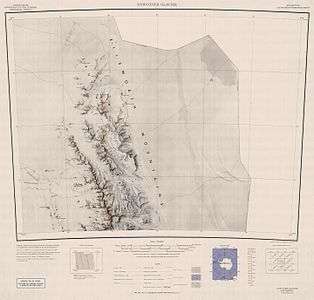 Northern Sentinel Range, USGS map
 Central and southern Sentinel Range, USGS map
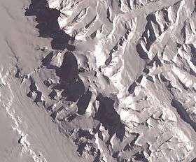 The central part of the mountains with Vinson Plateau, NASA satellite image
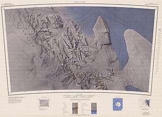 Northern Heritage Range, USGS map
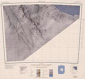 Southern Heritage Range, USGS map
.jpg)
.jpg)
_from_East_by_Christian_Stangl_(flickr).jpg)
.jpg)
References
- 1 2 3 "Ellsworth Mountains". Geographic Names Information System. United States Geological Survey. Retrieved 2004-05-06.
External links
| Wikimedia Commons has media related to Ellsworth Mountains. |
- Scientific Committee on Antarctic Research (SCAR)
- Ellsworth Mountains. SCAR Composite Gazetteer of Antarctica
| General |
| .svg.png) |
|---|---|---|
| Geographic regions | ||
| Waterways | ||
| Famous explorers | ||