El Yunque (Puerto Rico)
- This article refers to the mountain. For information on the national forest, see El Yunque National Forest.
| Pico El Yunque | |
|---|---|
 El Yunque peak | |
| Highest point | |
| Elevation | 1,080 m (3,540 ft) |
| Coordinates | 18°18′38″N 65°47′29″W / 18.31056°N 65.79139°WCoordinates: 18°18′38″N 65°47′29″W / 18.31056°N 65.79139°W |
| Geography | |
 Pico El Yunque | |
| Parent range | Sierra de Luquillo |
| Climbing | |
| Easiest route | Hike |
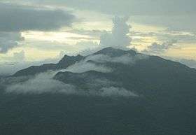
Pico El Yunque or El Yunque Peak is a mountain that is located fully within the boundaries of the El Yunque National Forest, part of the U.S. Forest Service, which is the only tropical rainforest that belongs to the U.S. Forest Service. The peak itself is one of the highest in Puerto Rico, standing at 1,080 meters (3543 feet) above sea level. The peak is nearly always covered in thin mist and, due to its high humidity, a quick shower develops during some afternoons.

Its name is Spanish for "The Anvil".
Neighboring Peaks
- Cerro de Punta (1,338 m 4,390 ft)
- Toro Negro (1,074 m 3533 ft)
- Pico Del Oeste (1,056m (3,446 ft)
- El Cacique (1,020m 3,346 ft)
- Mount Briton (937m 3,075 ft)
- La Mina de Pantalones (931m 3,055 ft)
Climate

El Yunque is classified as having a tropical monsoon climate, which is rare and tends to see less variance in temperatures during the course of the year than a tropical savanna climate. The Köppen Climate Classification subtype for this climate is "Am" (Tropical Monsoon Climate).[1] The area receives over 100 inches of rainfall every year.[2]
See also
References
- ↑ Climate Summary for closest location on record
- ↑ "Naguabo, Puerto Rico". weatherbase.com. Retrieved 25 January 2015.
| Wikimedia Commons has media related to El Yunque (Puerto Rico). |