East Thrace
Coordinates: 41°9′13″N 27°22′0″E / 41.15361°N 27.36667°E

East Thrace, or Eastern Thrace (Turkish: Doğu Trakya or simply Trakya; Greek: Ανατολική Θράκη, Anatoliki Thraki; Bulgarian: Източна Тракия, Iztochna Trakiya), also known as Turkish Thrace or European Turkey, is the part of the modern Republic of Turkey that is geographically part of Southeast Europe. It accounts for 3% of Turkey's land area but comprises 14% of Turkey's total population.[1] The rest of the country is located on the Anatolian peninsula, geographically in Western Asia. East Thrace is of historic importance as it is next to a major sea-based trade corridor. It is currently also of specific geostrategic importance because the sea corridor, that includes two narrow straits, provides access to the Mediterranean from the Black Sea for the navies of five countries: Russia, Ukraine, Romania, Bulgaria, and Georgia. The region also serves as a future connector of existing Turkish and European high speed rail networks.
Definition
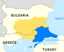
East Thrace includes all in the eastern part of the historical region of Thrace. The area includes all the territories of the Turkish provinces of Edirne, Tekirdağ and Kırklareli, as well as those territories on the European Continent of the provinces of Çanakkale and Istanbul.
Climate
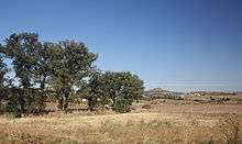
Due to the moderating effect of the surrounding seas, the climate tends to be Mediterranean in character. It can descend down to about 12°C and can rise to about 32°C, similar to Asian Turkey.
Geography
East Thrace has an area of 23,764 km2 (3 percent of the country), slightly smaller than Sardinia, and a population of about 11 million people or about 14 percent of the total population (in 2015); the population density is around 430 people/km2, compared to about 80 people/km2 for Asiatic Turkey, which is also called Anatolia or Asia Minor. However, densities are skewed by the metropolis of Istanbul. The two continents are separated by the Dardanelles, the Bosphorus (collectively known as the Turkish Straits) and the Sea of Marmara, a route of about 361 km. The southernmost part of Eastern Thrace is called the Gallipoli peninsula. European Turkey is bordered on the west by Greece for 212 km and on the north by Bulgaria for 269 km, with the Aegean Sea to the south-west and the Black Sea to the north-east.[2][3]
| Province (part) | Area (km2) |
Population (2012 census)[4] |
Density (pop/km2) (2012 census) |
Population (2015 est.) |
|---|---|---|---|---|
| Istanbul Province (European) | 3,421 | 8,963,431 | 2620.1 | 9,492,000** |
| Tekirdağ | 6,218 | 852,321 | 137.1 | 937,910** |
| Kırklareli | 6,550 | 341,218 | 52.1 | 346,973 |
| Edirne | 6,279 | 399,708 | 63.7 | 402,537 |
| Çanakkale (European) | 1,296 | 64,061 | 49.4 | 62,000 |
| East Thrace (sum) | 23,764 | 10,620,739 | 446.9 | 11,241,000** |
| % of national | 3.09% | 14.2% | 461% | 14.3%** |
- ** Disclaimer: Sources may modify and/or release updated data, this will not be automatically reflected in these tables, additionally the refugee crisis' vast floating migrants have seriously complicated data collection, especially since 2013. Estimates and Census use different methodology and are not directly comparable. Source: Citypopulation.de mirroring data from: State Institute of Statistics, Republic of Turkey (web).
History
East Thrace was the setting for several important events in history and legend.
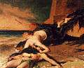
- The Greek myth of Hero and Leander takes place in the ancient city of Sestus.
- Aeneas founded the city of Aenus while trying to find new lands during his mythological conquests.
- After the death of Alexander the Great, in the period called the Diadochi, Alexander's general Lysimachus (360-281 BC) became king of Thrace and established his capital in Lysimachia.
- Çimpe Castle was the first European territory held by the Ottoman Empire.
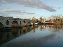
- Edirne was the second capital of the Ottoman Empire after Bursa.
- The Gallipoli Campaign, one of the most important campaigns of the First World War, was fought on the Gallipoli peninsula.
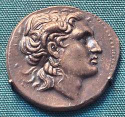 Coin of Lysimachus
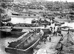 Cape Helles during the Gallipoli Campaign
The mass killings and displacement of Thracian Bulgarians in 1913 and the 1923 population exchange between Greece and Turkey ethnically cleansed the Orthodox populations.
Prior to that the distribution of ethnoreligious groups in the local sanjaks was as follows:
| Ottoman Official Statistics, 1910[5] | |||||||
| Sanjak | Turks | Greeks | Bulgarians | Others | Total | ||
|---|---|---|---|---|---|---|---|
| Edirne | 128,000 | 113,500 | 31,500 | 14,700 | 287,700 | ||
| Kırk Kilise | 53,000 | 77,000 | 28,500 | 1,150 | 159,650 | ||
| Tekirdağ | 63,500 | 56,000 | 3,000 | 21,800 | 144,300 | ||
| Gallipoli | 31,500 | 70,500 | 2,000 | 3,200 | 107,200 | ||
| Çatalca | 18,000 | 48,500 | N/A | 2,340 | 68,840 | ||
| Istanbul | 450,000 | 260,000 | 6,000 | 130,000 | 846,000 | ||
| Total % | 744,000 46.11% | 625,500 38.76% | 71,000 4.40% | 173,190 10.74% | 1,613,690 | ||
| Ecumenical Patriarchate Statistics, 1912 | |||||||
| Total % | 604,500 36.20% | 655,600 39.27% | 71,800 4.30% | 337,600 20.22% | 1,669,500 | ||
The Muslim millet was recorded as Turkish, while the church members of the Ecumenical Patriarchate as Greek.
In the past century modern East Thrace was the main component of the territory of the Adrianople Vilayet, which excluded the Constantinople Vilayet, but included West Thrace and parts of the Rhodopes and Sakar. A publication from December 21, 1912 in the Belgian magazine Ons Volk Ontwaakt (‘Our Nation Awakes’) estimated 1,006,500 inhabitants in the vilayet:[6]
- Muslim Turks - 250,000
- Muslim Bulgarians - 115,000
- Muslim Roma people - 15,000
- Orthodox Armenians - 30,000
- Orthodox Greeks - 220,000
- Orthodox Bulgarians - 370,000
- Orthodox Albanians - 3,500
- Orthodox Turks - 3,000
See also
References
- ↑ Zdanowski, Jerzy (2014). Middle Eastern Societies in the 20th Century. Cambridge Scholars Publishing. p. 11. ISBN 978-1443869591.
- ↑ "Inland fisheries of Europe".
- ↑ "Turkey - Geography".
- ↑ "Turkish Statistical Institute. Registered population as of 2012". Archived from the original on 2012-10-10.
- ↑ Pentzopoulos, Dimitri (2002). The Balkan exchange of minorities and its impact on Greece. C. Hurst & Co. Publishers. pp. 31–32. ISBN 978-1-85065-702-6.
- ↑ Published on December 21, 1912 in the Belgian magazine Ons Volk Ontwaakt (Our Nation Awakes) - view the table of Vilajet Manastir: Skynet GodsdBalkan
| Main peninsulas | |
|---|---|
| Peninsulas in Thrace | |
| Peninsulas in Anatolia | |
| Related geographical features | |