Eastern Harbour Crossing
| |
|---|---|
| Part of Route 2 | |
| Route information | |
| Maintained by Highways Department | |
| Length | 3.3 km (2.1 mi) |
| Existed | 1989[1] – present |
| Major junctions | |
| West end | Quarry Bay |
|
2 in total; | |
| East end | Lam Tin (near Cha Kwo Ling) |
| Location | |
| Major cities | Kwun Tong, Quarry Bay |
| Highway system | |
| Hong Kong Strategic Route and Exit Number System | |

| Eastern Harbour Crossing | |||||||||||
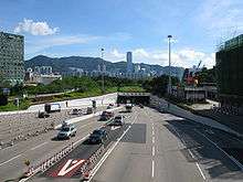 Entrance to Eastern Harbour Crossing at Cha Kwo Ling | |||||||||||
| Traditional Chinese | 東區海底隧道 | ||||||||||
|---|---|---|---|---|---|---|---|---|---|---|---|
| Simplified Chinese | 东区海底隧道 | ||||||||||
| |||||||||||
The Eastern Harbour Crossing, abbreviated as "EHC" (東隧), is a tunnel in Hong Kong. It is a combined road and MTR rail link under Victoria Harbour between Quarry Bay in Hong Kong Island and Cha Kwo Ling in Kowloon East.
History
The Hong Kong Government negotiated with several consortia to adopt the Build-Operate-Transfer (BOT) model in planning new tunnels in different parts of the city.
In 1986, the government gave New Hong Kong Tunnel the right to run the Tunnel on a 30-year franchisee with lease expiring in August 2016. The tunnel features two components, a road part and a rail part:
- The road part of the tunnel is branded as Eastern Harbour Tunnel, although the government refers to the tunnel itself as Eastern Harbour Crossing. The tunnel is governed by the Eastern Harbour Crossing Ordinance. The road part links the Island Eastern Corridor in Hong Kong Island, Lei Yue Mun Road, Tseung Kwan O Tunnel and the Kwun Tong Bypass in Kowloon East.
- The rail part runs between Quarry Bay and Yau Tong stations of the MTR Tseung Kwan O Line.
The powerful Chinese investment group CITIC Pacific is interested in both parts, controlling the road part (71% stake) and has a 50% stake in the rail part. CITIC also controls 50% of the Western Harbour Tunnel Company.
The Tunnel is located right next to a public housing residential complex – Yau Lai Estate.
Tunnel tolls
Tolls are collected manually or electronically in both directions at the toll plaza on the Kwun Tong side.
| Category | Vehicle | Toll ($)[Note 1][2] |
|---|---|---|
| 1 | Motorcycle | 13 |
| 2 | Private car | 25 |
| Taxi | ||
| 3 | Public light bus | 38 |
| Private light bus | ||
| 4 | Light goods vehicle (less than 5.5 tonnes) | |
| 5 | Medium goods vehicle (5.5 to 24 tonnes) | 50 |
| 6 | Heavy goods vehicle (more than 24 tonnes) | 75 |
| 7 | Single-decker bus | 50 |
| 8 | Double-decker bus | 75 |
| Additional axle | 25 |
Notes
- ↑ As of 4 November 2012
Interchanges
| Eastern Harbour Crossing | ||
| Westbound exits | Exit number | Eastbound exits |
| End of Route 2 intersects with Island Eastern Corridor | ||
| End Eastern Harbour Crossing |
Start Eastern Harbour Crossing | |
| Tai Koo Shing,Sai Wan Ho,Shau Kei Wan, Chai Wan,Siu Sai Wan, Stanley, Shek O Island Eastern Corridor |
1A | no exit |
| Quarry Bay,North Point, Causeway Bay, Happy Valley, Aberdeen Island Eastern Corridor |
1B | no exit |
| Eastern Harbour Crossing | ||
| Start Eastern Harbour Crossing |
End Eastern Harbour Crossing continues as Lei Yue Mun Road | |
Traffic
According to the operator, in 2013, a total number of 26.3 million vehicles used the Eastern Harbour Crossing. The average daily throughput was 72.1 thousands.
There are many cross-harbour bus routes that travel through the Eastern Harbour Crossing, operated by Kowloon Motor Bus, New World First Bus and Citybus.
Detailed bus routes
- Kowloon Motor Bus/New World First Bus: 302, 302A, 601, 601P, 641, 680, 680B, 680P, 680X
- Kowloon Motor Bus/Citybus: 307, 307A, 307B, 307P, 606, 606A, 606X, 619, 619P, 619X, 621, 671, 678, 681, 681P, 690, 690P
- Kowloon Motor Bus: 373, 603, 603A, 603P, 603S, 613, 673, 673P
- New World First Bus: 680A, 682, 682A, 682B, 682C, 682P, 694
- Citybus: 608
- Overnights: N619, N680, N691
Controversies
In June 2005, CITIC decided to raise the toll for using Eastern Harbour Crossing from HK$15 to HK$25 for private vehicles and up to 67% for other classes of vehicles, under the fare adjustment mechanism derived from the build-operate-transfer (BOT) model.[3] This increase aroused criticisms that the model was detrimental to the public interest, with the increase shifting more traffic to the already congested Cross-Harbour Tunnel.
See also
| Wikimedia Commons has media related to Eastern Harbour Tunnel. |
References
- ↑ "Transport in Hong Kong – Tunnels and Bridges". Transport Department of the Government of Hong Kong. Retrieved 29 October 2012.
- ↑ "Transport Department Tunnels and Bridges". Transport Department of the Government of Hong Kong. Archived from the original on 9 May 2013. Retrieved 3 November 2012.
- ↑ Ng, Dennis (4 May 2005). "Toll hike ignites call for government to take control". The Standard. Archived from the original on 16 October 2007. Retrieved 27 October 2006.
External links
| Preceded by Southern Terminus |
Hong Kong Route 2 Eastern Harbour Crossing |
Succeeded by Lei Yue Mun Road |
Coordinates: 22°17′58.15″N 114°13′51.97″E / 22.2994861°N 114.2311028°E