Dubach, Louisiana
Home of MF Woods
| Town of Dubach | |
|---|---|
| Town | |
 Dubach: Dogtrot Capital of the World | |
 Location of Dubach in Lincoln Parish, Louisiana. | |
.svg.png) Location of Louisiana in the United States | |
| Coordinates: 32°41′59″N 92°39′26″W / 32.69972°N 92.65722°WCoordinates: 32°41′59″N 92°39′26″W / 32.69972°N 92.65722°W | |
| Country | United States |
| State | Louisiana |
| Parish | Lincoln |
| Area[1] | |
| • Total | 1.88 sq mi (4.87 km2) |
| • Land | 1.82 sq mi (4.71 km2) |
| • Water | 0.06 sq mi (0.16 km2) |
| Elevation | 164 ft (50 m) |
| Population (2010) | |
| • Total | 961 |
| • Estimate (2016)[2] | 966 |
| • Density | 531.65/sq mi (205.27/km2) |
| Time zone | UTC-6 (CST) |
| • Summer (DST) | UTC-5 (CDT) |
| Area code(s) | 318 |
| FIPS code | 22-21800 |
| Website | http://www.dubachla.com |


Dubach is a town in Lincoln Parish, Louisiana, United States. The population was 961 at the 2010 census, an increase from 800 in 2000. Dubach High School, located centrally in the town, is noted for fielding good athletic teams in basketball and often defeats teams from much larger towns and cities. Dubach is also known as the "Dogtrot Capital of the World" because of the presence of numerous nearby dogtrot houses.
Dubach is part of the Ruston Micropolitan Statistical Area.
History
Dubach also had a semiprofessional baseball team, part of the North Louisiana "Big 8", during the 1940s and 1950s. Despite its small size, the team had no trouble recruiting players.
In the fall of 2005, Dubach voters defeated a bond issue that would have funded renovations to Hico Elementary and Dubach High schools. Despite a well-spoken campaign by high school principal Donna Doss, voters killed the issue by a wide margin. Local media speculated that the economic effects of Hurricane Katrina may have swayed voters to err on the side of caution with regards to new taxation.
Geography
Dubach is located at 32°41′59″N 92°39′26″W / 32.69972°N 92.65722°W (32.699768, -92.657286).[3]
According to the United States Census Bureau, the town has a total area of 1.5 square miles (3.9 km2), of which 1.4 square miles (3.6 km2) is land and 0.04 square miles (0.10 km2) (2.72%) is water.
Demographics
| Historical population | |||
|---|---|---|---|
| Census | Pop. | %± | |
| 1910 | 714 | — | |
| 1920 | 726 | 1.7% | |
| 1930 | 608 | −16.3% | |
| 1940 | 749 | 23.2% | |
| 1950 | 703 | −6.1% | |
| 1960 | 1,013 | 44.1% | |
| 1970 | 1,096 | 8.2% | |
| 1980 | 1,161 | 5.9% | |
| 1990 | 843 | −27.4% | |
| 2000 | 800 | −5.1% | |
| 2010 | 961 | 20.1% | |
| Est. 2016 | 966 | [2] | 0.5% |
| U.S. Decennial Census[4] | |||
As of the census[5] of 2000, there were 800 people, 341 households, and 240 families residing in the town. The population density was 561.6 people per square mile (217.5/km²). There were 390 housing units at an average density of 273.8 per square mile (106.0/km²). The racial makeup of the town was 64.62% White, 34.88% African American, 0.38% from other races, and 0.12% from two or more races. Hispanic or Latino of any race were 1.00% of the population.
There were 341 households out of which 29.3% had children under the age of 18 living with them, 45.7% were married couples living together, 22.3% had a female householder with no husband present, and 29.6% were non-families. 27.3% of all households were made up of individuals and 16.1% had someone living alone who was 65 years of age or older. The average household size was 2.35 and the average family size was 2.83.
In the town, the population was spread out with 24.9% under the age of 18, 10.1% from 18 to 24, 25.5% from 25 to 44, 20.4% from 45 to 64, and 19.1% who were 65 years of age or older. The median age was 36 years. For every 100 females, there were 75.1 males. For every 100 females age 18 and over, there were 72.2 males.
The median income for a household in the town was $24,531, and the median income for a family was $30,000. Males had a median income of $32,353 versus $16,538 for females. The per capita income for the town was $15,306. About 17.3% of families and 20.2% of the population were below the poverty line, including 30.5% of those under age 18 and 16.5% of those age 65 or over.
Arts and culture
The Autrey house (and museum) just west of town is the oldest home in the area and is an excellent example of the early and rare form of frontier architecture.
Festivals
Dubach is also home to the Louisiana Chicken Festival, held in late September.
Parks and recreation
Fishing and hunting in the area are among the best in the south. The area woods teem with wildlife, including: squirrel, deer, bobcat, raccoons—even bear and panther. Fishing is available on Bayou D'Arbonne.
Notable person
- C.E. "Cap" Barham, Louisiana Lieutenant Governor who served from 1952–1956, was born in Dubach, but practiced law in Ruston.
References
- ↑ "2016 U.S. Gazetteer Files". United States Census Bureau. Retrieved Jul 2, 2017.
- 1 2 "Population and Housing Unit Estimates". Retrieved June 9, 2017.
- ↑ "US Gazetteer files: 2010, 2000, and 1990". United States Census Bureau. 2011-02-12. Retrieved 2011-04-23.
- ↑ "Census of Population and Housing". Census.gov. Archived from the original on May 12, 2015. Retrieved June 4, 2015.
- ↑ "American FactFinder". United States Census Bureau. Archived from the original on 2013-09-11. Retrieved 2008-01-31.
External links
Municipalities and communities of Lincoln Parish, Louisiana, United States | ||
|---|---|---|
| Cities | 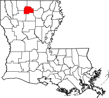 | |
| Towns | ||
| Villages | ||
| Unincorporated communities | ||
| Footnotes | ‡This populated place also has portions in an adjacent parish or parishes | |