Drommedaris (tower)
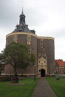
Drommedaris is the historic, 16th century south gate into Enkhuizen in North Holland in the Netherlands. The name comes from the Latin "dromedarius" meaning a camel, referring to the building's shape looking like a camel's hump.
History
Building began in 1540. The site of the building was at the southern entrance to the Oude Haven (old harbour), serving both a defensive and supervisory role to the harbour. The structure is primarily brick, with stone details. The ground floor contains gun-loops through which cannon could be fired. A bell in the tower originally announced the closing of the gate.
The building was originally known as Zuiderpoort (south gate) or Ketenpoort (chain gate). It was later called Wilgenburg, after the Wilgen family who controlled it. Only from the 19th century was it called Drommedaris.
After the Eighty Years War the building was reconstructed broadly to its current form, works being finished in 1657.
The building was restored at least five times during the 20th century. In the Second World War the ornate north door was damaged during a bombing raid on Enkhuizen.
In 1949 the Zuiderzeemuseum found its first home, before finding a permanent location to the north.
Today, it is used as a cultural center and for special events.
A statue of Paulus Potter was placed in front of the tower in 1991.
Bells
The tower contains a carillon of 44 bells of various dates.
The oldest bell dates from 1524 and was cast by Geert van Wou for the Zuiderkerk before being brought to the tower in 1659 as part of a set of ten original bells in the tower.
The current main bell was cast in bronze by in 1775. It bears the Latin inscription "Labor Vincit Omnia: Jan Verbruggen Me Fecit Enchusae 1775" meaning "Work Overcomes Everything: Jan Verbruggen made me in Enkhuizen in 1775". The clock function was restored in the 1970s and in 2014 the upper crown was restored.
Verbruggen had a foundry at Emmaplein, on the edge of Enkhuizen cemetery.
| Dutch Rijksmonument 464878 |
| Wikimedia Commons has media related to Drommedaris. |