Dovhyi Island
| Native name: Довгий Острів | |
|---|---|
 Dovhyi Island | |
| Geography | |
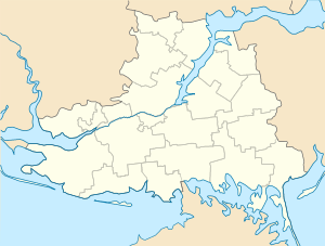
| Coordinates | 46°23′51″N 31°45′6″E / 46.39750°N 31.75167°ECoordinates: 46°23′51″N 31°45′6″E / 46.39750°N 31.75167°E |
| Adjacent bodies of water | Black Sea, Yahorlyk Bay |
| Area | 6 km2 (2.3 sq mi) |
| Length | 6 km (3.7 mi) |
| Width | 1 km (0.6 mi) |
| Administration | |
|
Ukraine | |
| Oblast | Mykolaiv Oblast |
| Raion | Ochakiv Raion |
| Demographics | |
| Population | Uninhabited (2001) |
Dovhyi Island is a small sandy island in Ochakiv Raion, Mykolaiv Oblast in Ukraine.
The island along with Kruhlyi island serves as a separation of Yahorlyk Bay from Black Sea located at the western part of the bay. It is located to the south from Kinburn peninsula. Dovhyi island is 6 km (3.7 mi) in length and about 1 km (0.62 mi) in width.
External links
This article is issued from
Wikipedia.
The text is licensed under Creative Commons - Attribution - Sharealike.
Additional terms may apply for the media files.