Dorsa Sorby
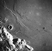
Satellite photo from Apollo 17, Dorsa Sorby is on the bottom-right
Dorsa Sorby is a wrinkle ridge system at 19°00′N 14°00′E / 19.0°N 14.0°E in Mare Serenitatis on the Moon. It is 80 km long and was named after Henry Clifton Sorby in 1976.
The ridges are located southwest of Bobillier crater and east-southeast of Sulpicius Gallus crater. It lies more than halfway between Bobillier and the Sulpicius Gallus B satellite crater towards the southwest.
Further southwest is the Montes Haemus (Lunar Haemus Mountains), to the east is the scarp named Rimae Menelaus and further east is Dorsum Buckland.
External links
This article is issued from
Wikipedia.
The text is licensed under Creative Commons - Attribution - Sharealike.
Additional terms may apply for the media files.