Dofinivka Estuary
| Great Adzhalyk Estuary | |
|---|---|
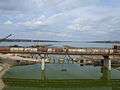
 View of the estuary | |
| Location | Ukraine |
| Coordinates | 46°35′52″N 30°53′24″E / 46.59778°N 30.89000°ECoordinates: 46°35′52″N 30°53′24″E / 46.59778°N 30.89000°E |
| Type | Estuary |
| Primary inflows | Great Adzhalyk |
| Basin countries | Ukraine |
| Max. length | 7.7 km (4.8 mi) |
| Max. width | 1.1 km (0.68 mi) |
| Surface area | 6.0 km2 (2.3 sq mi) |
| Average depth | 0.74 m (2 ft 5 in) |
| Max. depth | 1.2 m (3 ft 11 in) |
| Water volume | 4.5×10⁶ m3 (160×106 cu ft) |
| Salinity | 12.1-13.4 ‰ |
| Settlements | Nova Dofinivka, Vapnyarka |
Dofinivka Estuary, Great Adzhalyk Estuary, or Dofinisvkyi Lyman (Ukrainian: Дофінівський лиман, Великий Аджалицький лиман, Russian: Дофиновский лиман, Большой Аджалыцкий лиман, Turkish: Büyük Adcalik liman), is a brackish water area in South Ukraine, in 12 km to east from Odessa. The water body is an estuary of small steppe river Great Adzhalyk, which inflows to the estuary in northern part. The length of the estuary is about 8 km, width about 1 km. The water body is very shallow, maximal depth is 1.2 m, but average less than 0.5 m.
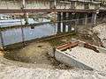
It is separated from the Black Sea by the sandbar. It is artificially connected with the sea by a tube, about 1 m in diameter, since July 2001. The estuary is the shallowest water body in the north-western Black Sea.
References
- Starushenko L.I., Bushuyev S.G. (2001) Prichernomorskiye limany Odeschiny i ih rybohoziaystvennoye znacheniye. Astroprint, Odessa, 151 pp. (in Russian)
- North-western Black Sea: biology and ecology, Eds.: Y.P. Zaitsev, B.G. Aleksandrov, G.G. Minicheva, Naukova Dumka, Kiev, 2006, 701 pp.
Look also