District Management Area
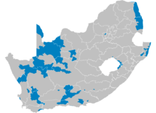
A map of South African districts showing the District Management Areas before 2011
In South Africa, District Management Area (DMA) was the name given to areas within a district municipality that did not fall within any local municipality, and received municipal services directly from the district. Since the 2011 elections all of mainland South Africa has been covered by local (or metropolitan) municipalities, and there are therefore no DMAs.
The DMAs were primarily national parks and nature reserves, or in western parts of South Africa are isolated areas of very low population density.
The table shows the 2007 census population of the DMAs.[1]
| Code | Name | Population 2007 |
|---|---|---|
| ECDMA10 | Cacadu | 5285 |
| ECDMA13 | Chris Hani | 89 |
| FSDMA19 | Thabo Mofutsanyane | 171 |
| GTDMA48 | West Rand | 2918 |
| KZDMA22 | Umgungundlovu | 12 |
| KZDMA23 | Uthukela | 512 |
| KZDMA27 | Umkhanyakude | 10958 |
| KZDMA43 | Sisonke | 814 |
| LIMDMA33 | Mopani | 999 |
| MPDMA32 | Ehlanzeni | 2948 |
| NCDMA06 | Namakwa | 897 |
| NCDMA07 | Pixley ka Seme | 2116 |
| NCDMA08 | Siyanda | 4882 |
| NCDMA09 | Frances Baard | 2588 |
| NCDMA45 | Kgalagadi | 5597 |
| WCDMA01 | West Coast | 7199 |
| WCDMA02 | Cape Winelands | 5260 |
| WCDMA03 | Overberg | 244 |
| WCDMA04 | Eden | 11479 |
| WCDMA05 | Central Karoo | 5609 |
See also
References
- ↑ Statistics South Africa - Community Survey, 2007. Basic Results: Municipalities Archived August 25, 2013, at the Wayback Machine.
This article is issued from
Wikipedia.
The text is licensed under Creative Commons - Attribution - Sharealike.
Additional terms may apply for the media files.