Digital Cadastral DataBase
Digital Cadastral DataBase (DCDB) is a computerised map or 'spatial' location showing property boundaries normally in relation to adjoining and other close properties or parcels of land. Commonly used as a basic layer of data used in map based computer programs that gives an outline of the legal boundary of a property. By using lines to represent an area, features such as rivers and roads can be shown in relation to where a property is.
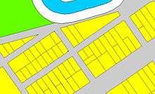
An example of a DCDB file showing properties, road easements and a watercourse
See also
This article is issued from
Wikipedia.
The text is licensed under Creative Commons - Attribution - Sharealike.
Additional terms may apply for the media files.