Devikapuram
| Devikapuram | |
|---|---|
| Town | |
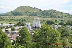 Temple View from hill | |
| Nickname(s): Devikai | |
 Devikapuram Location in Tamil Nadu, India  Devikapuram Devikapuram (India) | |
| Coordinates: 12°28′28″N 79°20′51″E / 12.474433°N 79.347539°ECoordinates: 12°28′28″N 79°20′51″E / 12.474433°N 79.347539°E | |
| Country |
|
| State | Tamil Nadu |
| District | Thiruvanamalai |
| Government | |
| • Body | Town Panchat |
| Population (2001) | |
| • Total | 27,786 |
| Languages | |
| • Official | Tamil |
| Time zone | UTC+5:30 (IST) |
| Vehicle registration | TN 25 |
| Sex ratio | 1:1 ♂/♀ |
| Website | http://www.devikapuram.in/ |

Devikapuram, also called Devigai, is a municipality in Tiruvannamalai district, located in Tamil Nadu, India. The feature of this village are temples, and weaving silk sarees (Arni & Kanchipuram Silk).
Location
Devikapuram is part Thiruvannamali district, Arni taluk, located in Polur-to-Chetput Road (SH-115). It is part of Thondai mandalam. It is a quiet & calm village with out any industry. People lead a pleasant life by doing agriculture and weaving.
Devikapuram is to the West of Vandavasi; to the East of Polur; to the South of Arani and to the North-East of Thiruvannamalai. While going from Vandavasi, after Nedungunam comes Chetput and in the same road towards Polur comes Devikapuram. The temple is located by the right side of the main road.
Transport
- Road
Devikapuram is located on State Highway 115.

This village can be easily reached by bus from:
- Chennai (150 km)
- Thiruvannamalai(50 km)
- Arni (21 km)
- Polur (14 km) and
- Vellore (60 km)
From Vandavasi: Chennai to Vandavasi (via Uthiramerur/Thennangur) – 128 approx km Vandavasi to Chetput – 27 km Chetput to Devikapuram – 12 km
From Arani: Arani – 21 km
From Polur: Polur to Devikapuram – 15 km
Buses are plying to Devikapuram from Chennai ( CMBT )round the clock with Bus No.148( Direct Bus) and Bus No. 131(Via Kanchipuram). Town and mofussil buses from Arni, Chetpet and Polur are available.
- Rail
- Polur is the nearby Railway station. Services have been resumed after the conversion of track. Trains arrives/depart to/from Katpadi, Vellore, Thiruvannamalai, Villupuram, Madurai, Nagarkoil and Mumbai, there daily two trains to tirupati .
- Train details
Air
- Chennai (Domestic & International) (150 km)
- Bangalore (Domestic & International) (350 km)
Temples
- Periyanayagi Amman Temple
- Our lady of good health church
- Ponmalai Nathar Temple, aka Kanagagireeswar (on hill)
- Thiru Kameswar temple
- Balamurugan Temple (on hill)
- Adhiparasakthi temple at the footsteps of hills
- Pillayar temple at pillayar koil st
- Anuman temple
- Few temples for 'village gods' like Muthalamman, Mariamman, Kaali, Throupathi (Panjaali), Pachaiamman
- Aandavar Malai Kolakkaravadi Hill

Economy
- Agriculture (Rice & Sugarcane)
- Milk
- Silk saree production (extensively done by half of the population)
Educational Institutions
- Government boys school (Higher secondary)
- Government girls school (High school)
- Government elementary school
- Cluny Matriculation school (Private)
- RCM School (Elementary level)
- Annamalaiar College of engineering
Banks
- ICICI Bank
- Indian Bank
- Union Bank of India (at near village Mudayur)
- State Bank of India (At nearing village Thachur)
Hospitals
- Primary Health Center
- Few private clinics
- Nirmala clinic cluny