Dakataua
| Dakataua | |
|---|---|
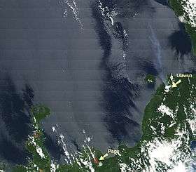 Dakataua lake on the North tip of the Willaumez Peninsula, left of the Pago volcano. On the right there is a steam plume over the sea from the Ulawun volcano. | |
| Highest point | |
| Elevation | 400 m (1,300 ft) |
| Coordinates | 5°3′20″S 150°6′30″E / 5.05556°S 150.10833°ECoordinates: 5°3′20″S 150°6′30″E / 5.05556°S 150.10833°E |
| Geography | |
 Dakataua | |
| Geology | |
| Mountain type | Stratovolcano |
| Volcanic arc/belt | Bismarck volcanic arc |
| Last eruption | 1895 ± 5 years |
The Dakataua Caldera is located at the northern tip of the Willaumez Peninsula, New Britain, Papua New Guinea. The peninsula includes the 350 m high andesitic Mount Makalia stratovolcano. Largest eruption was at 800 AD ±50; VEI 6?; 10 cubic kilometres (2.4 cu mi)? of tephra.[1]
References
This article is issued from
Wikipedia.
The text is licensed under Creative Commons - Attribution - Sharealike.
Additional terms may apply for the media files.