D517 road
| |
|---|---|
_map.png) | |
| Route information | |
| Length | 43.8 km (27.2 mi) |
| Major junctions | |
| From |
|
|
| |
| To |
|
| Location | |
| Counties | Osijek-Baranja |
| Major cities | Beli Manastir, Belišće, Valpovo |
| Highway system | |
| State roads in Croatia | |


Beli Manastir, at the northern terminus of the D517 road
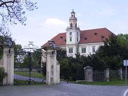
Valpovo, on the D517 road route
D517 is a state road in Slavonia and Baranja regions of Croatia connecting Beli Manastir and Koška, i.e. the D2 and D7 state roads to the D34 state road and the cities of Belišće and Valpovo. The road is 43.8 km (27.2 mi) long.[1]
The road, as well as all other state roads in Croatia, is managed and maintained by Hrvatske ceste, state owned company.[2]
Traffic volume
Traffic is regularly counted and reported by Hrvatske ceste, operator of the road.[3]
| D517 traffic volume | ||||
| Road | Counting site | AADT | ASDT | Notes |
| 2504 Majiške Međe | 1,551 | 1,770 | Adjacent to the Ž4041 junction. | |
| 2403 Belišće - north | 1,503 | 1,855 | Adjacent to the Ž4050 junction. | |
| 2509 Brijest | 5,192 | 5,165 | Adjacent to the Ž4086 junction. | |
Road junctions and populated areas
| D517 junctions/populated areas | |
| Type | Slip roads/Notes |
| Koška The southern terminus of the road. | |
| Harkanovci | |
| Zelčin | |
| Ivanovci | |
| Ž4103 to Marjančaci. | |
| Ž4060 to Ladimirevci and Bizovac (D2). | |
| Valpovo The D34 and D517 roads are concurrent to the north. Ž4051 within the city. Ž4052 within the city. | |
The D34 and D517 roads are concurrent to the south. | |
| Belišće Ž4050 to Valpovo. | |
| Drava River Bridge | |
| Ž4033 to Novo Nevesinje and Torjanci. | |
| Ž4040 to Novi Bezdan. | |
| Baranjsko Petrovo Selo | |
| Ž4041 to Bolman, Uglješ and Švajcarnica (D7). | |
| Petlovac Ž4034 to Luč. | |
| Ž4035 to Šumarina. | |
| Beli Manastir The northern terminus of the road. | |
Sources
- ↑ "Decision on categorization of public roads as state roads, county roads and local roads". Narodne novine (in Croatian). February 17, 2010.
- ↑ "Public Roads Act". Narodne novine (in Croatian). December 14, 2004.
- ↑ "Traffic counting on the roadways of Croatia in 2009 - digest" (PDF). Hrvatske ceste. May 1, 2010. Archived from the original (PDF) on July 21, 2011.
- ↑ "Regulation on motorway markings, chainage, interchange/exit/rest area numbers and names". Narodne novine (in Croatian). May 6, 2003.
This article is issued from
Wikipedia.
The text is licensed under Creative Commons - Attribution - Sharealike.
Additional terms may apply for the media files.