D44 road (Croatia)
| |
|---|---|
| Route information | |
| Length | 50.5 km (31.4 mi) |
| Major junctions | |
| From |
|
|
| |
| To |
|
| Location | |
| Counties | Istria |
| Major cities | Lupoglav, Buzet, Motovun |
| Highway system | |
| State roads in Croatia | |

D44 is a state road connecting A9 motorway Nova Vas interchange to A8 expressway Lupoglav interchange via Buzet.[maps 1] The road is 50.5 km (31.4 mi) long.[1] [2]
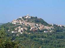
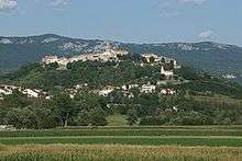
The road also provides connections to numerous towns and cities in central Istria, most notably to Lupoglav, Buzet, Motovun either directly or via numerous roads connecting to D44. Prior to construction of A8 motorway, D44 was the main east-west road communication in the northern Istria, serving touristic resorts in the northern part of Istria.
The road, as well as all other state roads in Croatia, is managed and maintained by Hrvatske ceste, a state-owned company.[3]
Traffic volume
Traffic is regularly counted and reported by Hrvatske ceste, operator of the road.[4] Substantial variations between annual (AADT) and summer (ASDT) traffic volumes are attributed to the fact that the road connects to A8 motorway carrying substantial tourist traffic.
| D44 traffic volume | ||||
| Road | Counting site | AADT | ASDT | Notes |
| 2750 Ponte Porton | 993 | 2,096 | The westernmost traffic counting site on D44. | |
| 2706 Fontana | 2,613 | 3,596 | Adjacent to the Ž5013 junction. | |
| 2806 Lupoglav north | 3,072 | 4,753 | The easternmost traffic counting site on D44. | |
Road junctions and populated areas
| D44 junctions/populated areas | |
| Type | Slip roads/Notes |
The western terminus of the road. | |
| Ž5209 to Buje and Kaštel (D510) (to the north) and Vižinada and Vrh Lima (D75) (to the south). | |
| Ž5007 to Livade, Oprtalj and Buje (to the north) and Motovun and Karojba (to the south). | |
| Ž5010 to Istarske Toplice. | |
| Buzet Ž5011 to Brest and Vodice. Ž5013 to Cerovlje. | |
| Sveti Ivan | |
| Selca | |
| Čiritež | |
| Ročko Polje | |
| Lupoglav Ž5014 to Lanišće and Račja Vas. | |
The eastern terminus of the road. | |
Maps
- ↑ Overview map of the D44 (Map). OpenStreetMap. Retrieved August 25, 2014.
Sources
- ↑ Ministry of Sea, Transport and Infrastructure (Croatia) (May 10, 2013). "Odluka o razvrstavanju javnih cesta" [Decision on categorization of public roads]. Narodne novine (in Croatian) (066/2013).
- ↑ "Interchanges of the Y". BINA-Istra. May 15, 2010.
- ↑ "Public Roads Act". Narodne novine (in Croatian). December 14, 2004.
- ↑ "Traffic counting on the roadways of Croatia in 2013 - digest" (PDF). Hrvatske ceste. May 2014. Retrieved 2014-08-25.