1986–87 South Pacific cyclone season
| 1986–87 South Pacific cyclone season | |
|---|---|
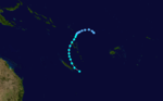
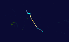
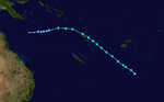
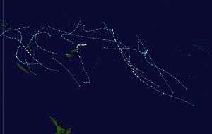 Season summary map | |
| Seasonal boundaries | |
| First system formed | November 20, 1986 |
| Last system dissipated | May 22, 1987 |
| Strongest storm | |
| Name | Uma |
| • Maximum winds |
165 km/h (105 mph) (10-minute sustained) |
| • Lowest pressure | 940 hPa (mbar) |
| Seasonal statistics | |
| Total depressions | 13 |
| Tropical cyclones | 12 |
| Severe tropical cyclones | 6 |
| Total fatalities | 52 |
| Total damage | > $269 million (1986 USD) |
| Related articles | |
The 1986–87 South Pacific cyclone season was an event in the annual cycle of tropical cyclone formation. A total of 13 tropical cyclones developed during the season.
Seasonal summary
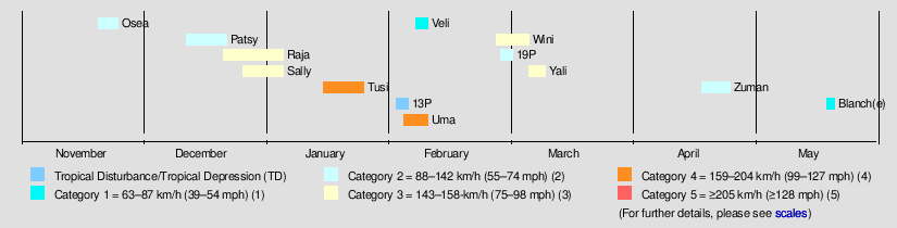
During the season twelve tropical cyclones were recorded within the South Pacific basin, which was considered above average when compared to an 18-year average of 10 systems.[1][2]
Systems
Tropical Cyclone Osea
| Category 2 tropical cyclone (Australian scale) | |
| Tropical storm (SSHWS) | |
  | |
| Duration | November 20 – November 25 |
|---|---|
| Peak intensity | 100 km/h (65 mph) (10-min) 980 hPa (mbar) |
Tropical Cyclone Osea formed about 565 km (350 mi) to the north-northeast of Port Vila on 21 November. It moved on a southerly track parallel to Vanuatu and spent most of its time over the sea. No significant damage was reported.
Tropical Cyclone Patsy
| Category 2 tropical cyclone (Australian scale) | |
| Tropical storm (SSHWS) | |
  | |
| Duration | December 12 – December 22 |
|---|---|
| Peak intensity | 100 km/h (65 mph) (10-min) 975 hPa (mbar) |
On December 12, TCWC Nadi started to monitor a tropical depression that had developed about 1,000 km (620 mi) to the north-northwest of Suva, Fiji.
The system affected Northern Vanuatu but caused little or no damage to the island nation.[3]
Severe Tropical Cyclone Raja
| Category 3 severe tropical cyclone (Australian scale) | |
| Category 2 tropical cyclone (SSHWS) | |
  | |
| Duration | December 21 – January 5 |
|---|---|
| Peak intensity | 150 km/h (90 mph) (10-min) 955 hPa (mbar) |
Cyclone Raja existed from December 21, 1986, to January 5, 1987.
Severe Tropical Cyclone Sally
| Category 3 severe tropical cyclone (Australian scale) | |
| Category 1 tropical cyclone (SSHWS) | |
  | |
| Duration | December 26 – January 6 |
|---|---|
| Peak intensity | 150 km/h (90 mph) (10-min) 955 hPa (mbar) |
Cyclone Sally existed from December 26, 1986, to January 6, 1987.
Severe Tropical Cyclone Tusi
| Category 3 severe tropical cyclone (Australian scale) | |
| Category 3 tropical cyclone (SSHWS) | |
  | |
| Duration | January 13 – January 25 |
|---|---|
| Peak intensity | 150 km/h (90 mph) (10-min) 955 hPa (mbar) |
On January 13, TCWC Nadi started to monitor a tropical depression that had developed, within a trough of low pressure near the island nation of Tuvalu.[4] Over the next few days the system gradually developed further before it was named Tusi during January 16, after it had become equivalent to a modern-day category 1 tropical cyclone on the Australian tropical cyclone intensity scale. After being named the system gradually intensified as it moved southeastwards along the trough, between the islands of Fakaofo and Swains during January 17. Tusi's eye subsequently passed near or over American Samoa's Manu'a Islands early the next day, as the system peaked in intensity with 10-minute sustained wind speeds of 150 km/h (90 mph). The system subsequently posed a threat to the Southern Cook Islands, however this threat gradually diminished as Tusi moved southwards and approached 25S on January 20.
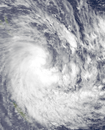
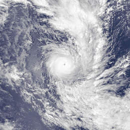
Severe Tropical Cyclone Uma
| Category 4 severe tropical cyclone (Australian scale) | |
| Category 1 tropical cyclone (SSHWS) | |
  | |
| Duration | February 4 – February 10 |
|---|---|
| Peak intensity | 165 km/h (105 mph) (10-min) 940 hPa (mbar) |
Cyclone Uma existed from February 4 to February 10.
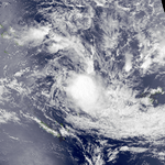
Tropical Cyclone Veli
| Category 1 tropical cyclone (Australian scale) | |
| Tropical depression (SSHWS) | |
  | |
| Duration | February 7 – February 9 |
|---|---|
| Peak intensity | 85 km/h (50 mph) (10-min) 987 hPa (mbar) |
The precursor tropical low to Cyclone Veli formed within the Australian region on February 5, about 725 km (450 mi) to the south-east of Port Moresby in Papua New Guinea.[5] During the next day the low moved eastwards and gradually developed further, before it became equivalent to a category 1 tropical cyclone on the Australian scale, as it reached its 10-minute sustained wind speeds of 85 km/h (55 mph).[5] As the system continued to move eastwards it crossed 160°E and moved into the South Pacific basin during February 7, before the FMS named it Veli later that day on the basis of satellite derived evidence.[5][6] During that day the system continued to move eastwards, before as it passed near to Espitru Santo, Veli started to move steadily towards the south-east.[6] Early the next day the JTWC initiated advisories and started to monitor Veli as Tropical Cyclone 16P, with peak 1-minute sustained windspeeds of 45 km/h (30 mph).[7][8] During that day strong upper level north-westerlies caused vertical windshear to increase over Cyclones Veli and Uma and thus weakened them.[6] During February 9, Cyclone Veli absorbed Uma and formed a complex low, which moved slowly south-eastwards and became extratropical.[6] Damage within Vanautu was either minimal or went unreported, as the island nation was more concerned with the aftermath of Cyclone Uma.[9]
Severe Tropical Cyclone Wini
| Category 3 severe tropical cyclone (Australian scale) | |
| Category 1 tropical cyclone (SSHWS) | |
  | |
| Duration | February 27 – March 7 |
|---|---|
| Peak intensity | 130 km/h (80 mph) (10-min) 965 hPa (mbar) |
Cyclone Wini existed from February 27 to March 7.
Tropical Cyclone Unnamed/19P
| Category 2 tropical cyclone (Australian scale) | |
| Tropical storm (SSHWS) | |
|
| |
| Duration | February 28 – March 3 |
|---|---|
| Peak intensity | 95 km/h (60 mph) (10-min) 985 hPa (mbar) |
Severe Tropical Cyclone Yali
| Category 3 severe tropical cyclone (Australian scale) | |
| Category 1 tropical cyclone (SSHWS) | |
 | |
| Duration | March 5 – March 11 |
|---|---|
| Peak intensity | 120 km/h (75 mph) (10-min) 970 hPa (mbar) |
A shallow tropical depression developed within a monsoon trough of low pressure on March 5, about 485 km (300 mi) to the southeast of Honiara, on the Solomon Island of Guadalcanal.[10][11] Over the next 3 days the system remained as a shallow depression as it moved southwards, before it rapidly developed into a tropical cyclone underneath an upper level ridge of high pressure.[10][12] During March 8, the JTWC classified the system as Tropical Cyclone 22P and initiated advisories on the system, while it was named Yali by the FMS after it had developed into a Category 1 tropical cyclone on the Australian scale.[7][10] During the next day Yali continued to intensify before as the ridge of high pressure moved northwards, before the system peaked with 1 and 10-minute sustained windspeeds of 120 km/h (75 mph).[5][11][12] This made it a category 3 severe tropical cyclone on the Australian tropical cyclone intensity scale and equivalent to a category 1 hurricane on the Saffir-Simpson hurricane scale.[5][11] During the next day Yali rapidly weakened and dissipated over water during March 11.[5][10][11] Despite being within the vicinity of both Vanuatu and New Caledonia, the system did not pass close enough to affect or cause any damage to any inhabited islands.[10][9]
Tropical Cyclone Zuman
| Category 2 tropical cyclone (Australian scale) | |
| Tropical storm (SSHWS) | |
 | |
| Duration | April 19 – April 26 |
|---|---|
| Peak intensity | 100 km/h (65 mph) (10-min) 975 hPa (mbar) |
Cyclone Zuman existed from April 19 to April 26.
Tropical Cyclone Blanch(e)
| Category 1 tropical cyclone (Australian scale) | |
 | |
| Duration | May 20 – May 22 (exited basin) |
|---|---|
| Peak intensity | 75 km/h (45 mph) (10-min) 990 hPa (mbar) |
On May 20, TCWC Nadi started to monitor a tropical depression that had developed about 1,440 km (895 mi) to the northeast of Port Villa, Vanuatu.[5]
Other systems
In addition to 12 named cyclones, two other systems developed during the season. Cyclone 13P existed from February 2 to February 5. Another system, 19P, existed from February 28 to March 3.
Seasonal effects
| Name | Dates active | Peak classification | Sustained wind speeds |
Pressure | Areas affected | Damage (USD) |
Deaths | Refs |
|---|---|---|---|---|---|---|---|---|
| Osea | November 20 – 25 | Category 2 tropical cyclone | 100 km/h (65 mph) | 980 hPa (28.94 inHg) | None | None | None | |
| Patsy | December 12 – 22 | Category 2 tropical cyclone | 100 km/h (65 mph) | 975 hPa (28.80 inHg) | Vanuatu | [9] | ||
| Raja | December 21 – January 5 | Category 3 severe tropical cyclone | 150 km/h (90 mph) | 955 hPa (28.20 inHg) | Tuvalu, Wallis and Futuna, Fiji | $14 million | 2 | [13] |
| Sally | December 26 – January 5 | Category 3 severe tropical cyclone | 150 km/h (90 mph) | 955 hPa (28.20 inHg) | Cook Islands, French Polynesia | $25 million | [14][15] | |
| Tusi | January 13 – 21 | Category 3 severe tropical cyclone | 150 km/h (90 mph) | 955 hPa (28.20 inHg) | Tokelau, Samoan Islands, Cook Islands | $80 million | None | [16] |
| 13P | February 2 – 5 | Tropical Depression | Not Specified | Not Specified | ||||
| Uma | February 4 – 8 | Category 4 severe tropical cyclone | 165 km/h (105 mph) | 940 hPa (27.76 inHg) | Vanuatu | $150 million | 50 | [9][17] |
| Veli | February 7 – 9 | Category 1 tropical cyclone | 85 km/h (50 mph) | 987 hPa (29.15 inHg) | Vanuatu | Minimal | None | [9] |
| 19P | February 28 – March 3 | Category 2 tropical cyclone | 95 km/h (60 mph) | 985 hPa (29.09 inHg) | ||||
| Wini | February 27 – March 7 | Category 3 severe tropical cyclone | 130 km/h (70 mph) | 965 hPa (28.50 inHg) | Western Samoa, American Samoa | Extensive | None | [9] |
| Yali | March 5 – 11 | Category 3 severe tropical cyclone | 120 km/h (75 mph) | 970 hPa (28.65 inHg) | Solomon Islands, Vanuatu, New Caledonia | None | None | [10] |
| Zuman | April 19 – 26 | Category 2 tropical cyclone | 100 km/h (65 mph) | 975 hPa (28.80 inHg) | Western Samoa, American Samoa | |||
| Blanch(e) | May 20–22, 1986 | Category 1 tropical cyclone | 75 km/h (45 mph) | 990 hPa (29.23 inHg) | Solomon Islands | |||
| Season aggregates | ||||||||
| 13 systems | November 20 – May 22 | 165 km/h (105 mph) | 940 hPa (27.76 inHg) | >$269 million | 52 | |||
See also
References
- ↑ Revell, C G (1987). "The 1986/87 Hurricane Season in the South Pacific" (PDF). Weather and Climate. The Meteorological Society of New Zealand. 7 (2): 38–54. Archived from the original (PDF) on December 3, 2013. Retrieved October 10, 2014.
- ↑ Thompson, Craig; Ready, Stephen; Zheng, Xiaogu (1992). Tropical Cyclones in the Southwest Pacific: November 1979 – May 1989 (PDF). New Zealand Meteorological Service, (Meteorological Service of New Zealand Limited, National Institute of Water and Atmospheric Research). p. 32. ISBN 0-477-07346-8. Retrieved 2012-05-10.
- ↑ http://cidbimena.desastres.hn/docum/crid/Agosto2004/pdf/eng/doc5578/doc5578-contenido.pdf
- ↑ Laidlaw, Michael R (February 17, 1987). Tropical Cyclone Report: 87/4: Tropical Cyclone Tusi (PDF) (Report). Fiji Meteorological Service. Archived from the original (PDF) on June 1, 2011. Retrieved September 26, 2014.
- 1 2 3 4 5 6 7 MetService (May 22, 2009). "TCWC Wellington Best Track Data 1967–2006". International Best Track Archive for Climate Stewardship.
- 1 2 3 4 Singh, Sudah; Fiji Meteorological Service (Summer 1987). DeAngellis, Richard M, ed. Tropical Cyclone Veli (Mariners Weather Log). 31. United States National Oceanic and Atmospheric Administration. pp. 24–25. hdl:2027/uiug.30112104093965. ISSN 0025-3367. OCLC 648466886.
- 1 2 Joint Typhoon Warning Center; Naval Western Oceanography Center (1993). Annex A: Warning Verification Statistics: C: Southern Hemisphere (PDF) (1987 Annual Tropical Cyclone Report). United States Navy, United States Airforce. pp. 200–208. Archived (PDF) from the original on June 23, 2013. Retrieved June 23, 2013.
- ↑ Joint Typhoon Warning Center; Naval Pacific Meteorology and Oceanography Center. "Tropical Cyclone 16P (Veli) best track analysis". United States Navy, United States Air Force. Retrieved June 23, 2013.
- 1 2 3 4 5 6 Tropical cyclones in Vanuatu: 1847 to 1994 (PDF) (Report). Vanuatu Meteorological Service. May 19, 1994. Archived from the original on November 18, 2010. Retrieved February 21, 2015.
- 1 2 3 4 5 6 Kishore, Satya; Fiji Meteorological Service (1987). DeAngellis, Richard M, ed. Tropical Cyclone Yali, March 5–12 (Mariners Weather Log: Volume 31: Issue 3: Summer 1987). United States National Oceanic and Atmospheric Administration. p. 25. hdl:2027/uiug.30112104093965. ISSN 0025-3367. OCLC 648466886.
- 1 2 3 4 "Tropical Cyclone 22P (Yali) Best Track Analysis". United States Joint Typhoon Warning Center. Retrieved May 20, 2012.
- 1 2 Darwin Regional Specialized Meteorological Centre (1987). "March 1987" (PDF). Darwin Tropical Diagnostic Statement. Australian Bureau of Meteorology. 7 (2): 2. ISSN 1321-4233. Archived (PDF) from the original on May 20, 2012. Retrieved May 20, 2012.
- ↑ Laisenia, Tui (July 3, 2010). "Disaster Risk Management Risk — Fiji" (PDF). Fiji National Disaster Management Office. Sentinel Asia. Retrieved July 1, 2011.
- ↑ Kishore, Satya (March 26, 1987). Tropical Cyclone Sally (PDF) (Tropical Cyclone Report: 87/5). Fiji Meteorological Service. Archived from the original (PDF) on 2011-06-01. Retrieved June 1, 2011.
- ↑ "Another cyclone hits cook islands". Xinhua General Overseas News Service. January 20, 1987. – via Lexis Nexis (subscription required)
- ↑ Laidlaw, Michael R (February 17, 1987). Tropical Cyclone Tusi (PDF) (Tropical Cyclone Report: 87/4). Fiji Meteorological Service. Archived from the original (PDF) on June 1, 2011. Retrieved June 1, 2011.
- ↑ "A Special Submission to the UN Committee for Development Policy on Vanuatu's LDC Status A" (PDF). The Government of Vanuatu. United Nations. March 4, 2009. pp. 8–9. Archived from the original (PDF) on February 25, 2010. Retrieved August 9, 2010.
External links
- World Meteorological Organization
- Australian Bureau of Meteorology
- Fiji Meteorological Service
- New Zealand MetService
- Joint Typhoon Warning Center