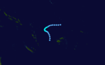
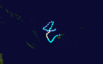
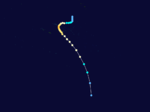
1982–83 South Pacific cyclone season
| 1982–83 South Pacific cyclone season | |
|---|---|
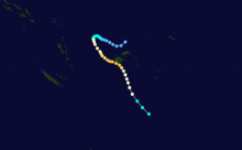
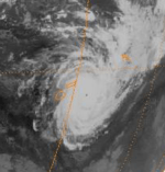
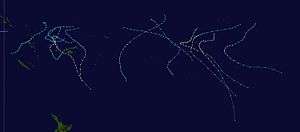 Season summary map | |
| Seasonal boundaries | |
| First system formed | October 31, 1982 |
| Last system dissipated | May 16, 1983 |
| Strongest storm | |
| Name | Oscar |
| • Maximum winds |
205 km/h (125 mph) (10-minute sustained) |
| • Lowest pressure | 920 hPa (mbar) |
| Seasonal statistics | |
| Total depressions | 16 |
| Tropical cyclones | 14 |
| Severe tropical cyclones | 10 (record high) |
| Total fatalities | ≥18 |
| Total damage | > $132 million (1983 USD) |
| Related articles | |
The 1982–83 South Pacific cyclone season was one of the most active and longest South Pacific tropical cyclone seasons on record, with 16 tropical cyclones occurring within the South Pacific basin between 160°E and 120°W. During the season tropical cyclones were monitored by the meteorological services of Australia, Fiji, French Polynesia and New Zealand. The United States Armed Forces through the Joint Typhoon Warning Center (JTWC) and Naval Pacific Meteorology and Oceanography Center (NPMOC), also monitored the basin and issued unofficial warnings for American interests. The first tropical cyclone of the season developed a day before the season officially began on October 31, while the last tropical cyclone of the season dissipated on May 16. Most of the activity during the season occurred within the central and eastern parts of the basin with French Polynesia affected by several systems.
Seasonal summary
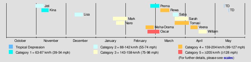
The 1982–83 season was one of the most active and longest South Pacific tropical cyclone seasons on record, with 14 tropical cyclones occurring within the South Pacific basin between 160°E and 120°W. The season was characterised by a very strong El Niño event, which resulted in eleven tropical cyclones occurring to the east of the International Dateline. Five of these tropical cyclones went on to affect the island nation of French Polynesia, which it was thought had not been affected by a tropical cyclone since another very strong El Nino episode in 1905-06.[1]
During the season, ten of the fourteen tropical cyclones observed to the east of 160 E were severe tropical cyclones, with 5 of them occurring in the French Polynesia region which represented one more than was experienced in the same area over the previous 13 seasons.[2]
After the season had officially ended during April 30, meteorologists at the University of Hawaii identified that two tropical depressions developed on May 11 and May 16.[3] The tropical depression that developed during May 11 was thought to be the easternmost forming South Pacific tropical cyclone ever observed in the satellite era, as it developed near 110°W.[3] In April 2015, a cyclone was suspected to have become subtropical near 102.9°W, and was unofficially named "Katie" by researchers. However, since the system is not in the official database, its record is henceforth unofficial.[4]
Systems
Tropical Cyclone Joti
| Category 2 tropical cyclone (Australian scale) | |
| Category 1 tropical cyclone (SSHWS) | |
  | |
| Duration | October 30 – November 7 |
|---|---|
| Peak intensity | 110 km/h (70 mph) (10-min) 975 hPa (mbar) |
The system that was to become Tropical Cyclone Joti was first noted by the Central Pacific Hurricane Center (CPHC) during October 30, while it was located about 1,000 km (620 mi) to the north-east of Port Villa in Vanuatu.[5][6] Over the next day, the disturbance gradually developed further, as its outflow increased and atmospheric convection surrounding the system organised.[5] The disturbance was subsequently named Joti at 00:00UTC (12:00 FST) on November 1, by the FMS, as it had developed into a tropical cyclone.[5] As a result, this made Joti one of the earliest tropical cyclones ever recorded within the basin.[5] After it was named, Joti continued to develop as it completed a cyclonic loop, before it started to move south-westwards towards Vanuatu during November 2.[5][6]
During November 3, the FMS reported that Joti had peaked with 10-minute sustained winds of 110 km/h (70 mph), which made it a Category 2 tropical cyclone on the Australian scale.[5][6] The JTWC subsequently reported that the system had peaked with 1-minute sustained winds of 120 km/h (75 mph), which made it equivalent to a Category 1 hurricane on the SSHWS.[6] During that day the system started to move towards the west-south-west and made landfall on the northern Espiritu Santo.[5][6] After the system had moved into the Coral Sea, it gradually weakened and turned towards the south-southwest, before it degenerated into a depression during November 7.[5][6] Within northern Vanautu, Joti damaged houses, gardens and fruit trees.[7]
Tropical Cyclone Kina
| Category 1 tropical cyclone (Australian scale) | |
| Tropical storm (SSHWS) | |
  | |
| Duration | November 6 – November 13 |
|---|---|
| Peak intensity | 75 km/h (45 mph) (10-min) 990 hPa (mbar) |
The system that was to become Tropical Cyclone Kina was first noted on November 6, while it was located just to the east of Tuvalu.[8][9] Over the next few days the system moved south-westwards and gradually developed further, before the JTWC reported that the system had developed into a tropical cyclone, with peak 1-minute sustained winds of 75 km/h (45 mph) during November 10.[9] During that day the FMS also reported that the system had developed into a Category 1 tropical cyclone on the Australian Scale and named it Kina.[8][9] The FMS subsequently estimated during the next day that the system had reached its peak intensity, with 10-minute sustained winds of 75 km/h (45 mph) during November 11.[8][9] Later that day the system's upper level circulation became sheared off from its lower and moved southwards away from it.[8] The degenerating system subsequently passed to the west of Fiji during November 13, before it was last noted during November 16, as it passed over the island of Efate in Vanuatu but no damage was reported.[9][10] The system caused strong winds and rough seas on Viti Levu and in the Yasawas and Mamanutha group of islands.[8] Tourists on the Blue Lagoon Cruise in the Yasawas were forced to take shelter from Kina, while 18 people on another boat were temporarily listed as missing as they took shelter.[8]
Tropical Cyclone Lisa
| Category 2 tropical cyclone (Australian scale) | |
| Tropical storm (SSHWS) | |
  | |
| Duration | December 10 – December 18 |
|---|---|
| Peak intensity | 110 km/h (70 mph) (10-min) 975 hPa (mbar) |
During December 10, a shallow tropical depression formed to the west of the Northern Cook Island: Penrhyn and started to move south-eastwards towards French Polynesia.[11] Over the next couple of days, the system gradually developed further before the FMS reported that the system had developed into a tropical cyclone and named it Lisa during December 12.[11] During that day, gale-force winds were observed on Bora Bora before the system caused gas it passed to
Severe Tropical Cyclone Mark
| Category 3 severe tropical cyclone (Australian scale) | |
| Category 1 tropical cyclone (SSHWS) | |
  | |
| Duration | January 20 – February 1 |
|---|---|
| Peak intensity | 150 km/h (90 mph) (10-min) 955 hPa (mbar) |
Mark existed from January 20 to February 1.
Severe Tropical Cyclone Nano
| Category 3 severe tropical cyclone (Australian scale) | |
| Category 1 tropical cyclone (SSHWS) | |
  | |
| Duration | January 21 – January 29 |
|---|---|
| Peak intensity | 120 km/h (75 mph) (10-min) 970 hPa (mbar) |
Nano existed from January 21 to January 29.
Severe Tropical Cyclone Nisha-Orama
| Category 4 severe tropical cyclone (Australian scale) | |
| Category 3 tropical cyclone (SSHWS) | |
  | |
| Duration | February 13 – February 28 |
|---|---|
| Peak intensity | 185 km/h (115 mph) (10-min) 925 hPa (mbar) |
During February 13, a depression developed just to the north of the Marquesas Islands and started moving south-westwards.[12] Over the next four days the system maintained its intensity, before it made a sharp eastwards turn and started to develop further.[12] The system subsequently moved in a counter clockwise loop, which allowed it to develop further and it was declared to be a tropical cyclone and named Nisha by the FMS during February 22.[12] However, by the time Fiji had named it Nisha, the Tahiti Meteorological Service had named it Orama, which was retained in order to save any confusion to the local public.[12] Over the next day, the system started to move south-westwards, while it rapidly intensified, with the FMS estimating 10-minute sustained wind-speeds of 185 km/h (115 mph) during February 24.[12] During that day the system sharply turned south-eastwards and started to gradually weaken, before it was last noted during February 28, as it moved out of the FMS's area of responsibility, while equivalent to a modern-day category 1 tropical cyclone.[12] The Tuamotu Archipelago was the worst hit area with around 30 of its Atolls, either seriously damaged or destroyed with a damage total of around US$1.7 million reported in two villages on Rangiroa.[12]
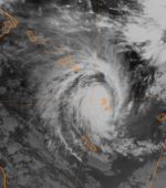
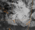
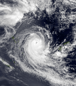
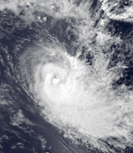
Severe Tropical Cyclone Oscar
| Category 5 severe tropical cyclone (Australian scale) | |
| Category 3 tropical cyclone (SSHWS) | |
  | |
| Duration | February 23 – March 6 |
|---|---|
| Peak intensity | 205 km/h (125 mph) (10-min) 920 hPa (mbar) |
Oscar existed from February 23 to March 6.
Tropical Cyclone Prema
| Category 1 tropical cyclone (Australian scale) | |
| Tropical storm (SSHWS) | |
 | |
| Duration | February 25 – March 6 |
|---|---|
| Peak intensity | 85 km/h (50 mph) (10-min) 987 hPa (mbar) |
During February 25, a depression developed within a trough of low pressure, to the south-west of Manihiki in the Northern Cook Islands.[13][14] The system was named Prema by the FMS during the next day, after it had developed into a category 1 tropical cyclone and peaked, with 10-minute sustained winds of 85 km/h (50 mph).[13][14] After it had been named: Prema moved south-eastwards and started to gradually weaken, before it degenerated into a depression during February 27.[13][14] The remnants of Prema were subsequently monitored over the next few days, as they moved towards and through French Polynesia, before they were last noted during March 6.[14] Prema brought strong to gale-force winds and high seas to the Northern Cook Islands of Penrhyn, Manihiki, Rakahanga and Pukapula.[13] On the atoll of Manihiki, the high seas reached the settlement, with minor damage to coconut trees reported as a result.[13] Gale-force winds caused some serious damage to a wharf, on the atoll of Penhryn.[13] Heavy rain and gale-force winds off 100 km/h (60 mph), caused minor damage to French Polynesia's Leeward and Society Islands.[15][16]
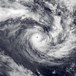
Severe Tropical Cyclone Rewa
| Category 4 severe tropical cyclone (Australian scale) | |
| Category 2 tropical cyclone (SSHWS) | |
  | |
| Duration | March 7 – March 15 |
|---|---|
| Peak intensity | 185 km/h (115 mph) (10-min) 925 hPa (mbar) |
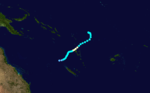
During March 7, a tropical depression developed about 650 km (405 mi) to the northeast of the Society Islands. During that day, the system started to rapidly develop further as it moved and was named Rewa, as it had developed into a Category 1 tropical cyclone.
Rewa exacerbated the destruction caused by Severe Tropical Cyclone Nisha/Orama earlier in the season and destroyed more than 200 houses.
Tropical Cyclone Saba
| Category 2 tropical cyclone (Australian scale) | |
  | |
| Duration | March 20 – March 25 |
|---|---|
| Peak intensity | 95 km/h (60 mph) (10-min) 985 hPa (mbar) |
Saba existed from March 20 to March 25.
Severe Tropical Cyclone Sarah
| Category 4 severe tropical cyclone (Australian scale) | |
| Category 2 tropical cyclone (SSHWS) | |
  | |
| Duration | March 23 – April 4 |
|---|---|
| Peak intensity | 165 km/h (105 mph) (10-min) 940 hPa (mbar) |
During March 23, a shallow tropical depression developed within a trough of low pressure, about 75 km (45 mi) to the northwest of Rotuma.[17] The system subsequently gradually deepened as it moved south-eastwards and passed to the west of the island, before it was named Sarah by the FMS during March 24, after it had developed into a tropical cyclone.[17] The JTWC subsequently initiated advisories on the system and designated it as Tropical Cyclone 18P.
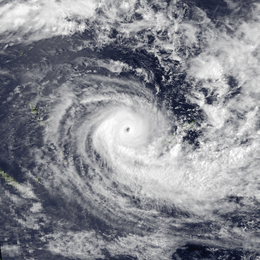
Severe Tropical Cyclone Tomasi
| Category 4 severe tropical cyclone (Australian scale) | |
| Category 3 tropical cyclone (SSHWS) | |
  | |
| Duration | March 27 – April 3 |
|---|---|
| Peak intensity | 185 km/h (115 mph) (10-min) 925 hPa (mbar) |
During March 27, the FMS started to monitor a depression that had developed, within a trough of low pressure about 235 km (145 mi) to the northeast of Penrhyn in the Northern Cook Islands.[18][19] Over the next couple of days, the system moved south-westwards and passed about 140 km (85 mi) to the southeast of Penhryn, as it gradually developed into a tropical cyclone.[18][19] The depression was subsequently named Tomasi by the FMS during March 29, after it had developed into a Category 1 tropical cyclone on the Australian scale.[18] After the system was named, Tomasi went through a period of rapid intensification, with an eye appearing on visible satellite imagery during that day.[18] It was also classified as a Category 3 severe tropical cyclone, before a tropical cyclone alert was issued by the FMS for Niue at around 23:08 UTC (11:08 FST, March 30).[18]
During the next day, Tomasi continued to intensify and move south-westwards, while the alert for Niue was upgraded to a gale warning.[18] Early on March 31, the NPMOC reported that the cyclone had peaked with 1-minute sustained winds of 189 km/h (117 mph), which made it equivalent to a Category 3 hurricane on the SSHWS.[19] Tomasi subsequently turned and started to move southwards, as it passed about 165 km/h (105 mph) to the east of Niue.[19] Later that day, the FMS reported that Tomasi had peaked as a Category 4 severe tropical cyclone, with 10-minute sustained winds of 185 km/h (115 mph).[19] During April 2, the system started to rapidly weaken, with its high clouds being sheared away, before it degenerated into a mid latitude depression.[18] Tomasi remnants moved towards the south-southeast, before it was last noted during April 5.[18][19] Some minor damage to vegetation was reported in Niue, as a result of Tomasi.[18]
Severe Tropical Cyclone Veena
| Category 4 severe tropical cyclone (Australian scale) | |
| Category 3 tropical cyclone (SSHWS) | |
  | |
| Duration | April 8 – April 14 |
|---|---|
| Peak intensity | 185 km/h (115 mph) (10-min) 925 hPa (mbar) |
Veena existed from April 8 to April 14.
Severe Tropical Cyclone William
| Category 3 severe tropical cyclone (Australian scale) | |
| Category 1 tropical cyclone (SSHWS) | |
  | |
| Duration | April 15 – April 23 |
|---|---|
| Peak intensity | 150 km/h (90 mph) (10-min) 955 hPa (mbar) |
William existed from April 15 to April 23.
Seasonal effects
| Name | Dates active | Peak classification | Sustained wind speeds |
Pressure | Areas affected | Damage (USD) |
Deaths | Refs |
|---|---|---|---|---|---|---|---|---|
| Joti | October 31 – November 7 | Category 2 tropical cyclone | 110 km/h (70 mph) | 975 hPa (28.79 inHg) | Vanuatu | Minor | None | [7] |
| Kina | November 6 – 13 | Category 2 tropical cyclone | 110 km/h (70 mph) | 975 hPa (28.79 inHg) | None | None | None | [8] |
| Lisa | December 10 – 18 | Category 2 tropical cyclone | 110 km/h (70 mph) | 975 hPa (28.79 inHg) | Cook Islands French Polynesia | 2 | ||
| Mark | January 20 – February 1 | Category 3 severe tropical cyclone | 150 km/h (90 mph) | 955 hPa (28.20 inHg) | Fiji, Tonga | |||
| Nano | January 21 – 29 | Category 3 severe tropical cyclone | 120 km/h (75 mph) | 970 hPa (28.64 inHg) | French Polynesia | None | ||
| Nisha-Orama | February 13 – 28 | Category 4 severe tropical cyclone | 185 km/h (115 mph) | 925 hPa (27.32 inHg) | French Polynesia | $1.7 million | [12] | |
| Oscar | February 23 – March 6 | Category 5 severe tropical cyclone | 205 km/h (125 mph) | 920 hPa (27.17 inHg) | Fiji | $130 million | 9 | [20] |
| Prema | February 25 – 27 | Category 1 tropical cyclone | 85 km/h (50 mph) | 955 hPa (28.20 inHg) | Northern Cook Islands French Polynesia | Minor | None | [13] |
| Rewa | March 7 – 15 | Category 4 severe tropical cyclone | 185 km/h (115 mph) | 955 hPa (28.20 inHg) | French Polynesia | 5 | ||
| Saba | March 20 – 25 | Category 2 tropical cyclone | 110 km/h (70 mph) | 975 hPa (28.79 inHg) | French Polynesia Pitcairn Island | |||
| Sarah | March 23 – April 4 | Category 4 severe tropical cyclone | 165 km/h (105 mph) | 940 hPa (27.76 inHg) | Fiji | None | [17] | |
| Tomasi | March 27 – April 5 | Category 4 severe tropical cyclone | 185 km/h (115 mph) | 955 hPa (28.20 inHg) | Cook Islands, Niue | Minor | None | [18] |
| Veena | April 8 – 14 | Category 4 severe tropical cyclone | 185 km/h (115 mph) | 955 hPa (28.20 inHg) | French Polynesia | 1 | ||
| William | April 15 – 23 | Category 3 severe tropical cyclone | 185 km/h (115 mph) | 955 hPa (28.20 inHg) | French Polynesia | 1 | ||
| TD | May 11 | Tropical depression | Not specified | Not specified | None | None | None | [3] |
| TD | May 16 | Tropical depression | Not specified | Not specified | None | None | None | [3] |
| Season aggregates | ||||||||
| 15 cyclones | October 31 – May 16 | 215 km/h (130 mph) | 920 hPa (27.17 inHg) | >$132 million | 18 | |||
See also
References
- ↑ http://dailypost.vu/news/developing-el-nino-predicted-stronger-than---dubbed-godzilla/article_fe5cafeb-3ac9-5da5-b17d-9c3f29359515.html
- ↑ Thompson, Craig; Ready, Stephen; Zheng, Xiaogu (1992). Tropical Cyclones in the Southwest Pacific: November 1979 – May 1989 (PDF). New Zealand Meteorological Service, (Meteorological Service of New Zealand Limited, National Institute of Water and Atmospheric Research). ISBN 0-477-07346-8. Archived (PDF) from the original on May 30, 2012. Retrieved May 10, 2012.
- 1 2 3 4 Pacific ENSO Update - Quarter 1, 1998. Pacific ENSO Update (Report). 4. The Pacific ENSO Applications Climate Centre. Archived from the original on April 1, 2014.
- ↑ Blunden, J.; D. S. Arndt (October 2016). "State of the Climate in 2015" (PDF). State of the Climate. American Meteorological Society. 97: 149–150. Bibcode:2016BAMS...97.....B. doi:10.1175/2016BAMSStateoftheClimate.1.
- 1 2 3 4 5 6 7 8 Browne, M.L. (November 24, 1982). Tropical Cyclone Joti Preliminary Report (Report). Fiji Meteorological Service.
- 1 2 3 4 5 6 Knapp, Kenneth R; Kruk, Michael C; Levinson, David H; Diamond, Howard J; Neumann, Charles J (2010). 1983 Joti (1982304S10171). The International Best Track Archive for Climate Stewardship (IBTrACS): Unifying tropical cyclone best track data (Report). Bulletin of the American Meteorological Society. Retrieved July 22, 2017.
- 1 2 Smales, Angus, ed. (December 1, 1982). "Cyclone Jodie visits Vanuatu". Pacific Islands Monthly. Pacific Publications. 53 (12).
- 1 2 3 4 5 6 7 Browne, M.L. (November 24, 1982). Tropical Cyclone Kina Preliminary Report (Report). Fiji Meteorological Service.
- 1 2 3 4 5 Knapp, Kenneth R; Kruk, Michael C; Levinson, David H; Diamond, Howard J; Neumann, Charles J (2010). 1983 Kina (1982311S09181). The International Best Track Archive for Climate Stewardship (IBTrACS): Unifying tropical cyclone best track data (Report). Bulletin of the American Meteorological Society. Retrieved July 22, 2017.
- ↑ Tropical cyclones in Vanuatu: 1847 to 1994 (PDF) (Report). Vanuatu Meteorological Service. May 19, 1994. Archived from the original on November 18, 2010. Retrieved February 21, 2015.
- 1 2 Browne, M.L. (December 29, 1982). Tropical Cyclone Lisa Preliminary Report (Report). Fiji Meteorological Service.
- 1 2 3 4 5 6 7 8 Prasad, Rajendra (April 8, 1983). Tropical Cyclone Nisha (Orama) Preliminary Report (Report). Fiji Meteorological Service.
- 1 2 3 4 5 6 7 Browne, M.L. (March 30, 1983). Tropical Cyclone Prema Preliminary Report (Report). Fiji Meteorological Service.
- 1 2 3 4 Knapp, Kenneth R; Kruk, Michael C; Levinson, David H; Diamond, Howard J; Neumann, Charles J (2010). 1983 Prema (1983056S11193). The International Best Track Archive for Climate Stewardship (IBTrACS): Unifying tropical cyclone best track data (Report). Bulletin of the American Meteorological Society. Retrieved July 22, 2017.
- ↑ "Tahiti's Luck Runs Out". Pacific Magazine. Vol. 8. Pacific Magazine Corporation. pp. 157–158.
- ↑ Hinz, Earl R. "Polynesia". Landfalls of Paradise: Cruising Guide to the Pacific Islands (Fourth ed.). pp. 69–70.
- 1 2 3 Browne, M.L. (April 11, 1983). Tropical Cyclone Sarah Preliminary Report (Report). Fiji Meteorological Service.
- 1 2 3 4 5 6 7 8 9 10 Dey, Sarwen K (May 26, 1983). Tropical Cyclone Tomasi Preliminary Report (Report). Fiji Meteorological Service.
- 1 2 3 4 5 6 Knapp, Kenneth R; Kruk, Michael C; Levinson, David H; Diamond, Howard J; Neumann, Charles J (2010). 1983 Tomasi (1983086S08204. The International Best Track Archive for Climate Stewardship (IBTrACS): Unifying tropical cyclone best track data (Report). Bulletin of the American Meteorological Society. Retrieved July 22, 2017.
- ↑ Costello, D. (1986-12-30). "Fiji prepares for worst as cyclone heads for coast". Courier-Mail.
External links
- World Meteorological Organization
- Australian Bureau of Meteorology
- Fiji Meteorological Service
- New Zealand MetService
- Joint Typhoon Warning Center