1980–81 South-West Indian Ocean cyclone season
| 1980–81 South-West Indian Ocean cyclone season | |
|---|---|
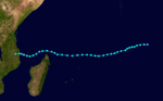
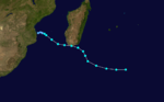
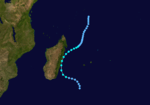
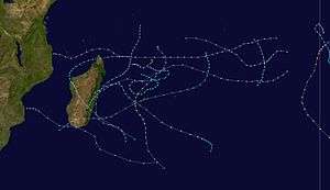 Season summary map | |
| Seasonal boundaries | |
| First system formed | November 8, 1980 |
| Last system dissipated | May 4, 1981 |
| Strongest storm | |
| Name | Florine |
| • Maximum winds |
225 km/h (140 mph) (10-minute sustained) |
| • Lowest pressure | 935 hPa (mbar) |
| Seasonal statistics | |
| Total depressions | 12 |
| Total storms | 10 |
| Tropical cyclones | 3 |
| Intense tropical cyclones | 2 |
| Total fatalities | Unknown |
| Total damage | Unknown |
| Related articles | |
The 1980–81 South-West Indian Ocean cyclone season was an average cyclone season.
Systems
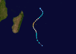
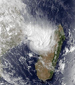
Intense Tropical Cyclone Alice-Adelaide
| Intense tropical cyclone (MFR) | |
| Category 3 tropical cyclone (SSHWS) | |
  | |
| Duration | November 3 – November 14 |
|---|---|
| Peak intensity | 185 km/h (115 mph) (10-min) 940 hPa (mbar) |
Formed on November 3, just south of Selat Mentawai then moved southwestward before reaching a peak intensity of 110 knots (125 mph, 205 km/h) and a minimum pressure of 940.0 hectopascals (27.76 inHg) on November 8. On November 12 the storm began to move northwestward and two days later dissipated over the open Indian Ocean.
Moderate Tropical Storm Bettina
| Moderate tropical storm (MFR) | |
| Tropical storm (SSHWS) | |
  | |
| Duration | November 22 – December 1 |
|---|---|
| Peak intensity | 85 km/h (50 mph) (10-min) |
Bettina formed on November 22, over the central Indian Ocean. It moved south-southwestward and reached a peak intensity of 50 knots (60 mph, 90 km/h) on November 26. It made landfall as a tropical storm over Mozambique and weakened shortly after on December 1.
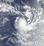
Tropical Cyclone Bert-Christe
| Tropical cyclone (MFR) | |
| Category 1 tropical cyclone (SSHWS) | |
  | |
| Duration | November 24 – December 9 |
|---|---|
| Peak intensity | 140 km/h (85 mph) (10-min) 965 hPa (mbar) |
Formed on November 24 over the open Indian Ocean it moved in a mostly southwest direction, though it did curve a few times. It reached a peak intensity of 80 knots (90 mph, 150 km/h) and a pressure of 965.0 hectopascals (28.50 inHg) on November 29. Christe made landfall on Madagascar on December 9 as a tropical depression.
Tropical Depression Diana
| Tropical depression (MFR) | |
| Tropical storm (SSHWS) | |
  | |
| Duration | December 17 – December 19 |
|---|---|
| Peak intensity | 55 km/h (35 mph) (10-min) |
Diana existed from December 7 to December 19.
Tropical Depression Edwige
| Tropical depression (MFR) | |
| Tropical storm (SSHWS) | |
  | |
| Duration | December 28 – January 1 |
|---|---|
| Peak intensity | 55 km/h (35 mph) (10-min) |
Edwige brushed Madagascar.
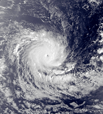
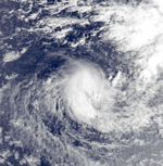
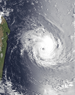
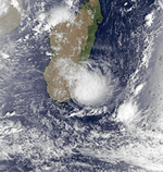
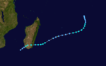
Intense Tropical Cyclone Florine
| Very intense tropical cyclone (MFR) | |
| Category 3 tropical cyclone (SSHWS) | |
  | |
| Duration | January 3 – January 11 |
|---|---|
| Peak intensity | 220 km/h (140 mph) (10-min) 935 hPa (mbar) |
Toward the beginning of January, the ITCZ was active to the northeast of Madagascar, spawning a circulation east of Agalega that became a depression on January 3. On the next day, the system was named Florine. Steered between a ridge to its northwest and northeast, the system moved erratically until January 5, when Florine began a steady movement to the south and later southwest. The change in trajectory was because the ridge to Florine's northeast had weakened. On January 6, the intensifying storm passed just west of St. Brandon, where a station recorded sustained winds of 115 km/h (71 mph) and gusts of 148 km/h (92 mph). A day later, the outer eyewall of Florine moved across Réunion island, while the center of the eye passed 25 km east of Sainte-Rose. Roland Garros Airport recorded a minimum pressure of 935 mbar (27.6 inHg), the lowest on the island. A landfall was spared due to a shift in trajectory to the south-southeast caused by a passing cold front.[1] Also around this time, the cyclone reached its peak intensity according to the JTWC; the agency estimated peak winds of 195 km/h (120 mph), based on a Dvorak rating of 5.5.[2][3] The MFR estimated peak 10 minute winds of 220 km/h (140 mph).[1] Florine weakened as it accelerated ahead of a polar trough, and was no classifiable as a tropical cyclone on January 10. The remnants passed west of Île Amsterdam on the next day and continued southeastward.[1][2]
Florine's close passage to Réunion caused injuries to two people. The high winds, peaking at 234 km/h (145 mph) at Plaine des Cafres, affected the island alongside heavy rainfall. Precipitation totals ranged from 100 mm (4 in) near the coast to 1,161 mm (45.7 in) at Foc-Foc. High tides reached 5.2 m (17 ft) at the coast in La Possession. Cyclone Florine destroyed crops and 95 houses. It caused injuries to two people and left around 500 people homeless. The storm knocked down 2000 phone lines and caused disruptions to the power network. Cilaos and Salazie became isolated during the storm, requiring assistance by helicopter. In nearby Mauritius, winds peaked at 137 km/h (85 mph).[1]
Moderate Tropical Storm Gaelle
| Moderate tropical storm (MFR) | |
| Tropical storm (SSHWS) | |
  | |
| Duration | January 14 – January 18 |
|---|---|
| Peak intensity | 75 km/h (45 mph) (10-min) |
Gaelle existed from January 14 to January 18.
Moderate Tropical Storm Helyette
| Moderate tropical storm (MFR) | |
| Tropical storm (SSHWS) | |
  | |
| Duration | January 28 – February 6 |
|---|---|
| Peak intensity | 75 km/h (45 mph) (10-min) |
Helyette made landfall in Madagascar.
Severe Tropical Storm Iadine
| Severe tropical storm (MFR) | |
| Tropical storm (SSHWS) | |
  | |
| Duration | February 16 – February 25 |
|---|---|
| Peak intensity | 95 km/h (60 mph) (10-min) |
Iadine also made landfall in Madagascar.
Tropical Cyclone Johanne
| Tropical cyclone (MFR) | |
| Category 1 tropical cyclone (SSHWS) | |
 | |
| Duration | March 1 – March 11 |
|---|---|
| Peak intensity | 140 km/h (85 mph) (10-min) |
Johanne existed from March 1 to March 11.
Moderate Tropical Storm Klara
| Moderate tropical storm (MFR) | |
| Tropical storm (SSHWS) | |
 | |
| Duration | March 28 – April 8 |
|---|---|
| Peak intensity | 75 km/h (45 mph) (10-min) |
Klara existed from March 28 to April 8.
Moderate Tropical Storm Lisa
| Moderate tropical storm (MFR) | |
| Tropical storm (SSHWS) | |
 | |
| Duration | April 6 – April 16 |
|---|---|
| Peak intensity | 75 km/h (45 mph) (10-min) |
Lisa existed from April 6 to April 16.
See also
References
- 1 2 3 4 Tropical Cyclone Florine 4–10 January. National Climatic Data Center (Report). Global tropical/extratropical cyclone climatic atlas. 1996. Retrieved 2016-11-20.
- 1 2 Kenneth R. Knapp; Michael C. Kruk; David H. Levinson; Howard J. Diamond; Charles J. Neumann (2010). 1981 Florine (1981003S11059). The International Best Track Archive for Climate Stewardship (IBTrACS): Unifying tropical cyclone best track data (Report). Bulletin of the American Meteorological Society. Retrieved 2016-11-20.
- ↑ John W. Diercks; Robert C. Weir; Mary K. Kopper. Forecast Verification and Reconnaissance Data for Southern Hemisphere Tropical Cyclones (July 1980 through June 1982) (PDF) (Report). Tech Note. 82–1. Joint Typhoon Warning Center. Retrieved November 20, 2016.