Cromwell Township, Huntingdon County, Pennsylvania
| Cromwell Township, Pennsylvania | |
|---|---|
| Township | |
 | |
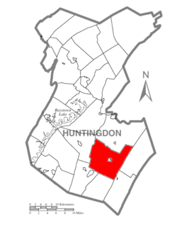 Map of Huntingdon County, Pennsylvania Highlighting Cromwell Township | |
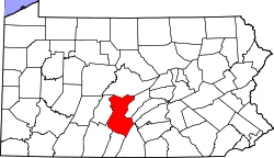 Map of Huntingdon County, Pennsylvania | |
| Country | United States |
| State | Pennsylvania |
| County | Huntingdon |
| Area[1] | |
| • Total | 50.84 sq mi (131.69 km2) |
| • Land | 50.84 sq mi (131.69 km2) |
| • Water | 0.00 sq mi (0.00 km2) |
| Population (2010) | |
| • Total | 1,510 |
| • Estimate (2016)[2] | 1,592 |
| • Density | 31.31/sq mi (12.09/km2) |
| Time zone | UTC-5 (Eastern (EST)) |
| • Summer (DST) | UTC-4 (EDT) |
| FIPS code | 42-061-17280 |
| Historical population | |||
|---|---|---|---|
| Census | Pop. | %± | |
| 2000 | 1,632 | — | |
| 2010 | 1,510 | −7.5% | |
| Est. 2016 | 1,592 | [2] | 5.4% |
| U.S. Decennial Census[3] | |||
Cromwell Township is a township in Huntingdon County, Pennsylvania, United States. The population was 1,510 at the 2010 census.[4]
History
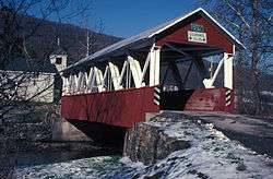
The St. Mary's Covered Bridge was listed on the National Register of Historic Places in 1980.[5]
Geography
According to the United States Census Bureau, the township has a total area of 50.8 square miles (132 km2), all of it land.
Demographics
As of the census[6] of 2000, there were 1,632 people, 580 households, and 436 families residing in the township. The population density was 32.1 people per square mile (12.4/km²). There were 873 housing units at an average density of 17.2/sq mi (6.6/km²). The racial makeup of the township was 99.14% White, 0.37% African American, 0.06% Native American, 0.06% Asian, and 0.37% from two or more races.
There were 580 households, out of which 34.0% had children under the age of 18 living with them, 65.2% were married couples living together, 5.5% had a female householder with no husband present, and 24.8% were non-families. 21.2% of all households were made up of individuals, and 9.1% had someone living alone who was 65 years of age or older. The average household size was 2.57 and the average family size was 2.97.
In the township the population was spread out, with 23.0% under the age of 18, 6.4% from 18 to 24, 27.0% from 25 to 44, 22.5% from 45 to 64, and 21.1% who were 65 years of age or older. The median age was 40 years. For every 100 females there were 92.5 males. For every 100 females age 18 and over, there were 90.3 males.
The median income for a household in the township was $36,629, and the median income for a family was $41,250. Males had a median income of $30,605 versus $18,125 for females. The per capita income for the township was $14,806. About 6.0% of families and 9.4% of the population were below the poverty line, including 11.0% of those under age 18 and 16.1% of those age 65 or over.
References
- ↑ "2016 U.S. Gazetteer Files". United States Census Bureau. Retrieved Aug 14, 2017.
- 1 2 "Population and Housing Unit Estimates". Retrieved June 9, 2017.
- ↑ "Census of Population and Housing". Census.gov. Retrieved June 4, 2016.
- ↑ https://factfinder.census.gov/faces/nav/jsf/pages/community_facts.xhtml#
- ↑ National Park Service (2010-07-09). "National Register Information System". National Register of Historic Places. National Park Service.
- ↑ "American FactFinder". United States Census Bureau. Archived from the original on September 11, 2013. Retrieved 2008-01-31.
Municipalities and communities of Huntingdon County, Pennsylvania, United States | ||
|---|---|---|
| Boroughs | | |
| Townships | ||
| CDPs | ||
| Unincorporated communities | ||
| Ghost town | ||
| Footnotes | ‡This populated place also has portions in an adjacent county or counties | |
Coordinates: 40°14′00″N 77°51′59″W / 40.23333°N 77.86639°W