Catalan Atlas
.jpg)
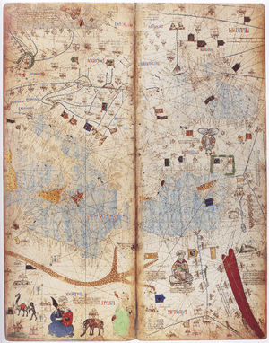
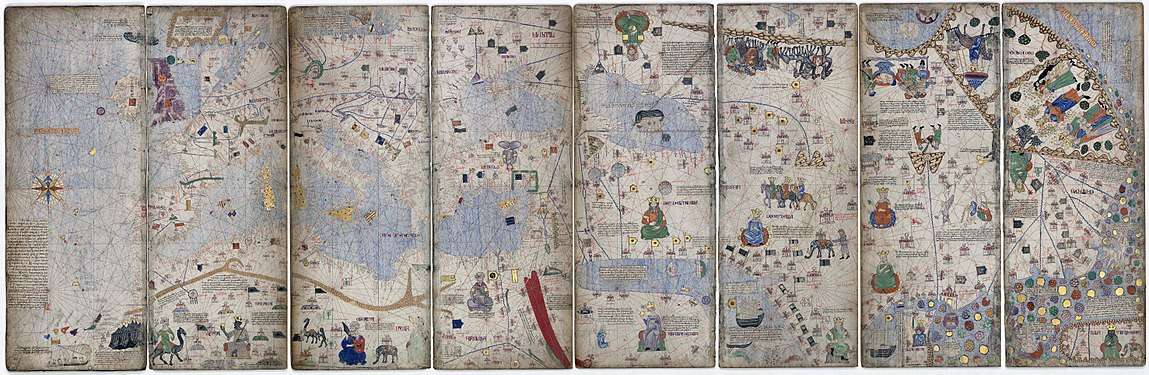
The Catalan Atlas (Catalan: Atles català, Eastern Catalan: [ˈalːəs kətəˈla], archaic spelling: Atlas Catalan) is the most important map of the medieval period in the Catalan language (drawn and written in 1375).[1][2] It was produced by the Majorcan cartographic school and is attributed to Cresques Abraham (also known as "Abraham Cresques"), a Jewish book illuminator who was self-described as a master of the maps of the world as well as compasses.[3] It has been in the royal library of France (now the Bibliothèque nationale de France) since the time of King Charles V. The Catalan Atlas originally consisted of six vellum leaves (each circa 65cm by 50cm) folded vertically, painted in various colors including gold and silver. These were cut in half later, and mounted on wooden panels enclosed in a leather binding.
The first two leaves contain texts in Catalan covering cosmography, astronomy, and astrology. These texts are accompanied by illustrations. The texts and illustration emphasize the Earth's spherical shape and the state of the known world. They also provide information to sailors on tides and how to tell time at night.
The four remaining leaves make up the actual map, with Jerusalem located close to the centre; two depict the Orient and the remaining two Europe and North Africa. The map is around 1.3 square metres in size. The map shows illustrations of many cities, Christian cities with a cross, other cities with a dome, and with each city's political allegiance indicated by a flag. Wavy blue vertical lines are used to symbolize oceans. Place names of important ports are transcribed in red, while others are indicated in black. The illustrations and most of the text are oriented towards the edges of the map, suggesting it was intended to be used by laying it flat and walking around it. [4]
The oriental portion of the Catalan Atlas illustrates numerous religious references as well as a synthesis of medieval mappae mundi and the travel literature of the time, especially Marco Polo's Book of Marvels and Mandeville's Travels and Voyage of Sir John Mandeville. Many Indian and Chinese cities can be identified. The explanatory texts report customs described by Polo and catalogue local economic resources, real or supposed.
The Western portion is similar to contemporary portolan charts, but contains the first compass rose known to have been used on such a chart.
See also
References
- ↑ Cecil Roth (1940). The Jewish Contribution To Civilization. Harper. pp. 69–72. Retrieved 2010-04-28.
- ↑ Clayton J. Drees (2001). The Late Medieval Age of Crisis and Renewal, 1300-1500: A Biographical Dictionary (The Great Cultural Eras of the Western World). Greenwood. pp. 119–120. ISBN 0-313-30588-9.
- ↑ Harwood, Jeremy (2006). To the Ends of the Earth: 100 Maps that Changed the World. F+W Publications Inc.
- ↑ Botton, Jerry (2014). Great Maps. DK Publishing. p. 62. ISBN 9781465435613. Retrieved 26 July 2018.
External links
| Wikimedia Commons has media related to Catalan Atlas. |
- Bibliothèque nationale de France - L'Atlas Catalan (in French)
- The Catalan Atlas (in English) [via archive.org]
- www.cresquesproject.net – translation of the works of Riera i Sans and Gabriel Llompart on the Jewish Majorcan Map-makers of the Late Middle Ages (in English)