Courchevel Altiport
| Courchevel Altiport Altiport de Courchevel | |||||||||||
|---|---|---|---|---|---|---|---|---|---|---|---|
 | |||||||||||
| Summary | |||||||||||
| Airport type | Public | ||||||||||
| Serves | Courchevel | ||||||||||
| Location | Courchevel | ||||||||||
| Elevation AMSL | 2,008 m / 6,588 ft | ||||||||||
| Coordinates | 45°23′51″N 06°38′04″E / 45.39750°N 6.63444°ECoordinates: 45°23′51″N 06°38′04″E / 45.39750°N 6.63444°E | ||||||||||
| Runways | |||||||||||
| |||||||||||
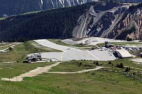
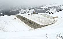
Courchevel Altiport (French: Altiport de Courchevel) (IATA: CVF, ICAO: LFLJ) is an altiport serving Courchevel, a ski resort in the French Alps. The airfield has a very short runway of only 537 metres (1,762 ft) with a gradient of 18.6%.[1] There is no go-around procedure for landings at Courchevel, due to the surrounding mountainous terrain. The airfield primarily sees use by smaller fixed-wing aircraft such as Cessnas as well as helicopters. The runway has no instrument approach procedure or lighting aids, thus making landing in fog and low clouds unsafe and almost impossible.[1]
The airport is considered dangerous, as it features a difficult approach, an upslope runway and ski runs in the adjacent area. The History Channel program Most Extreme Airports ranks it as the seventh most extreme airport in the world.[2]
Commercial Service
In the 1980s, Tyrolean Airways served[3] Courchevel using Dash-7 STOL aircraft capable of carrying 50 passengers. More recently, De Havilland Canada DHC-6 Twin Otters and DHC-7 Dash 7 turboprops have served the airport.
References
- 1 2 3 SIA AIP PDF (in French)
- ↑ Most Extreme Airports, History Channel, October 14, 2010
- ↑ https://www.youtube.com/watch?v=55SswKIn18A
External links
| Wikimedia Commons has media related to Courchevel Altiport. |